Sold2019Cary, John 1812 Large Hand Col Map of England & Wales"A New Map of England and Wales. Adapted to Cary's New Itinerary" Hand Coloured Copper Engraved Map Published 1812, London for "Cary's Traveller's Companion" by John Cary. Paper Size: 19 x 15 inch (48See Sold Price
Sold2022Swire, William 1825 Large Canal & River Map of the UK"Map of the Canals and Navigable Rivers in England, Wales and Scotland" Copper Engraved Map Published 1824-25, Liverpool for "History, Directory, and Gazetteer, of the County Palatine of Lancaster" bySee Sold Price
Sold2022Britain.- Cary (John) Cary's Traveller's Companion or a Delineation of the Turnpike Roads of EnglandBritain.- Cary (John) Cary's Traveller's Companion or a Delineation of the Turnpike Roads of England and Wales, engraved throughout, title, advertisement and contents ff., 43 maps, hand-coloured in ouSee Sold Price
Sold20191821 Carys Road Maps w/ Seven Folding“Cary’s New Itinerary or An Accurate Delineation of the gReat Roads Both Direct and Cross throughout England and Wales …by John Cary; Made by Command of His Majesty’s Postmaster General…”,See Sold Price
Sold20191821 Cary’s Itinerary Volume Roads w/ Maps“Cary’s New Itinerary or An Accurate Delineation of the Great Roads Both Direct and Cross throughout England and Wales; with many of the Principal Roads in Scotland From ab Actual Measurement by JSee Sold Price
Sold20241840 LEWIS MAP of ENGLAND & WALES on LINEN 4 PARTS antiqueLondon: Samuel Lewis, c.1839-1840. Complete in four sheets, dissected and laid on linen, each 35 x 41.5" Bound into original morocco gilt covers, with elaborate gilt tooling. Very good condition of thSee Sold Price
Sold2015Two Hand-Colored Old World MapsTwo Hand-Colored Old World Maps of England/Wales and the Americas, consisting of "Accuratissima Angliae Regni et Walliae Principatus...", engraved by Cornelis Danckerts, ca. 1690-1700, plate 20-1/2" xSee Sold Price
Sold2022Pre-War Johnstons Maps of England and Wales in Original Leather CaseTo be offered on Thursday, 22 September 2022See Sold Price
Sold2021England and Wales.- Ortelius (Abraham) Angliae RegniEngland and Wales.- Ortelius (Abraham) Angliae Regni Florentissimi Nova Descriptio, Auctore Humfredo Lhuyd Denbygiense, map of England and Wales compiled from Mercator's 1564 wall map of the British ISee Sold Price
Sold2022LARGE MAP TRACKING SHIPPING ROUTE BETWEEN ENGLAND AND CHINA 24” x 37.5” sight. FramedLARGE MAP TRACKING SHIPPING ROUTE BETWEEN ENGLAND AND CHINA“A General Chart, on Mercator’s Projection, to shew the Track of the Lion and Hindustan from England to the Gulph of Pekin in ChiSee Sold Price
Sold20241805 John Cary New Map Of Western Territory Of U.S.John Cary was an English cartographerSee Sold Price
Sold2022Britain.- Speed (John) England Wales and Scotland... from a farr Larger Voulume done by John Speed,British Isles.- Speed (John) England Wales and Scotland... from a farr Larger Voulume done by John Speed, engraved title, table of distances, and 63 uncoloured engraved maps by Pieter Van den Keere inSee Sold Price
Sold2024Speed, John England, Wales & Scotland and Ireland Described and AbridgedEngland, Wales & Scotland and Ireland Described and Abridged With ye historic relation of thingsworthy from a farr larger volume. [date unclear.] Small oblong 8vo, engraved title-page, 43 maps only (oSee Sold Price
Sold2024An English Needlepoint MapAn English Needlepoint Map Jane Beilby, 1790 showing the counties of England and Wales. 20 x 20 1/4 inches (sight).See Sold Price
Sold2021Large Matted and Framed Map of Norfolk Virginia:Large Matted and Framed Map of Norfolk Virginia: Stylized Blazon Coat of Arms of Howard Duke of Norfolk (Premier Duke of England) Motto is "Virtuecont Alone is Invincible". Labeled JH DINGEE, Banker,See Sold Price
Sold20231755 Robert De Vaugondy Map of North America Large1755 Robert De Vaugondy Map of America. Mid-Atlantic, New York, New Jersey, Pennsylvania Virginia, Maryland, New England, Carolina and Ohio. Partie De L'Amerique Septentrionale. Map in matte is aboutSee Sold Price
Sold2022Cassini, Giovanni Maria - The Ecclesiastical State divided into its provinces with the adjacentRome, Chalcography Cam.le, 1805. Cm 195 x 187. Map divided into 10 parts with its own title, each consisting of 6 sheets 19 x 31 cm, with numerous ships, a large title cartouche, a cartouche entitledSee Sold Price
Sold2018France.- Ortelius (Abraham) Gallia, detailed map ofFrance.- Ortelius (Abraham) Gallia, detailed map of France, with part of southern England, northern Italy, and includes Belgium and the Netherlands, a large title cartouche with two putto decorating tSee Sold Price
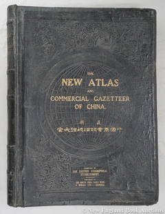
Sold2023Dingle, Edwin John51. Dingle, Edwin John. The New Atlas and Commercial Gazetteer of China. 28 color-printed maps and 18 color-printed statistical tables. Large folio, publisher's black cloth decorated in gilt and blindSee Sold Price
Sold2022MOLL, HERMAN. A New Map of the North Parts of America claimed by France under ye Names of Louisiana,MOLL, HERMAN. A New Map of the North Parts of America claimed by France under ye Names of Louisiana, Mississipi, Canada and New France with ye Adjoyning Territories of England and Spain. Large engraveSee Sold Price
Sold20241816 Cary's Celestial Map Floor Globe19th century Cary's celestial map floor globe, English, 1816. Rests on a tripod stand, inside of which is embedded a compass whose bottom is covered with a paper representing a compass rose. Rising onSee Sold Price
Sold2024Gentleman's Magazine 1778 Canal Map. Belfast to Loughneagh Northern Ireland"A Plan of the River Lagon, and of the intended Navigable Canal from Belfast to Loughneagh?" Copper Engraved Map Published 1778, London for the "Gentleman's Magazine" Folds as issued. Paper Size: 13 xSee Sold Price
Sold2024Gentleman's Magazine 1778 Canal Map. Basingstoke, River Wey, Surrey"A Plan of the Intended Navigable Canal from Basingstoke in the County of Southampton to the River Wey in the county of Surrey" Copper Engraved Map Published 1778, London for the "Gentleman's MagazineSee Sold Price
Sold2022Large Sterling Centerpiece Reily & Storer 1840Charles Reily and George Storer, England. Large sterling trophy, punch bowl or tureen, 1840. The sterling tureen is decorated with scrolling foliate motifs and flowers, and has wonderful horse handlesSee Sold Price
Jun 07Freeman's | HindmanMURCHISON, Roderick Impey, Sir. The Silurian System. 1839. COMPLETE WITH VERY RARE HAND-COLOREDUS$1,500
1 day LeftActivity Auctions1805 1stED Picturesque Scenery of England and Wales Folio 18" Hand Color PlatesUS$4,500
6 days LeftPotter & Potter Auctions[CHROMOLITHOGRAPH]. [NELSON, Lord Horatio (1758-1805), and ...US$300
101 Lots AwayAlbion AuctionsStanford, Edward 1901 Large Map. Russia since the Accession of Peter IUS$5(1 bid)
106 Lots AwayAlbion AuctionsStanford, Edward 1901 Large Map. British Isles - Rainfall and TemperatureUS$5(1 bid)
102 Lots AwayAlbion AuctionsStanford, Edward 1901 Large Map. Balkan Peninsula. Greece Turkey MacedoniaUS$5
5 days LeftHannam's Auctioneers LtdA FINE TWO DAY AUCTION OF ANTIQUES & COLLECTABLES - Formed from a large estate in Caerphilly (Wales)£5


![Speed, John England, Wales & Scotland and Ireland Described and Abridged: England, Wales & Scotland and Ireland Described and Abridged With ye historic relation of thingsworthy from a farr larger volume. [date unclear.] Small oblong 8vo, engraved title-page, 43 maps only (o](https://p1.liveauctioneers.com/94/316498/169880617_1_x.jpg?height=310&quality=70&version=1705579068)


![[CHROMOLITHOGRAPH]. [NELSON, Lord Horatio (1758-1805), and ... (1 of 1)](https://p1.liveauctioneers.com/928/328184/176813370_1_x.jpg?height=282&quality=70&version=1714496988)


