Sold2024Pictorial Map of the United States, 1849PICTORIAL MAP OF THE UNITED STATES 1849. New York: Ensign and Thayer, [ca. 1849.] Sheet 44" x 32.25".*** An attractive hand-colored map providing a view of the United States as it was in the mid-19thSee Sold Price
Sold2021Pictorial Map United States IndiansIndians of the U.S.A. Louise E. Jefferson. Friendship Press, New York: 1944. Novelty map showing native American tribes. Vintage color print. 22 1/2" x 34 1/2", overall 26" x 40".See Sold Price
Sold2022(PICTORIAL MAPS.) R.D. Handy. Paul Bunyan's Pictorial Map of the United States Depicting Some of His(PICTORIAL MAPS.) R.D. Handy. Paul Bunyan's Pictorial Map of the United States Depicting Some of His Deeds and Exploits. Color-printed lithographed pictorial map comically illustrating many geographicSee Sold Price
Sold2017Mitchell: Antique Map of the United States, 1849No. 5 Map of the United States, Mitchell 1849. Very nice impression with great original hand color. Map shows the important territorial acquisitions of the Mexican-American War, pre-Gadsden Purchase pSee Sold Price
Sold20181930s Taylor White Pictorial Map Set of United StatesTitle/Content of Map: 1930s Taylor White Pictorial Map Set of United States for United Airlines -- United Air Lines: A Gay Geography of the Main Line Artery Date: 1930s Cartographer: R Taylor White SiSee Sold Price
Sold20211938 R Taylor White Pictorial Map of the United StatesTitle: 1938 R Taylor White Pictorial Map of the United States -- The United States of America Cartographer: Ruth Taylor White Year / Place: 1938, Boston Map Dimension (in.): 11.6 x 8.5 in. This is RutSee Sold Price
Sold20181938 R Taylor White Pictorial Map of the United StatesTitle/Content of Map: 1938 R Taylor White Pictorial Map of the United States -- The United States of America Date Printed: 1938, Boston Cartographer: Ruth Taylor White Size: 11.6 x 8.5 in. This is RutSee Sold Price
Sold20211938 R Taylor White Pictorial Map of the United StatesTitle: 1938 R Taylor White Pictorial Map of the United States -- The United States of America Cartographer: Ruth Taylor White Year / Place: 1938, Boston Map Dimension (in.): 11.6 x 8.5 in. This is RutSee Sold Price
Sold20151847 Ensigns & Thayer “Pictorial Map of the United1847 Ensigns & Thayer “Pictorial Map of the United States” (chips, minor losses, creases) 29.5” x 41” framedSee Sold Price
Sold20221941 Dudley US Pictorial Map -- America the Wonderland.Title: 1941 Dudley US Pictorial Map -- America the Wonderland. A Pictorial Map of the United States. Designed and Drawn by Ernest Dudley Chase of Winchester, Massachusetts Cartographer: E D Chase YearSee Sold Price
Sold2023CHASE, Ernest Dudley (1878-1966). Two pictorial maps of Ame...CHASE, Ernest Dudley (1878-1966). Two pictorial maps of America. Includes: America the Wonderland / A Pictorial Map of the United States. 1954. Philadelphia: The Inquirer Colorama. Color pictorial mapSee Sold Price
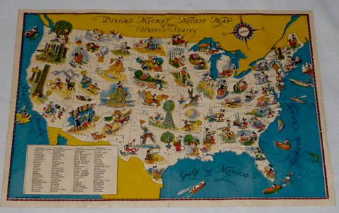
Sold2022Walt Disney Dixon's Mickey Mouse Map of United StatesEarly Disneyana collectible map. Copyright Walt Disney Enterprises 1935. Rare early pictorial map of the United States , richly illustrated with Disney character vignettes in each of the 48 states, MiSee Sold Price
Sold2022CHASE, Ernest Dudley (1878-1966). America the Wonderland. A...CHASE, Ernest Dudley (1878-1966). America the Wonderland. A Pictorial Map of the United States. 1941. Published and copyrighted by Ernest Dudley Chase of Winchester, Mass. Color pictorial map of the USee Sold Price
Sold2015Early MapEarly map of The United States. Marked "New Indexed Pictorial Map of the United States and World....Published By J. R. Spaulding & Co....". Map 43" x 61".See Sold Price
Sold2022KV. Greyhound  / A Good-Natured Map of The United States. 1...KV. Greyhound  / A Good-Natured Map of The United States. 1934. Pictorial map of The United States with the routes of the Greyhound bus lines in black and numerous illustrations of regional attraSee Sold Price
Sold2022COVARRUBIAS, Miguel (1904-1957). The Covarrubias Map of Ame...COVARRUBIAS, Miguel (1904-1957). The Covarrubias Map of America. 1942. Philadelphia: Edward Stern & Co. Pictorial map of the United States, mounted on board, depicting Indigenous peoples, farmers, shiSee Sold Price
Sold2022Edward Gerstell McCandlish (1887-1946) - Bootlegger’s Map of the United States 19261926 version of a famous pictorial map of the United States during Prohibition, humorously satirizing the widespread disobedience of the anti-alcohol laws throughout the nation. McCandlish pokes fun aSee Sold Price
Sold2021Map of the United States and Mexico 1849Heading: Author: Haven, John Title: Map of the United States and Mexico Including Oregon, Texas and the Californias Place Published: New York Publisher:Gates, Steadman & Co. Date Published:See Sold Price
Sold2022Map of United States, JH Colton, ca 1849A framed map of the United States, Map of the United States of America, The British Provinces, Mexico, the West Indies and Central America with part of New Granada and Venezuela by JH Colton, ca 1849,See Sold Price
Sold2019J.H. Colton Map of the United States of America, c 1849J.H. Colton Map of the United States of America, c 1849. 1st edition wall version drawn by George W. Colton and engraved by John M. Atwood with the grapevine border design with small vignettes done anSee Sold Price
Sold2023Antique 1853 Hand Colored United States of America Pictorial Map Thayer Bridgman Fanning PublishersDescribed By:Michelle NODD HFA DBJQ Title:Antique 1853 Hand Colored United States of America Pictorial Map Thayer Bridgman Fanning Publishers Description: Antique 1853 Hand Colored United States of AmSee Sold Price
Sold2023BEMIS, Waldo. Pictorial Fishing or Angling Map of the Unite...BEMIS, Waldo. Pictorial Fishing or Angling Map of the United States. 1941. Map depicts the Continental U.S. and illustrates the distribution of warm and cold-water fish throughout the country, courtesSee Sold Price
Sold2020(PICTORIAL MAP.) McCandlish, Edward. Bootlegger's Map(PICTORIAL MAP.) McCandlish, Edward. Bootlegger's Map of the United States. Large lithographed pictorial map satirizing the proliferation of illegal booze throughout the country during Prohibition. 22See Sold Price
Sold2023MOSS, Ira. Pictorial Wildlife and Game Map of the United St...MOSS, Ira. Pictorial Wildlife and Game Map of the United States. 1956. A.R. Gellman & Co/Shorewood Press. Color pictorial map filled with illustrations of the birds and animals of each state. Shaded iSee Sold Price
May 16Potter & Potter AuctionsHANDY, R.D. (1879 – 1959). Paul Bunyan’s Pictorial Map of t...US$200(1 bid)
May 16Potter & Potter AuctionsCRAVATH, Glen (1897 – 1964). Py Your Leaf Baron Munchausen ...US$80
May 16Potter & Potter AuctionsBOURNE, Emma (1906 – 1986). America – A Nation of One Peopl...US$125(1 bid)
May 16Potter & Potter Auctions[PICTORIAL MAPS – TRAVEL]. Three Pictorial Maps. 1940s/50s....US$150
May 16Potter & Potter AuctionsSTORM, Mark. Official Texas Brags Map of North America. 194...US$200(1 bid)
10 hrs LeftWinter Associates BOOK: Benson John Lossing, "Pictorial History of the Civil War in the United States of America",US$75
3 days LeftHunt and Peck Estate Services, Inc.1849 Alex Mackay 1st US Ed. 2 Vol. "The Western World or Travels in the United States in 1846-1847"US$50
4 days LeftRail & Road AuctionsThree American Aviation Publications - 1953 and 1956 Official Airline Guides and 1948 Air TrafficUS$30
3 days LeftHunt and Peck Estate Services, Inc.1794 Laurie & Whittle after Thomas Jefferys Map Of The United States Of AmericaUS$360(2 bids)
3 days LeftHunt and Peck Estate Services, Inc.1813 "A Concise History of the United States of America from the Discovery of America till 1813"US$100(1 bid)


![Pictorial Map of the United States, 1849: PICTORIAL MAP OF THE UNITED STATES 1849. New York: Ensign and Thayer, [ca. 1849.] Sheet 44" x 32.25".*** An attractive hand-colored map providing a view of the United States as it was in the mid-19th](https://p1.liveauctioneers.com/3532/326332/175680404_1_x.jpg?height=310&quality=70&version=1713150771)


![[PICTORIAL MAPS – TRAVEL]. Three Pictorial Maps. 1940s/50s.... (1 of 4)](https://p1.liveauctioneers.com/928/325952/175495561_1_x.jpg?height=282&quality=70&version=1712935174)


