Sold2020Collection of USGS Topographic MapsCollection of USGS Topographic Maps. Covers portions of Northern Illinois, Most of Wisconsin, some Minnesota. Most maps appear to be from early to mid 1900s. See photos for details. Binder measures 15See Sold Price
Sold20221918 USGS Topographic Map of Minnesota1918 USGS Topographic Map of Minnesota Printed in 1918, based on a survey done in the 1910s of the Brainerd Quadrangle in Minnesota. Map is in good condition with some very small tears around the edgeSee Sold Price
Sold20211922 USGS Topographic Map of Wisconsin1922 USGS Topographic Map of Wisconsin Printed in 1922, based on a survey done in the 1900s of the Sun Prairie Quadrangle in Wisconsin. Map is in good condition with some very small tears around the eSee Sold Price
Sold2023Large Map of Illinois Iowa & MissouriMap of Illinois With map of Iowa and Missouri [separately] on versos Cartographer: George Franklin Cram Dated: Circa 1900 Type: Color LithographSee Sold Price
Sold2022Colton’s Illinois, Iowa & Missouri 1860s school mapExcellent example of an 1860s school atlas map of these Midwestern states. Clean and sound with good ink impression. Shows railroads, roads, towns, cities, rivers, etc. Insets of Vicinity of St. LouisSee Sold Price
Sold2024Francis McNally - Antique Map of Illinois, Missouri & IowaThis is a fine example of McNally's System of Geography by: Francis McNally, published by A.S. Barmes & Co. in 1875. This atlas was made for schools, academies, and seminaries to teach students aboutSee Sold Price
Sold20231852 Owen Geological Map of Wisconsin, Iowa, Minnesota and Parts of Illinois -- Geological Map ofTitle: 1852 Owen Geological Map of Wisconsin, Iowa, Minnesota and Parts of Illinois -- Geological Map of Wisconsin, Iowa and Minnesota: Exhibiting, also the extension of the Iowa Coal-field into MissoSee Sold Price
Sold2022(MIDWEST.) George Woolworth Colton. County & Township Railroad Map of the States of Wisconsin,(MIDWEST.) George Woolworth Colton. County & Township Railroad Map of the States of Wisconsin, Illinois, Missouri & Iowa. Large separately issued lithographed map within a decorative foliate border. 3See Sold Price
Sold2019Nine (9) Augustus Mitchell MapsCollection of late 19th century United States STATE maps including Minnesota, Iowa and Missouri, State of Maine , Illinois-Missouri-Iowa-Nebraska-and Kansas on one, Two Georgia and Alabama, ConnecticuSee Sold Price
Sold20231869 Mitchell Map of US Midwest -- XIV Ohio, Kentucky, Indiana, Illinois, Iowa and Missouri [verso]Title: 1869 Mitchell Map of US Midwest -- XIV Ohio, Kentucky, Indiana, Illinois, Iowa and Missouri [verso] XV Michigan and Wisconsin Cartographer: S Mithchell Year / Place: 1869, Philadelphia Map DimeSee Sold Price
Sold20221851 Geological Map Wisconsin Iowa Minnesota"Geological Map of Wisconsin, Iowa, and Minnesota: Exhibiting, also, the extension of the Iowa Coal-field in Missouri and its relation to the Illinois Coal-field", by David Dale Owen, M.D. Includes inSee Sold Price
Sold2019Colton's Iowa Map [Midwestern States]Colton's Illinois Map. J. H. Colton Cartographer. Published by J. H. Colton, New York. Stamped 'Entered according to Act of Congress in the Year 1855 by J. H. Colton and Co. in in the Clerks Office ofSee Sold Price
Sold2016Geological Chart of Iowa, Wisconsin, & Illinois 1844Map Title: Geological Chart of Part of Iowa, Wisconsin, and Illinois Date: 1844 Publisher: E Weber & Co.: Baltimore Size: 22.75 x 17.75 inches No Reserve: This lot starts at $1 and has no reserve as aSee Sold Price
Sold2020Group of 30 Antique Service Station Road MapsCirca 1930s, Includes Standard Oil, Sinclair, Shell, Sunco, Illinois, Iowa, Oklahoma, and Many MoreSee Sold Price
Sold2023Rare Iowa Sectional Map of the Black Hawk Purchase, Judson, 1838IOWA. A SECTIONAL MAP OF THE BLACK HAWK PURCHASE WITH A PART OF ILLINOIS AND WISCONSIN, by L. Judson, published by Doolittle and Munson, Cincinnati, 1838. Believed to be the first separately publishedSee Sold Price
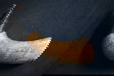
Sold2023Powder Horn with a very detailed map engraved of Northern Illinois and Eastern Iowa. Also hasPowder Horn with a very detailed map engraved of Northern Illinois and Eastern Iowa. Also has Harold Smith engraved in it.See Sold Price
Sold2019Guide to Mid-West with map, 1850Heading: Author: [Smith, John Calvin] Title: The Western Tourist, or Emigrants Guide, through the States of Ohio, Michigan, Indiana, Illinois, Missouri, Iowa and Wisconsin, and the Territories of MinSee Sold Price
Sold2019USA 1911 Lot of 8 State Maps. Encyclopaedia BritannicaIncl Tennesse, Georgia, Iowa, Michigan, Missouri, Illinois, Idaho/Montana and Indiana. Lithograph Maps Published 1911, New York for "The Encyclopaedia Britannica" 11th Edition by Various Contributors.See Sold Price
Sold20181855 Smith Map of the MidWest -- Guide through Ohio,Title/Content of Map: 1855 Smith Map of the MidWest -- Guide through Ohio, Michigan, Indiana, Illinois, Missouri, Wisconsin & Iowa Showing the Township Lines of the United States Surveys Date Printed:See Sold Price
Sold20231853 Colton Map of the US Midwest -- Guide through Ohio, Michigan, Indiana, Illinois, Missouri,Title: 1853 Colton Map of the US Midwest -- Guide through Ohio, Michigan, Indiana, Illinois, Missouri, Wisconsin & Iowa. Showing the Township Lines of the United States Surveys … Cartographer: JSee Sold Price
Sold2019COLTON'S WESTERN TOURIST EMIGRANT'S GUIDE MAP 1853Western Tourist or Emigrant's Guide, circa 1853, location of Cities, Towns, Post Hamlets, Canals and Stage Roads, Ohio, Michigan, Indiana, Illinois, Missouri, Wisconsin, Iowa, plus a wood engraving scSee Sold Price
Sold2020J. Calvin Smith Guide Through Ohio... mapSmith, J. Calvin- ''Guide through Ohio, Michigan, Indiana, Illinois, Missouri, Wisconsin & Iowa'', New York: published by J. H. Colton, 1856, engraved map with hand-coloring folding pocket map. (red cSee Sold Price
Sold2020Group of 30 : Antique (c. 1920s-30s) Service StationCirca 1920s-30s collection of road maps includes Standard Oil, Sinclair, Shell, Phillips 66, Illinois, New York, Iowa, and many moreSee Sold Price
7 days LeftRapid Estate Liquidators and Auction Gallery1910 USGS Topographic Map of Iowa-IllinoisUS$5(1 bid)
Jun 08Connoisseur AuctionsEarly 1900's Railway Service Map, Illinois, Ohio, Indiana, Kentucky, TennesseeUS$20(1 bid)
6 days LeftPiasaDorothea Tanning (Galesburg Illinois, 1910 - New York, 2012) Les Trois Garces, 1953€300,000
Jul 11Dan Morphy AuctionsRARE INDEPENDENT GASOLINE & MOTOR OIL FRAMED GRAPHIC HIGHWAY MAP OF ILLINOIS.US$125
Jun 11Dan Morphy AuctionsLADIES' 14K GOLD PASEDENA CALIFORNIA PRIVATE LABEL POCKET WATCH W/CHAINUS$225(3 bids)
Jun 16Moving Miss Daisy LLC (DBA-Miss Daisy's Consignment & Auction House)Illinois Watch Co. - Antique Pocketwatch - 14K GoldUS$50
Jun 15Crescent City Auction GalleryPair of New Orleans Sanborn Fire Insurance Mock-Up Skeleton Maps of the French Quarter, 1910-1911,US$250
Jun 07Freeman's | HindmanROOSEVELT, Theodore. African Game Trails. 1910. FIRST TRADE EDITION. PRESENTATION COPY INSCRIBED BYUS$400(1 bid)
5 days LeftJasper521852 Norwood Geological Map of Wisconsin and Minnesota -- Geological Map of Parts of Minnesota andUS$55
5 days LeftJasper521852 Owen Map of The Missouri River from Upriver the Platte to Ft. Lawenworth -- Sections of theUS$45
5 days LeftJasper521852 Evans Map of the Badlands -- Map Showing the Position of the Bad Lands or Mauvaises Terres ofUS$60
5 days LeftJasper521852 Owen Map and Views of the Des Moines River from Des Moines to the Mississippi --Series ofUS$70
5 days LeftToomey & Co. AuctioneersJoseph Heinrichs, Fine and Rare humidor with arrowheadsUS$150(2 bids)


![Large Map of Illinois Iowa & Missouri: Map of Illinois With map of Iowa and Missouri [separately] on versos Cartographer: George Franklin Cram Dated: Circa 1900 Type: Color Lithograph](https://p1.liveauctioneers.com/5614/294993/156626705_1_x.jpg?height=310&quality=70&version=1688581746)


![1869 Mitchell Map of US Midwest -- XIV Ohio, Kentucky, Indiana, Illinois, Iowa and Missouri [verso]: Title: 1869 Mitchell Map of US Midwest -- XIV Ohio, Kentucky, Indiana, Illinois, Iowa and Missouri [verso] XV Michigan and Wisconsin Cartographer: S Mithchell Year / Place: 1869, Philadelphia Map Dime](https://p1.liveauctioneers.com/5584/305309/163064973_1_x.jpg?height=310&quality=70&version=1697577828)

![Colton's Iowa Map [Midwestern States]: Colton's Illinois Map. J. H. Colton Cartographer. Published by J. H. Colton, New York. Stamped 'Entered according to Act of Congress in the Year 1855 by J. H. Colton and Co. in in the Clerks Office of](https://p1.liveauctioneers.com/5755/154409/77936937_1_x.jpg?height=310&quality=70&version=1573094011)


![Guide to Mid-West with map, 1850: Heading: Author: [Smith, John Calvin] Title: The Western Tourist, or Emigrants Guide, through the States of Ohio, Michigan, Indiana, Illinois, Missouri, Iowa and Wisconsin, and the Territories of Min](https://p1.liveauctioneers.com/642/140234/71068665_1_x.jpg?height=310&quality=70&version=1555549668)


