Sold2022LAPIE ORIGINAL ANTIQUE MAP ASIA MINOR 1831L' ASIE MINEURE 1831 SIZE: 25.5 X 20 INCHES APPROX. UNFRAMEDSee Sold Price
Sold2017Homann Heirs: Antique Map of Asia, 1746Map: Asia Date Printed: 1746 Cartographer: Homann Heirs Material/Medium: Paper Size: 23 3/4" x 21" Printed in Nuremberg. Hand colored copperplate engraved. Beautiful baroque style cartouche. Please noSee Sold Price
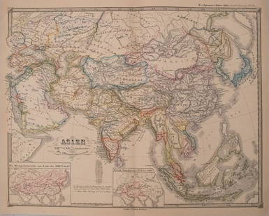
Sold2018Tallis/Rapkin: Antique Map of Asia, 1849TITLE/CONTENT OF MAP: 'Asia' States marked on the map include Siberia, Cochin China, China, Hindoostan, Cabool (Kabul), Turkey, Arabia, Persia, Beloochistan, Birmah, Siam, Malaya, Independent Tartary,See Sold Price
Sold2017Janssonius: Antique Map East Asia. Japan & Korea, 1630Title/Content of Map: East Asia. Japan and Korea (as an island), Amsterdam Date Printed: 1630's Cartographer: Janssonius Joannes Material/Medium: Paper Size: 22" x 19" French text on verso. PublishedSee Sold Price
Sold2017Spruner: Antique Map of Asia, 1855Map: 1855 Spruner Map of Asia -- Asien im Xvten und XVIten Jahrhundrert… Cartographer: K v Spruner Year / Place: 1855 Dimensions: 12.8 x 16.5 in. Condition: Very Good to Excellent. On thick paper, sSee Sold Price
Sold2017Robert de Vaugondy: Antique Map of Asia, 1778Map: 1778 Robert de Vaugondy Map of Asia -- l'Asie par le S. Robert de Vaugoundy Geog ord. du Roi... Cartographer: Robert de Vaugoundy Year / Place: 1778, Paris Dimensions: 9.4 x 10.8 in. Condition: VSee Sold Price
Sold2018Arrowsmith: Antique Map of Asia, 1842Title/Content of Map: Asia Cartographer: ARROWSMITH, J. Size: 19X23.8 Very bright outline colored map. Excellent detail of topography, towns, villages, etc. Also shows roads. Please note that this lotSee Sold Price
Sold2017Mitchell: Rare Antique Map of Asia, 1848Scarce 1848 Mitchell map of Asia. Vivid original hand coloring. Inset of Australia. Shows the entire breadth of Asia. Mitchell maps of the mid-to-late 1840s were some of the better maps produced in AmSee Sold Price
Sold2018Raynal/Bonne: Antique Map of Asia, 1780Asia. M. Bonne. André sculpteur. Overview map with links Poland and the red sea and right Japan and New Guinea. Copper engraving published in G.T.Raynal and R.Bonne; "Atlas De Toutes Les Parties ConnSee Sold Price
Sold2017Perthes: Antique Map of Asia in 15th Century, 1855Map: 1855 Perthes Map of Asia in 15th Century -- Asien gegen die Mitte des Funften Jahrhunderts... Date Printed: 1855, Gotha Cartographer: J Perthes Size: 12.9 x 16.5 in. Condition: Very good-excellenSee Sold Price
Sold2017Perthes: Antique Map of Asia in 13-14th Centuries, 1855Map: 1855 Perthes Map of Asia in the 13th and 14th Centuries -- Asien im XIII-ten & XIV-ten Jahrhundert… Date/Place: 1855, Gotha Cartographer: J Perthes Size: 12.7 x 16 in. Condition: Very good-exceSee Sold Price
Sold2017Natolia quae olim Asia Minor, 16401640 Natolia quae olim Asia Minor. By: Willem Janszoon BlaeuDate: 1640 (circa) Amsterdam. Dimensions: 15 x 19.75 inches (38.1 x 50.2 cm) This is an authentic antique map of Asia Minor that includes CySee Sold Price
Sold202217C. Jodocus Hondius Map of Asia Colored EngravingAntique 17th century map of Asia by Jodocus Hondius (Belgian Dutch, 1563-1612). Colored engraving originally published in 1631. Displayed in a wooden frame. Work Size: 15 x 19.5 in.SHIPPINGHill AuctioSee Sold Price
Sold2017Antique Map of India into Southeast Asia, 1541Map: India into Southeast Asia Date Printed: 1541 Cartographer: Waldseemuller & Friers Material/Medium: Paper Size: 21" X 14 1/4" Condition: Excellent Second oldest Map of India into Malay peninsula.See Sold Price
Sold2017Antique framed map of Indian Ocean, Asia, AustraliaTitle/Content of Map: Antique framed map of Indian Ocean, Asia, Australia Date Printed: 1713 Cartographer: Aa, Pieter van der Size (in): 11 x 8 Very attractive framed copper-engraved antique map by PiSee Sold Price
Sold2023Corea and Japan by John Thomson. East Asia. Korea 1817 old antique map chartTitle: "Corea and Japan" by John Thomson. East Asia. Korea 1817 old antique map chart Description: Corea and Japan' by Drawn & engraved by John & George Menzies for John Thomson's "New General Atlas"See Sold Price
Sold2022Corea and Japan by John Thomson. East Asia. Korea 1817 old antique map chartTITLE/CONTENT OF MAP: 'Corea and Japan' DATE PRINTED: Published in 1817. Engraved on 16th August 1815; this date is marked on the map IMAGE SIZE: Approx 52.5 x 67.0cm, 20.75 x 26.5 inches (Large); PleSee Sold Price
Sold2022Corea and Japan by John Thomson. East Asia. Korea 1830 old antique map chartTITLE/CONTENT OF MAP: 'Corea and Japan' DATE PRINTED: 1830 IMAGE SIZE: Approx 52.0 x 66.5cm, 20.5 x 26.25 inches (Large); Please note that this is a folding map. TYPE: Antique early 19th century atlasSee Sold Price
Sold2024Original Antique Map of China, Macau and Canton - Asia - Jacques Nicolas BellinIts finely engraved, hand-coloring engraved map from the Dutch edition of acques Nicolas Bellin Histoire General des Voyages. Published in Amsterdam, 1770 year. This fine copperplate map from that ediSee Sold Price
Sold2023TWO ANTIQUE MAPS OF CHINA.Two antique maps of China, including Chinae by Abraham Ortelius, 1595, image 14.25” x 18.25”, with map of Eastern Asia, Le table de la region orientale, image 10” x 13.5”.See Sold Price
Sold20244 Antique Maps of Various LocationsFrench Map of Canada By Guillaume Del'Isle, Map Of Asia By Guiljelmo Blaeuw, Double Hemisphere map By Nicolao Visscher, Map Of The Holy Land Jerusalem, all maps are roughly 18" x 14"See Sold Price
Sold2018Tallis/Rapkin: Antique Map of Eastern Hemisphere, 1849TITLE/CONTENT OF MAP: 'Eastern Hemisphere' The steamship mail route from Britain to Asia is indicated in blue DATE PRINTED: 1849 IMAGE SIZE: Approx 26.5 x 34.5cm, 10.5 x 13.5 inches (Large); Please noSee Sold Price
Sold202418th CENTURY MAP OF TURKEY in ASIA ANTIQUE BLACK & MEDITERREANEAN SEASize 8 by 10 1/4" With folds Reserve: $49.00 Shipping: Domestic: Flat-rate of $25.00 to anywhere within the contiguous U.S. International: Foreign shipping rates are determined by destination. InSee Sold Price
Sold2024Central Asia. Trans-Caspian Aral Sea Khiva Bokhara Sirdaria STANFORD 1896 mapCAPTION PRINTED BELOW PICTURE: 'Central Asia' DATE PRINTED: 1896 IMAGE SIZE: Approx 35.5 x 50.5cm, 14 x 20 inches (Large) TYPE: Large (folio) antique atlas map CONDITION: Good; suitable for framing. TSee Sold Price
5 days LeftJasper521755 MAP of RUSSIAN EMPRIRE & INNER ASIA CHINESE TARTARY antique 20 x 27 in.US$100(1 bid)
1 day LeftTrillium Antique Prints & Rare BooksPrevost - Chart of the Islands of Java, Sumatra, Borneo, &c.US$50
1 day LeftTrillium Antique Prints & Rare BooksPrevost - Pair of Engravings of Santo Domingo or HispaniolaUS$50
1 day LeftTrillium Antique Prints & Rare BooksPrevost - 3 Natural History Engravings of Avocado, Passion Flower, Aloe, Flying Squirrel, & LizardUS$50
4 days LeftMark Louis Weseloh Estate LiquidationsSix - 17th c. Maps of Europe, Asia, England, Germany x2, Crete, Greece.8 1/4" x 6 5/8".US$300