Sold2024MAP, Africa, SansonWestern Africa, Cape Verde Islands. Nicolas Sanson, D'Eilanden van Capo Verde, de Kust en't Landt der Negeren..., from Algemeene Weereld-Beschryving…, 1705 (published). Hand Color. This is an attracSee Sold Price
Sold2023MAP, Africa, Robert de VaugondyAfrica. Gilles Robert de Vaugondy, L'Afrique Divisee en ses Principaux Empires et Royaumes par les Srs. Sanson..., 1749 (dated). Hand Color. Gilles Robert de Vaugondy succeeded his uncle, Pierre MoulaSee Sold Price
Sold2018Sanson: North Africa / Patriarchate of Alexandria, 1730Partriarchatus Alexandrini Geographica descriptio The later Covens & Mortier edition of Sanson's map of the Patriarchate of Alexandria encompassing Libya and Egypt, with great detail and many place naSee Sold Price
Sold2017Three maps of Africa and Middle Eastcomprising: 1) Nicolas Sanson, "Haute Ethiopie …" Paris, 1655, engraving, about 16 X 20 in., p.m.; 2) after Sanson, "Description de l'Empire du Sophi des Perses," Paris, c,1730, engraving with old oSee Sold Price
Sold2023L'Africa. DE ROSSI / SANSON 1677 old antique vintage map plan chartTITLE/CONTENT OF MAP: L'Africa [Africa] DATE PRINTED: 1677 IMAGE SIZE: Approx 42.5 x 57.0cm, 16.75 x 22.25 inches (Large) TYPE: Antique 17th century folio atlas map CONDITION: Good; suitable for framiSee Sold Price
Sold2015Berry (William) - Africa Divided according to thelarge map of the continent after Sanson, showing the various nations, empires and kingdoms, title panel above and decorative title cartouche upper right, a detailed manuscript note referring to an accSee Sold Price
Sold2022MAP, Africa, OrteliusOrtelius' Cornerstone Map of Africa. Africa. Abraham Ortelius, Africae Tabula Nova, from Theatrum Orbis Terrarum, 1570 (dated). Black & White. This striking map is one of the cornerstone maps of AfricSee Sold Price
Sold2021Hand colored map, Africa. 23” x 20.5”Hand colored map, Africa. 23” x 20.5”See Sold Price
Sold20181683 Sanson Map of the Great Lakes and the Upper EastTitle/Content of Map: 1683 Sanson Map of the Great Lakes and the Upper East Coast -- Le Canada, ou Nouvelle France, &c. Tiree de diverses Relations des Francois, Anglois, Hollandois, &c. Date: 1683, PSee Sold Price
Sold2022MAP, Africa, MercatorFull Contemporary Color. Africa. Gerard Mercator, Africa ex Magna Orbis Terre Descriptione Gerardi Mercatoris Desumpta, Studio & Industria, from Atlas sive Cosmographicae..., 1609 (circa). Hand Color.See Sold Price
Sold20211683 Sanson Map Great Lakes to Newfoundland -- LeTitle: 1683 Sanson Map Great Lakes to Newfoundland -- Le Canada, ou Nouvelle France, &c. Tiree de diverses Relations des Francois, Anglois, Hollandois, &c. Cartographer: N Sanson Year / Place: 1683 c.See Sold Price
Sold20181683 Sanson Map of the Great Lakes and the Upper EastTitle/Content of Map: 1683 Sanson Map of the Great Lakes and the Upper East Coast -- Le Canada, ou Nouvelle France, &c. Tiree de diverses Relations des Francois, Anglois, Hollandois, &c. Date Printed:See Sold Price
Sold2022MAP, Africa, OrteliusCentral Africa. Abraham Ortelius, Presbiteri Iohannis, sive, Abissinorum Imperii Descriptio, from Theatrum Orbis Terrarum, 1579 (published). Hand Color. This great map depicts the central African kingSee Sold Price
Sold20231652 Sanson Map of the World -- L'Hydrographie ou Descriprion de L'Eau c'est a dire des Mers,Title: 1652 Sanson Map of the World -- L'Hydrographie ou Descriprion de L'Eau c'est a dire des Mers, Golfes, Lacs, Destroits, et Rivieres principales, qui font dans la Surface du Globe Terrestre . . .See Sold Price
Sold2022Alexis Hubert Jaillot and Nicolas Sanson - Map of the Grand Duchy of Moscow, Etching, 1708.Alexis Hubert Jaillot (French, 1632-1712) and Nicolas Sanson (French, 1600-1667) - Map of the White Russia or the Grand Duchy of Moscow, Etching, 1708. Title: Les Estats du Czaar de Russie Blanche ouSee Sold Price
Sold2020Nicolas Sanson Map of AsiaNicolas Sanson (1600-1667) "L'Asie divisee en ses Principales Regions, et ou se peuvent voir l'estendue, Des Empires, Monarchies, Royaumes, et Estats," Paris: Jaillot, ca. 1719. Hand colored map of AsSee Sold Price
Sold2024Sanson - Map of Canada or New France with the Great LakesThis strong map engraving is from the Dutch edition of Nicolas d'Abbeville Sanson's Cartes Generales de Toutes les Parties du Monde. The work was published in Utrecht in 1683 for the author. The atlasSee Sold Price
Sold2024Nicolas Sanson - Map of Asia / Asia divided into its Principal RegionsCopper engraving, 1600s/1700s, "Asia divided into its Principal Regions." By Mr. Sanson, Geographer Ordinary to the King. Size: 58 cm x 88 cm.See Sold Price
Sold2018RARE 17TH C. SANSON MAP OF LUXEMBOURGAlexis-Hubert Jaillot (c. 1632-1712); Nicolas Sanson (1600-1667) "Le Duche de Luxembourg Divise en Quarter Walon et Allemand....", hand colored engraving, published 1700 from earlier plates, Paris, frSee Sold Price
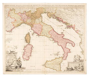
Sold2019Sanson map of Italy 1701Heading: Author: Sanson, Nicolas Title: L'Italie Divisee Suivant l'Estendue de Toutes ses Sourverainetes... Place Published: Amsterdam Publisher:Pieter Schenk Date Published: 1701 DescSee Sold Price
Sold20211652 Sanson Map of the Arabian Peninsula and the RedTitle: 1652 Sanson Map of the Arabian Peninsula and the Red Sea -- L'Arabie Petree, Deserte, et Heureuse Cartographer: N Sanson Year / Place: 1652, Paris Map Dimension (in.): 7.5 X 9.5 in. This is a rSee Sold Price
Sold2023Sanson map of ancient Asia 1650Heading: Author: Sanson, Nicolas Title: Asia Vetus Place Published: Paris Publisher: Date Published: [1650] Description: Copper-engraved map, hand-colored in outline; colored decorSee Sold Price
Sold2022MAP, Africa, MercatorAfrica. Mercator/Jansson, Africae Descriptio, from Atlas Minor, 1630 (published). Hand Color. Fine small map of Africa, which is based largely on the work of Hernicus Hondius and incorporates informatSee Sold Price
Sold20191700 c. Sanson Map of the Arabian Peninsula and the RedTitle/Content of Map: 1700 c. Sanson Map of the Arabian Peninsula and the Red Sea -- Arabia Petrea, Deserta et Felix Per N. Sanson Date: c. 1700 Cartographer: Based on N. Sanson Size: 7.5 X 9.5 in. ThSee Sold Price
Jun 15Trillium Antique Prints & Rare BooksSanson - 5 Maps of Africa (Egypt, Barca, Tunis & Tripoli, Morocco, & Barbary & Alger)US$75
7 days LeftSwann Auction Galleries(AFRICA.) Nicolas Sanson. Group of 10 small-scale engraved regional maps of the continent.US$450
2 days LeftTrillium Antique Prints & Rare BooksSanson - Map of North America with California as an IslandUS$130(4 bids)
2 days LeftTrillium Antique Prints & Rare BooksSanson - Map of California as an Island, Mexico (Audience de Guadalajara)US$160(4 bids)
2 days LeftTrillium Antique Prints & Rare BooksSanson - Map of Moluccas, Celebes, & Gilolo (Halmahera)US$75
5 days LeftJasper521719 Senex Map of France -- A New Map of France, Showing the Roads & Post Stages Throout ThatUS$70
15 hrs LeftHolabird Western Americana CollectionsMap of Africa by Edward Weller c. 1800's [180171]US$60
Jun 15Trillium Antique Prints & Rare BooksSanson - 3 Maps of South America (Chili, Peru, Paraguay)US$75
Jun 15Trillium Antique Prints & Rare BooksSanson - 4 Maps of Europe (Germany, Spain & Portugal, Hungary, & Poland)US$75
6 days LeftJasper52Carte Generale des Royaume d'Angleterre, Escosse et Irelande. SANSON 1651 mapUS$400


![L'Africa. DE ROSSI / SANSON 1677 old antique vintage map plan chart: TITLE/CONTENT OF MAP: L'Africa [Africa] DATE PRINTED: 1677 IMAGE SIZE: Approx 42.5 x 57.0cm, 16.75 x 22.25 inches (Large) TYPE: Antique 17th century folio atlas map CONDITION: Good; suitable for frami](https://p1.liveauctioneers.com/5584/308981/165185503_1_x.jpg?height=310&quality=70&version=1699996168)


![Sanson map of ancient Asia 1650: Heading: Author: Sanson, Nicolas Title: Asia Vetus Place Published: Paris Publisher: Date Published: [1650] Description: Copper-engraved map, hand-colored in outline; colored decor](https://p1.liveauctioneers.com/642/310901/166355383_1_x.jpg?height=310&quality=70&version=1701367957)


![Map of Africa by Edward Weller c. 1800's [180171] (1 of 2)](https://p1.liveauctioneers.com/2699/331495/178785776_1_x.jpg?height=282&quality=70&version=1717094933)


![[MAP]. ORTELIUS, Abraham. Africae Tabula Nova. 1592. (1 of 2)](https://p1.liveauctioneers.com/197/329395/177650533_1_x.jpg?height=282&quality=70&version=1715364962)