Sold2021Antique New York State Map 1903 Color Roll Up RR Map1903 Scarborough's New Railroad, Post Office, Township and County Map of New York. Color map, compiled from the latest government and state surveys and original sources of the era. Insets: Map of NewSee Sold Price
Sold2024Controller Bay Railroad Survey Map Trio [177997]Linen backed projected location of the Kush Ta Ka Railway 28x76". 1903 blue print style 30x30", tears. 1904 Controller Bay, 30x30", small tears. Controller Bay AlaskaSee Sold Price
Sold20201933 VT Rutland Sheet Geological Survey MapDescription: Vintage 1933 VT Rutland Sheet Geological Survey Map, reprinted from a 1893 edition. Henry Gannett, chief topographer, H.M. Wilson, geographer in charge, triangulation by U.S. Coast and GeSee Sold Price
Sold2021HUNDREDS Nautical, Geology & World Geography MapsAn historical estate collection consisting of hundreds of individual maps and charts, produced by and for various sources. Includes original U.S. Geological Survey maps, National Geographic Society woSee Sold Price
Sold2022AUGUSTA CO., SHENANDOAH VALLEY OF VIRGINIA ATLASAUGUSTA CO., SHENANDOAH VALLEY OF VIRGINIA ATLAS, "Historical Atlas of Augusta County, Virginia. Maps From Original Surveys, by Jed Hotchkiss. Its Annals, by Joseph A. Waddell. Physiography, by Jed HoSee Sold Price
Sold2017New Castle County Delaware Surveyor's MapNew Castle County Delaware Surveyor's Map, from Original Surveys, Sam L.M. Rea & Jacob Price. Published by Smith & Wistar, No. 13, Minor St. Philadelphia 1849. Map was purchased in 1986 at Hard CastleSee Sold Price
Sold2021Postwar Lionel O Gauge 950 U.S. Railroad Map, inPostwar Lionel O Gauge 950 U.S. Railroad Map, in Original Tube, with the 950 U.S. railroad map and tube in C9.See Sold Price
Sold2016Boxed Lionel 950 & 970 AccessoriesIncludes a 970 ticket office. Sealed in its warped box; 970 railroad map with original tube. They appear like new with stained boxes, C9-10See Sold Price
Sold2018Antique Survey Map of Earliest American Railroad PlanTitle/Content of Map: 1829 Survey Map of the Earliest American Railroad Plan -- Plan of a Survey for the Proposed Boston and Providence Rail-Way Date Printed: 1828 Boston Cartographer: J Hayward Size:See Sold Price
Sold2022(NEW YORK.) John Homer French. The State of New York from New and Original Surveys.(NEW YORK.) John Homer French. The State of New York from New and Original Surveys. Large hand-colored engraved wall map of New York with many inset views and detail maps. 4 sheets joined, 68x73 incheSee Sold Price
Sold2021Original Map of Chesapeake and Ohio Railroadframed. original map. 10.75" x 14.5"See Sold Price
Sold2023Books, U.S. Nicaragua Canal Survey, Maps, (3pc)(1) "Report of the U.S. Nicaragua Surveying Party, 1885" by Civil Engineer A.G. Menocal, U.S.N. (Washington: Government Printing Office, 1886), Quarto, original brown cloth, 55pp; 11 folded topographiSee Sold Price
Sold2024[FOLDING MAPS] PORT BURWELL & LONG POINT, ON + 26FOLDING MAPS. A lot of 27 folding topographical maps sold together: 2 of Ontario, 25 European. Including LARGE MAP OF PORT BURWELL & LONG POINT, ONTARIO. Original survey done in 1908 by Department ofSee Sold Price
Sold2023Railroad Map: Carson & Colorado Proposed 1889 Extension [170579]Large 22"x 42" hand drawn original map on vellum map of the "Proposed Extension of the Carson & Colorado Railroad from Keeler to Mahave. The scale is four miles to the inch. The map was compiled by L.See Sold Price
Sold20231841 CHARLESTON, SOUTH CAROLINA HARBOR MAP1841 CHARLESTON, SOUTH CAROLINA HARBOR MAP, lithograph on paper, "Reduced from the Original Survey / of / Major H. Bache U.S.T.E." Housed under glass in a modern frame. 1841. 8" xSee Sold Price
Sold2017Rutland Railroad 1897 TimetableA nice early Rutland Railroad timetable dated 5/20/1897. This is issue #4. It measures about 4" by 8". It has fine advertising, a great map and elevation charts for both major branches.See Sold Price
Sold2023Denver and Rio Grande Western Railroad MapStandard Gage & Narrow Gage Original map ca. 1870See Sold Price
Sold2023USGS map of Ohio – Cleveland Quadrangle – 1903/1939Finely printed large map of the United States Geological Survey section of Ohio that includes Cleveland, Bedford, Northfield, etc. Original survey done in 1901, reprinted 1939. Done on the polyconic pSee Sold Price
Sold2020A Map of Monmouth CountyA map of Monmouth County reduced from the original survey by I. Hills, 1781. Appears to be a copy of the may done at the turn of the century. Has some tears throughout as well as on the edges but is iSee Sold Price
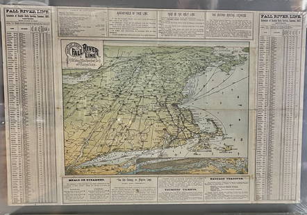
Sold2023Fall River Line, Old Colonial Railroad & Steamship Companies and CommunitiesOriginal Map. ca. 1887See Sold Price
Sold2023USGS map of Ohio – Akron Quadrangle – 1905/1926Finely printed large map of the United States Geological Survey section of Ohio that includes Akron, Barberton, Wadsworth and more. Original survey done in 1903, reprinted in 1926. Done on the polyconSee Sold Price
Sold2015Map of the Mouth of the Connecticut RiverHeading: Author: U.S. Government Title: Map of the Mouth of the Connecticut River and Saybrook Harbour. Reduced from the Original Survey of J.W. Adams, Made under the direction of Capt. W.H. Swift U.See Sold Price
Sold2018Rollup wall map entitled "Map of Ulster Country NewRollup wall map entitled "Map of Ulster Country New York" from original surveys by Oliver J. Tillson & P. Henry Brink - dated 1853. 4' 6"W x 3' 5"H. Lithographed paper applied to canvas. Slight frayinSee Sold Price
Sold2024Early 1860 school map of New York State, From New & Original surveys Under the direction of J.H.Early 1860 school map of New York State, From New & Original surveys Under the direction of J.H. French C.E.Syracuse 1860, loss on sides, foldmarks, paper on linen, map is 68.5" by 72"See Sold Price
8 hrs LeftBidhausBrown Floral Garden Design Farmhouse Decor 7X10 Wool Vintage Oriental Rug CarpetUS$10
2 days LeftAdam's AuctioneersCAREY'S General Atlas Improved and Enlarged, being a Collection of Maps of the World and Quarters,€2,600(2 bids)
6 days LeftBid Again Auctions (American Space Museum)6 - Original US Geological Survey Lunar Mosaic Map PhotographsUS$50
6 days LeftBid Again Auctions (American Space Museum)6 - Original US Geological Survey Mosaic PhotographsUS$50
6 days LeftBid Again Auctions (American Space Museum)5 - Original US Geological Survey Lunar Mosaic PhotographsUS$50
May 16Zikorn Arts & History ObjectsWest Indies, Providence, Windward, Cuba 1834 British Admiralty MapUS$100(1 bid)
May 16Zikorn Arts & History ObjectsEntrance to Baltic Great & Little Belt 1852 British Admiralty MapUS$100
May 16Zikorn Arts & History ObjectsWest Indies, Western Cuba 1879 British Admiralty Nautical MapUS$100
May 09Rail & Road AuctionsMilwaukee Road Gallatin Gateway to Yellowstone Color Advertising PosterUS$50(1 bid)


![Controller Bay Railroad Survey Map Trio [177997]: Linen backed projected location of the Kush Ta Ka Railway 28x76". 1903 blue print style 30x30", tears. 1904 Controller Bay, 30x30", small tears. Controller Bay Alaska](https://p1.liveauctioneers.com/2699/324080/174413201_1_x.jpg?height=310&quality=70&version=1711485545)


![[FOLDING MAPS] PORT BURWELL & LONG POINT, ON + 26: FOLDING MAPS. A lot of 27 folding topographical maps sold together: 2 of Ontario, 25 European. Including LARGE MAP OF PORT BURWELL & LONG POINT, ONTARIO. Original survey done in 1908 by Department of](https://p1.liveauctioneers.com/8124/322212/173235020_1_x.jpg?height=310&quality=70&version=1709937662)
![Railroad Map: Carson & Colorado Proposed 1889 Extension [170579]: Large 22"x 42" hand drawn original map on vellum map of the "Proposed Extension of the Carson & Colorado Railroad from Keeler to Mahave. The scale is four miles to the inch. The map was compiled by L.](https://p1.liveauctioneers.com/2699/299063/159201766_1_x.jpg?height=310&quality=70&version=1692045182)