Sold2022Two atlases 19th centuryTwo atlases 19th century comprising: Mitchell, S. Augustus. Mitchell's New General Atlas. Philadelphia: S. A. Mitchell, 1869. Folio (330 x 395mm), 40 (of 60) hand-coloured engraved maps, contemporarySee Sold Price
Sold2024Gordon, Patrick Geography Anatomiz'dGeography Anatomiz'd Or, The Compleat Geographical Grammar... London: Robert Morden, 1699. Second edition, 8vo in fours, 15 (of 16) maps, lacking the world map, several maps hand-coloured in outline,See Sold Price
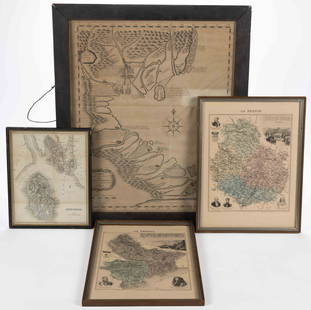
Sold2023ASSORTED EUROPEAN AND ASIAN MAPS, LOT OF FOURASSORTED EUROPEAN AND ASIAN MAPS, LOT OF FOUR, engraving on paper, three with hand-coloring, comprising a map of Buteshire in Scotland by William Home Lizars (Scottish, 1788-1859), two "LA FRANCESee Sold Price
Sold2023[MAPS]. HOMANN, Johann Baptist (1663-1724). Four engraved continent maps with hand-coloring, each[MAPS]. HOMANN, Johann Baptist (1663-1724). Four engraved continent maps with hand-coloring, each matted and framed, comprising: Totius Americae… Nuremberg, [ca 1720]. Overall sheet 508 x 590 mmSee Sold Price
Sold2019Four engraved maps of Africa.Four engraved maps of Africa. Covens and Mortier 'Carte d' Afriique' and 'Carte de la Barbarie de la Nigritie et de la Guinee'; both after W. Delisle, hand coloured in outline, 55 x 68cm; a French mapSee Sold Price
Sold2018Collection of approximately thirty hand coloured mapsCollection of approximately thirty hand coloured maps of the United Kingdom by various cartographers including Cary etc., together with fifteen various 19th Century American newspapersSee Sold Price
Sold20243 Hand Coloured Maps: Mexico / South America / Dorsetshire.3 Hand Coloured Maps: Mexico / South America / Dorsetshire.See Sold Price
Sold2019Toms & Badeslade 1742 Hand Coloured Map of Worcester"A Map of Worcestershire" Hand Coloured Copper Engraved Map Published 1742, London for "Chorographia Britanniae, or a set of maps of all the counties in England and Wales" by Thomas Badeslade & WilliaSee Sold Price
Sold2018Wyld, James C1840 Group of 4 Hand Coloured MapsIncl Spain/Portugal, Syria, Asia and Turkey in Asia. Hand Coloured Steel Engraved Map Published C1840, London for "Atlas of Modern Geography" by James Wyld. Centre fold as published. Paper Size: 11 xSee Sold Price
Sold2018Small Robert Morden antique hand coloured map ofSmall Robert Morden antique hand coloured map of Middlesex, together with a set of six framed maps of the United StatesSee Sold Price
Sold20201738 MAP OF EGYPT W/ LYBIA (HAND COLOURED MAP BY1738 MAP OF EGYPT W/ LYBIA (HAND COLOURED MAP BY D/ANVILLE)See Sold Price
Sold2018Framed antique hand coloured map of the Isle of WightFramed antique hand coloured map of the Isle of WightSee Sold Price
Sold2023Seutter Antique Hand Coloured Map of JamaicaMatthaeus Seutter (1678-1756) Antique Hand Coloured Map of Jamaica Titled Nova Designatio Insulae Jamaicae. Map measures 20 inches H x 23 within matting, frame measures 28 x 31 inches.See Sold Price
Sold2024Map: A 17thC engraved and hand coloured map of Scotland titled Strath-Navernia / Strath Navern afterMap: A 17thC engraved and hand coloured map of Scotland titled Strath-Navernia / Strath Navern after Blaeu. Signed in pencil lower. Approx. 17" x 20 1/2" Please Note - we do not make reference to theSee Sold Price
Sold2019Moll, Herman 1724 Hand Coloured Map of Somerset"Somersetshire" Hand Coloured Copper Engraved Map Published 1724, London for "A New Description of England and Wales" by Hermann Moll. Paper Size: 12.5 x 8 inch (32 x 20cm) A few discrete wormholes, oSee Sold Price
Sold2022Robert Morden, a hand-coloured map of Shropshire, 14" x 17", unframed, along with a further handRobert Morden, a hand-coloured map of Shropshire, 14" x 17", unframed, along with a further hand coloured map of Shropshire published by Pigot and Co, 15" x 10", both unframed.See Sold Price
Sold2019Kitchin, Thomas C1780 Hand Coloured Map of Worcester"Worcestershire Drawn from the best authorities" Hand Coloured Copper Engraved Map by Thomas Kitchin. Published London, C1780. Probably from The Antiquities of England and Wales by Francis Grose, or sSee Sold Price
Sold2019Clarke & Bingley 1824 Hand Coloured Map of MexicoHand Coloured Copper Engraved Map Published 1814-24, London for "A New Geographical Dictionary; Containing a Description of all the Empires, Kingdoms, States and Provinces..." by J. W. Clarke. EngraveSee Sold Price
Sold2019Clarke & Neele 1823 Hand Coloured Map of Europe"A Map of Europe, as settled by the Congress at Vienna, in 1815" Hand Coloured Copper Engraved Map Published 1814-24, London for "A New Geographical Dictionary; Containing a Description of all the EmpSee Sold Price
Sold2024Rare Hand-coloured Map - Florida - Louisiana - United States - BellinIts finely engraved, hand-coloring engraved map from the Dutch edition of acques Nicolas Bellin "Histoire General of Travel". Published in Amsterdam, 1770 year. Carte de la Floride de la LouSee Sold Price
Sold2023Ulisse Aldrovandi (Italian, 1522-1605)Ulisse Aldrovandi (Italian, 1522-1605) Ulisse Aldrovandi (Italian, 1522-1605) a set of four hand-coloured engravings of birds, taken from 'Ornithologiae hoc est de avibus Historiae libri XII' image 32See Sold Price
Sold2023After William Hogarth, 18th century The Four Times of the Day (Morning, Noon, Evening & Night) a setAfter William Hogarth, 18th century The Four Times of the Day (Morning, Noon, Evening & Night) a set of four hand-coloured engravings on laid paper 35.5 x 25cm (Pl.), in period frames; together with NSee Sold Price
Sold2022France.- Manuscript estate maps.- Marche (Lecoy de la) [Survey of the estates of Château-France.- Manuscript estate maps.- Marche (Lecoy de la) [Survey of the estates of Château-Renault], manuscript, double-page preface and 2 tables, 9 double-page hand-coloured maps (numbered 2-10, aSee Sold Price
Sold2021[MAPS] WYLD, JAMES. A LOT OF 20 MAPS[MAPS] WYLD, JAMES. A lot of 20 maps, including: [WYLD, James] A lot of 20 pieces, Engraved title and 19 engraved hand coloured maps. Sold as acollection. London: Thomas Tegg, c.1826- 1860. Approx. 20See Sold Price
May 08Jasper52GUADELOUPE. Marie-Galante, Désirade, Iles des Saintes.Vuillemin. 1903 old mapUS$15
Featured7 hrs LeftJasper52Océanique. Iles Radak et Iles Ralik #10. Marshall Islands. VANDERMAELEN 1827 mapUS$75
7 hrs LeftJasper52Océanique Iles de la Société #42 Tahiti Rangiroa Polynesia VANDERMAELEN 1827 mapUS$85
7 hrs LeftJasper52Océanique Partie… des Iles Basses 48 SE Tuamotus Polynesia VANDERMAELEN 1827 mapUS$50
7 hrs LeftJasper52Océanique. Archipel des Nouvelle Hébrides #39. Vanuatu. VANDERMAELEN 1827 mapUS$85
May 08Jasper52Amér. Mér. Guyane Anglaise #4 bis. Guyana Suriname. VANDERMAELEN 1827 old mapUS$30
7 hrs LeftJasper52Océanique. Partie des Iles Carolines #8. Palau Micronesia. VANDERMAELEN 1827 mapUS$40
7 hrs LeftJasper52Océanique. Partie… Iles Mariannes #2 North Mariana Islands VANDERMAELEN 1827 mapUS$40
7 hrs LeftJasper52Océanique. Partie des Iles Carolines #8. Palau Micronesia. VANDERMAELEN 1827 mapUS$40
7 hrs LeftJasper52Océanique. Partie… Iles Mariannes #2 North Mariana Islands VANDERMAELEN 1827 mapUS$40
May 08Jasper52Amér Sep Grandes Antilles 73 Jamaica Pedro Bank San Andrés VANDERMAELEN 1827 mapUS$45
7 hrs LeftJasper52Océanique. Partie des Iles Carolines #9. Yap Micronesia. VANDERMAELEN 1827 mapUS$50
7 hrs LeftJasper52Océanique. Partie des Iles Carolines #9. Yap Micronesia. VANDERMAELEN 1827 mapUS$50
7 hrs LeftJasper52Océanique Partie… des Iles Basses 48 SE Tuamotus Polynesia VANDERMAELEN 1827 mapUS$50
7 hrs LeftJasper52Océanique. Iles des Navigateurs #41 Samoa & American Samoa VANDERMAELEN 1827 mapUS$60
7 hrs LeftJasper52Océanique. Partie… des Iles Basses #49 Gambiers Polynesia. VANDERMAELEN 1827 mapUS$60
7 hrs LeftJasper52Océanique. Archipel de Mendana #34. Marquesas Polynesia. VANDERMAELEN 1827 mapUS$60
7 hrs LeftJasper52Océanique. Archipel de Mendana #34. Marquesas Polynesia. VANDERMAELEN 1827 mapUS$60
7 hrs LeftJasper52Océanique. Partie… des Iles Basses #49 Gambiers Polynesia. VANDERMAELEN 1827 mapUS$60
7 hrs LeftJasper52Océanique. Iles des Navigateurs #41 Samoa & American Samoa VANDERMAELEN 1827 mapUS$60
7 hrs LeftJasper52Océanique Partie… des Iles Basses 43 NE Tuamotus Polynesia VANDERMAELEN 1827 mapUS$65
7 hrs LeftJasper52Océanique. Partie des Iles Salomon #33. Solomon Islands. VANDERMAELEN 1827 mapUS$65
7 hrs LeftJasper52Océanique. Partie des Iles Salomon #33. Solomon Islands. VANDERMAELEN 1827 mapUS$65


![[MAPS]. HOMANN, Johann Baptist (1663-1724). Four engraved continent maps with hand-coloring, each: [MAPS]. HOMANN, Johann Baptist (1663-1724). Four engraved continent maps with hand-coloring, each matted and framed, comprising: Totius Americae… Nuremberg, [ca 1720]. Overall sheet 508 x 590 mm](https://p1.liveauctioneers.com/197/284572/150193668_1_x.jpg?height=310&quality=70&version=1680880467)


![France.- Manuscript estate maps.- Marche (Lecoy de la) [Survey of the estates of Château-: France.- Manuscript estate maps.- Marche (Lecoy de la) [Survey of the estates of Château-Renault], manuscript, double-page preface and 2 tables, 9 double-page hand-coloured maps (numbered 2-10, a](https://p1.liveauctioneers.com/5458/260724/135800184_1_x.jpg?height=310&quality=70&version=1662479034)
![[MAPS] WYLD, JAMES. A LOT OF 20 MAPS: [MAPS] WYLD, JAMES. A lot of 20 maps, including: [WYLD, James] A lot of 20 pieces, Engraved title and 19 engraved hand coloured maps. Sold as acollection. London: Thomas Tegg, c.1826- 1860. Approx. 20](https://p1.liveauctioneers.com/1124/208511/106199218_1_x.jpg?height=310&quality=70&version=1624388585)


