Sold2024Howard Miller MC Electric World Clock, USA 1959Howard Miller Clock Co Model 612-371 World Time Light up Map Clock encased in Solid Oak Wood. signed on clock with original label on backside. Made in USA with patent number. ca. 1959 with copyright.See Sold Price
Sold2022LARGE LOT OF 11 ALBUMS OF U.S.A. MINT STAMPS.This lot includes: an album of 1958 - 1961 plate blocks, about 110; an album of 1938 - 1948 plate blocks, about 85; an album of 1949 - 1959 plate blocks, about 98; an album of 1962 - 1968 plate blocksSee Sold Price
Sold2023Bodil Kjær - Executive Desk, model 901Lot 193 Bodil Kjær Danish (b. 1932) Executive Desk, model 901 (1959) rosewood and chromed-plated steel manufactured by CI Designs, Boston, USA with four drawers to one side manufacturer's stamp toSee Sold Price
Sold2020Some Like It Hot (USA, 1959) US Insert Movie PosterSome Like It Hot (USA, 1959) US Insert Movie Poster When two male musicians witness a mob hit, they flee the state in an all-female band disguised as women, but further complications set in. Director:See Sold Price
Sold2017Drexel, Declaration table set, USA, 1959, walnut, blackDrexel, Declaration table set, USA, 1959, walnut, black laminate, each with stamped marks and date, four small tables fit neatly under the large table, large: 38"sq x 16.5"h; four small: 18"sq x 15"hSee Sold Price
Sold2022Emanuel Bowen Map USA Eastern Seaboard 1740s New YorkEmanuel Bowen, map of United States Eastern Seaboard, Emanuel Bowen (British, 1694-1767), "A New and Accurate Map of New Jersey, Pennsylvania, New York, and New England", c. 1744, from Maryland to NovSee Sold Price
Sold2023Antique Map - USA - Port of Boston - North Atlantic Ocean - Marco ColtelliniTitle: Antique Map - USA - Port of Boston - North Atlantic Ocean - Marco Coltellini Date/Period: 1763 Dimensions: 24 cm x 31 cm Material: Paper Additional Information: This wonderful engraving " CartaSee Sold Price
Sold2023Russell & Barclay 1840 Hand Col Map. USA showing Franklinia State"States of America" showing the State of Franklinia. First published around 1820, this dated 1840 with superb original hand colour and a good impression. Hand Colored Copper Engraved Map Published 182See Sold Price
Sold2023Baines, Edward 1817 Antique Map. USA & Canada, War of 1812"United States of America Exhibiting the Seat of War on the Canadian Frontier" Copper Engraved Map Published 1817, London for "History of the Wars of the French Revolution..." by Edward Baines. FoldsSee Sold Price
Sold2017National Broadcasting Company STAMP, USA 1940 'sThis is an authentic vintage all metal ink stamping block. It was used by NBC radio in the 1940s and prints their logo. It stamps a 1 'square and is 5/8 'tall. Quite a rare find for Radio Buffs worldwSee Sold Price
Sold2019U S Coast Survey 1896 Map. USA - Telegraphic Stations"Base Map of the United States" by W. W. Duffield. Telegraphic Stations. Lithograph Map Published 1896, Washington for "U.S. Coast and Geodetic Survey" Folds as issued. Rare. Paper Size: 30 x 24 inchSee Sold Price
Sold2022Times Atlas 1895 Pair of Maps. USALithograph Map Published 1895, London for "The Times Atlas" Paper Size: 16 x 10 inch (41 x 26cm) Good ConditionSee Sold Price
Sold2022Times Atlas 1895 Lot of 4 Maps. USA & North AmericaLithograph Map Published 1895, London for "The Times Atlas" Two with Centre fold as published. Up to Paper Size: 21 x 16 inch (53 x 41cm) One with small split on centre fold, otherwise Good ConditionSee Sold Price
Sold2022Designed Chinese/Asian Stamps MapHand made Chinese/Asian stamps on cardboard map. 11.5inch L, 9.1inch W.See Sold Price
Sold20234 Binders of Asst Stock Book Stamps - USA, Great Britain, Ireland, Germany, Greenland, Korea, Japan,4 Binders of Asst Stock Book Stamps - USA, Great Britain, Ireland, Germany, Greenland, Korea, Japan, Russia, Rwanda + Much MoreSee Sold Price
Sold2022USA Stamps USA Stamps, album not completely full Review images and description for condition.USA Stamps, album not completely full Review images and description for condition.See Sold Price
Sold2020Vintage Road Maps, USA & Europe (50)Texaco, Chevron, Gulf, Standard Oil, Esso, Regent, Mobil, Standard Oil, Exxon, Caltex, Amoco, Cities Service & SinclairSee Sold Price
Sold2019Gross, Alexander 1920 Lot of 9 Large Maps. USALarge Lithograph Maps Published 1920, London for "The Daily Telegraph Victory Atlas of the World" by Alexander Gross. Centre fold as published. Paper Size: 25 x 19.5 inch (64 x 49cm) Good ConditionSee Sold Price
Sold2023Bartholomew, John 1922 Mixed Lot of 5 Large Maps. USA, North America & IndiaNorth America Political, United States - Central and North Eastern States, India North East and the Ganges Valley. Large Lithograph Maps Published 1922 by The Times, London for "The Times Survey AtlasSee Sold Price
Sold2022National Encyclopedia 1891 Lot of 3 Maps. USA, North AmericaLithograph Maps Published 1891-1901 by William Mackenzie, London for "The National Encyclopedia: A dictionary of Universal Knowledge" Center fold as issued. Paper Size: 12 x 9.5 inch (31 x 24cm) GoodSee Sold Price
Sold2020Bartholomew, John 1922 Lot of 6 Large Maps. USAIncl North America Political, USA - East, USA - Central, USA - West, North East States, and Sketch Plans of American Cities. Large Lithograph Maps Published 1922 by The Times, London for "The Times SuSee Sold Price
Sold2019The Times 1895 Lot of 5 Maps. USA & CanadaLithograph Maps Published 1895, London for "The Times Atlas" Paper Size: 16 x 10.5 inch (41 x 27cm) and 21 x 16 inch (54 x 41cm) Good ConditionSee Sold Price
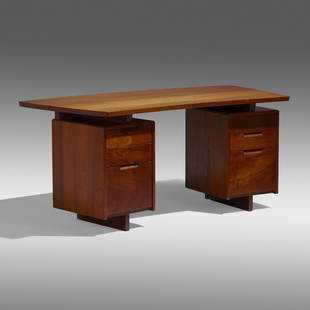
Sold2022George Nakashima, Rare Double Pedestal deskGeorge Nakashima Rare Double Pedestal desk Nakashima StudioUSA, 1959East Indian teak 29 h × 65.75 w × 31.5 d in (74 × 167 × 80 cm) Desk features a four plank topSee Sold Price
22 hrs LeftJasper52World War 2. Guadalcanal Campaign. October & November 1942 Operations 1959 mapUS$10
22 hrs LeftJasper52World War 2. Guadalcanal Campaign 7-8 Aug 1942 Tulagi Landing Schedule 1959 mapUS$10
22 hrs LeftJasper52World War 2. Guadalcanal Campaign. August & September 1942 Operations 1959 mapUS$10
22 hrs LeftJasper52World War 2. Guadalcanal Campaign 7-8 Aug 1942 Landing. Henderson Field 1959 mapUS$10
22 hrs LeftJasper52World War 2. Guadalcanal Campaign. Landing 7 Aug 1942 & Concurrent Ops 1959 mapUS$10
22 hrs LeftJasper52Pacific Ocean sea chart. Ports lighthouses mail routes dockyards LARGE 1959 mapUS$35