Sold2016Japanese Old mapJapanese old map / Japanese old map /Wood Block Print (1850~1910 ?) / very large / size 113 1/2" x 14 1/2"See Sold Price
Sold2015Map of Asia. Print in 1850.Map of Asia Since the death Chingiz Khan in 1227 - 1849. Print in 1850.Print of steel engraving titled „L‘Asie Depuis la mort se Tchinghiz-Khan. De la preponderance des Anglais 1227 - 1849“.AuthSee Sold Price
Sold2015Map of Asia. Print in 1850.Map of Asia At the time of Alexandre the Great in 322. Print in 1850.Print of steel engraving titled „L‘ Asie A L‘Epoque D‘ Alexandre le Grand L‘ an 322“.Author A. Houze.Engraved by unknowSee Sold Price
Sold2015Map of Palestine. Print in 1850.Print of steel engraving titled „Carte de la Palestine sous Constantin le Grand 33 apres J. C.“.Author A. Houze.Engraved by unknown.From the „Atlas Universel Historique et Geographique“ by A.See Sold Price
Sold2015Map of the Holy Land. Print in 1850.Map of the Holy Land since the Second Crusade in 1149 - 1291. Print in 1850.Print of steel engraving titled „Carte de la Terre Sainte depuis la deuxieme Croisade jusqua la fin de la domination ChretSee Sold Price
Sold2015Map of the Holy Land. Print in 1850.Map of the Holy Land divided into Kingdoms of Israel and Judahin 975 - 588 J.C. Print in 1850.Print of steel engraving titled „Carte de la Terre Sainte divisee en Royaumes D‘Israel et de Juda de 9See Sold Price
Sold2015Map of travels of Israelites. Print in 1850.Print of steel engraving titled „Carte du voyages des Israelites “.Author A. Houze.Engraved by unknown.From the „Atlas Universel Historique et Geographique“ by A. Houze, Paris. 1850.The IsraelSee Sold Price
Sold2015Map of North America in 1846. Print in 1850.Print of steel engraving titled „Amerique Septentionale en 1846“.Author A. Houze.Engraved by unknown.From the „Atlas Universel Historique et Geographique“ by A. Houze, Paris. 1850.North AmericSee Sold Price
Sold2015Map of South America in 1849. Print in 1850.Print of steel engraving titled „Amerique Meridionale en 1849“.Author A. Houze.Engraved by unknown.From the „Atlas Universel Historique et Geographique“ by A. Houze, Paris. 1850.South AmericaSee Sold Price
Sold2015Map of the Garden of Eden. Print in 1850.Map of the Garden of Eden after D. Calmet. Print in 1850.Print of steel engraving titled „Carte du Paradis Terestre suivant D. Calmet “.Author A. Houze.Engraved by unknown.From the „Atlas UniverSee Sold Price
Sold2015Map of France in 1270 - 1328. Print in 1850.Print of steel engraving titled „La France a la mort de Charles IV Tit le Belt de 1270 a 1328“.Author A. Houze.Engraved by unknown.From the „Atlas Universel Historique et Geographique“ by A. HSee Sold Price
Sold2015Map of Asia At the time of Chingiz - Khan.Map of Asia At the time of Chingiz - Khan in 1226. Print in 1850.Print of steel engraving titled „L‘ Asie A L‘Epoque de Tchinghiz - Khan L‘ an 1226“.Author A. Houze.Engraved by unknown.FromSee Sold Price
Sold2015Map of Greece and part of Asia Minor. Print in 1850.Print of steel engraving titled „La Grece et partie de l‘Asie Mineure“.Author A. Houze.Engraved by unknown.From the „Atlas Universel Historique et Geographique“ by A. Houze, Paris. 1850.GreeSee Sold Price
Sold2015Map of Ancient Greece and Italy in 900 - 1002.Map of Ancient Greece and Italy in 900 - 1002. Print in 1850.Print of steel engraving titled „L‘Empire Grec, L‘ Italy 900 - 1002“.Author A. Houze.Engraved by unknown.From the „Atlas UniverseSee Sold Price
Sold2015Map of Ottoman Empire and Italy in 1400 - 1500.Map of Ottoman Empire and Italy in 1400 - 1500. Print in 1850.Print of steel engraving titled „L‘Empire Ottoman apres la prise de Constantinople L‘Italie a l‘epoque de l‘asservissement des VSee Sold Price
Sold2017Slavery and Slave Trade 1830 - 1850 mapUnknown. Slavery and Slave Trade 1830 - 1850. Slavery and Slave Trade 1830 -1850. Framed. Medium: Print. Size: 6.5" X 8.5". Signature: Unsigned.See Sold Price
Sold2016Hawaiian & Pacific Polynesian Islands, Australia, 1850Original engraving by Samuel Augustus Mitchell from Mitchell’s Universal Atlas, 1850. Map highlights the Pacific ocean & surrounding islands; Hawaii, Polynesian, Australia & New Zealand. Dimensions:See Sold Price
Sold2018Oversized Industrial Commercial Oak Map Print CheOversized Industrial Commercial Oak Map Print Chest. Metal handles, panel sides. Antique.-- Dimensions: H: 65.5 inches: W: 63 inches: D: 25 inches ---See Sold Price
Sold2017German Moscovia Map PrintTitled "Mosvavw", hand colored, note on verso "Braun and Hogenburg, Cologne c. 1585 The earliest obtainable map or view of Moscow". Map, 15-1/2" x 21", framed 22-1/2" x 28"See Sold Price
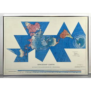
Sold2023Richard Buckminster Fuller Dymaxion World Map Print, 1980 FullerRichard Buckminster Fuller Dymaxion World Map Print, 1980 Fuller Dimensions: H: 22.5 inches: W: 34.5 inches --- -- We offer curbside delivery to NYC, Manhattan, Close Brooklyn, Hoboken about a week afSee Sold Price
Sold2020Norddeutscher Lloyd Bremen Ocean Liner Map PrintNorddeutscher Lloyd Bremen Ocean Liner Map Print framed under ship with steamships Munchen and Columbus. Measurements in inches: 45 x 33, Image: 39 x 27 Condition:Some wear to frame, print is clean ShSee Sold Price
Sold2021RINGGOLD - Bay of San Francisco Map 1850RINGGOLD, Cadwalader (1802-1867, surveyor). Chart of the Bay of San Pablo Straits of Carquines and part of the Bay of San Francisco California by ... Ringgold assisited by Simon F. Blunt ... ProjectedSee Sold Price
Sold201819C Oak Map Print Paper Collector's Case CabinetUnited States,Late 19th Century Six long drawers with bin pulls on a molded base, used for holding works on paper including maps and blueprints. Oak 57" x 36" x 32", From an Exeter, Rhode Island estatSee Sold Price
Sold20193pc Stacking Industrial Metal Map Print Cabinet.3pc Stacking Industrial Metal Map Print Cabinet. Gray metal 5 drawer sections. Some drawers are lined. Silver chrome pulls. Marked HAMILTON.-- Dimensions: H: 49.75 inches: W: 41 inches: D: 29.5 inchesSee Sold Price
7 days LeftJasper52Carte de L'Algérie et de la Régence de Tunis' ANDRIVEAU-GOUJON Algeria 1850 mapUS$100
6 hrs LeftRapid Estate Liquidators and Auction GalleryVintage Framed Cat Island Nautical Map PrintUS$55
3 days LeftRoyal Treasures Warehouse LLCIndians of the USA Native American Tribes Historical Map PosterUS$50(1 bid)
7 days LeftJasper52Gambian birds. Monoceros. A bird with four wings. CHILD 1745 old antique printUS$10
7 days LeftJasper52West Africa. Liberia Sahara Senegambia Guinea. Mountains of Kong COLTON 1869 mapUS$20
7 days LeftJasper52Algeria Morocco & Tunis. North Africa. Tunisia. Maghreb. BARTHOLOMEW 1898 mapUS$20