Sold20201898 Atlas of Worcester CountyDisbound - Edge Wear on some plates - Most in good condition - Listing of businesses, farms, etc.See Sold Price
Sold20232PC Massachusetts & Kansas AtlasesUnited States,Early 20th Century Includes a "Lord's Indexed Street Atlas of Bristol County Massachusetts," published by Harry D. Lord, and a "Plat Book of Saline County Kansas" published by the NorthwSee Sold Price
Sold2018LivoniaTitle/Content of Map: Livonia Cartographer: HONDIUS, JODOCUS/GERARD MERCATOR Height (inches): 14.3 Width (inches): 18.75Year: 1630 Mercator plate from Hondius's atlas.Original color. Text in Latin onSee Sold Price
Sold2021Hastings Dobbs’ Ferry Irvington Map Engraving 1872Hastings, Dobbs’ Ferry, Irvington Engraving, 1872, no apparent signature, verso reads ‘(40) Original Map Westchester County Atlas, 1872’, subject maps of the towns of Hastings, Dobbs’ Ferry, aSee Sold Price
Sold2022Atlas of Cuyahoga County, R.H.Wade and J.H.WadeAtlas of Cuyahoga County, Plates 94 and 95, Residences of R.H.Wade and J.H.Wade, ESQ'S, Euclid Avenue, Cleveland, Ohio, hand colored lithograph, matted and framed in Bird's eye maple frame. DSee Sold Price
Sold20221899 Bristol County Book1899 Our County and Its People Descriptive & Biological Record of Bristol County, Massachusetts. Prepared & Published by Fall River News and Taunton Gazette. Binding has tears. Overall good condition.See Sold Price
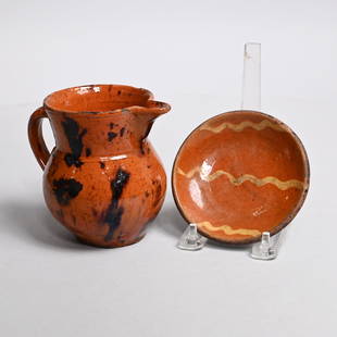
Sold2022American Glazed Redware Pitcher and Plate, C. 1840The first probably Bristol County, Massachusetts or Norwalk, Connecticut, medium red clay covered in speckled orange-brown glaze daubed in manganese brown; the miniature dish probably Norwalk, ConnectSee Sold Price
Sold20231891 George Walker Massachusetts Atlas Plate No. 10 Map of Nantucket1891 George Walker Massachusetts Atlas Plate No. 10 Map of Nantucket, copyright 1891 G.H. Walker & Co. Boston, Mass, showing Nantucket, Nantucket Sound, Tuckernuck and Muskeget Islands. Sight 19 iSee Sold Price
Sold2020plate, mass on cardboard plates, 4.5-5.5 cm, inplate, mass on cardboard plates, 4.5-5.5 cm, in original box, along with it 1 bear head for a hunting room German Description Gerichteteller, Masse auf Pappteller, 4,5-5,5 cm, im Orig.-Kart., dazu 1 BSee Sold Price
Sold2020TEXAS MAP ENGRAVING PANHANDLE COUNTIES INSETFramed Texas map, hand-colored engraving on paper, a page from an atlas, plate 68, published by William Bradley, c.1880, an inset with Panhandle counties, within a geometric border, sight: approx 17.5See Sold Price
Sold2023Wedgwood Blue Jasperware Biscuit JarCapern's Birds pattern. On wooden pedestal. E.P.N.S. lid marked for Parsons Bristol. Tarnishing and tape residue to plate. Original flaws to one side of the bird decoration, popped glaze and cracked bSee Sold Price
Sold20221876 Norfolk County Atlas Published by Comstock and Clinesome wear, overall good condition. Some pages have edge damage. Cover has wear. Please see photos and come to the 2 day preview for condition.See Sold Price
Sold2017Canaan Map The Bible AtlasMap: Canaan. The Bible Atlas. Palmer, Richard. The Bible Atlas. This plate: Canaan. New York, 1836. Original lithograph with hand coloring. Sheet size: 8 1/4 x 5 in. Please note that this lot has a coSee Sold Price
Sold2015Town of Dover in Dutchess County, Atlas of New York byOriginal steel engraving by Augustus Mitchell, 1881. Map features city streets & railroads. Dimensions: 15” x 12”See Sold Price
Sold2015Town of Pawling in Dutchess County, Atlas of New YorkOriginal engraving from Atlas of New York by Beers, 1867. Dimensions: 17" x 14 1/2"See Sold Price
Sold2022American Federal Mirror With Eglomise Panel of Eagle.39 x 21 inches, with original mirror plate. Note on the back reads "I purchased this mirror in Groton, Mass. Hopkins family. Original glue blocks on mirror and panel. The back has shrunk and several sSee Sold Price
Sold20221875 Atlas of Middlesex County Published by F.W. BeersGood condition with light wear. Please see photos and come to the 2 day preview for condition.See Sold Price
Sold20241909 Atlas of Benton County IndianaStandard Atlas of Benton County Indiana by George A. Ogle & Co, Chicago. Maps of the Villages, Cities and Townships of the County. Cover has wear with loose binding. Pages have little wear with some sSee Sold Price
Sold2018Catalogue of Rare Chinese Jade Carvings ~ NottA Catalogue of Rare Chinese Jade Carvings Introduction by Lieut. General Sir Sydney Lawford, K.C.B. Illustrated by Fourty four plates from Original Photographs.See Sold Price
Sold2021Original John Hancock Signed Military Document1790 Document appointing Thomas Lincoln to Captain of the Third Regiment in the British Brigade and Fifth Division of Militia in the counties of Plymouth, Barnstable, Bristol and Dukes County along wiSee Sold Price
Sold2022AUGUSTA CO., SHENANDOAH VALLEY OF VIRGINIA ATLASAUGUSTA CO., SHENANDOAH VALLEY OF VIRGINIA ATLAS, "Historical Atlas of Augusta County, Virginia. Maps From Original Surveys, by Jed Hotchkiss. Its Annals, by Joseph A. Waddell. Physiography, by Jed HoSee Sold Price
Sold2023Original Robert Mills Atlas Map of Fairfield District1825 printing in nice well preserved condition. Some pink watercoloring to the border of the county as well. Slight yellowing to paper consistent with age. Full margins having not been framed, laid doSee Sold Price
Sold2022Ridgewood Fine China Bucks County Collectable PlateRidgewood Collectable Fine China plate that shows the map of Burks County from 1600-1800. The map shows famous events and areas along with the original seal and William Penn (Who along with originallySee Sold Price
Sold202319th century. A clean original Julius & Bien CO, NY map of the USA Boundaries of the Union and19th century. A clean original Julius & Bien CO, NY map of the USA Boundaries of the Union and Confederates Geographical Divisions and Departments, June 30, 1864. Plate CLXIX. Atlas to accompany the oSee Sold Price
Jun 13Swann Auction Galleries(CAPE COD.) Albert F. Poole. Bird's Eye View of the Village of Hyannis, Barnstable County, Mass.US$1,100
Jun 13Swann Auction Galleries(NEW JERSEY.) Group of 2 mid-nineteenth-century wall maps of Garden State counties.US$600
Jun 13Swann Auction Galleries(NEW JERSEY.) Group of 3 mid-nineteenth-century wall maps of Garden State counties.US$900
Jun 13Swann Auction Galleries(NEW YORK CITY.) David Burr. Map of the City and County of New York with the Adjacent Country.US$2,200
Jun 13Swann Auction Galleries(PHILADELPHIA -- ROXBOROUGH/MANAYUNK.) John Levering. Plan of the Township of RoxboroughUS$500
Jun 13Swann Auction Galleries(NEW YORK.) Amos Lay. Map of the State of New York with Part of the States of Pennsylvania, NewUS$500
Jun 13Swann Auction Galleries(NEW JERSEY.) William Kitchell; and Robert Pearsall Smith. Topographical Map of the State of NewUS$600
Jun 13Swann Auction Galleries(GEOGRAPHY.) Karl Joseph Kipferling. Kleiner Atlas Der Neuen Geographie zum Gebrauche derUS$450
Jun 13Swann Auction Galleries(GEOGRAPHY.) Rigobert Bonne; and Guillaume Thomas Francois Raynal. Atlas de Toutes les PartiesUS$450
Jun 13Swann Auction Galleries(TITLE PAGES.) Group of 10 seventeenth-and-eighteenth-century engraved allegorical atlas titleUS$600
Jun 13Swann Auction Galleries(SDUK.) Society for the Diffusion of Useful Knowledge. [Composite atlas of international city plans,US$1,500
Jun 13Swann Auction GalleriesLUCAS, FIELDING. A General Atlas Containing Distinct Maps of All the Known Countries in the World.US$6,000
Jun 13Swann Auction Galleries(FRANCE and SWITZERLAND.) Johannes Blaeu. Geographiae Blauianae Volumen Septimum, quo Liber XIV, XVUS$3,000


![(KOREAN ATLAS.) Ch'onha Chido [Atlas of all under Heaven]. (1 of 2)](https://p1.liveauctioneers.com/199/332329/179231728_1_x.jpg?height=282&quality=70&version=1717450360)


![(KOREAN ATLAS.) Ch'onha Chido [Atlas of all under Heaven]. (1 of 4)](https://p1.liveauctioneers.com/199/332329/179231729_1_x.jpg?height=282&quality=70&version=1717450360)


