Sold2016[World Map]. Rumold Mercator. Orbis terrae compe[World Map]. Rumold Mercator. Orbis terrae compendiosa descriptio.&See Sold Price
Sold2020MERCATOR, RUMOLD. Orbis Terrae Compendiosa Descriptio.MERCATOR, RUMOLD. Orbis Terrae Compendiosa Descriptio. Double-page engraved double-hemispheric world map. 14½x21 inches sheet size, upper and lower margins wide, others narrow, French text on verSee Sold Price
Sold2020Mercator World Map*** START PRICE IS THE RESERVE *** [World] MERCATOR, Rumold (1545-1599). Orbis Terrae Compendiosa Descriptio Quam ex Magna Universali Mercatoris... Engraved Map with original hand color. Geneva, 1587.See Sold Price
Sold2023Mercator, Rumold (1545-1599) World MapAn engraved double-page double hemispheric world map, "Orbis Terrae Compendiosa Descriptio". Dimensions:Sight is 11 1/4" x 20 3/4", the frame 21" x 29 1/2". Provenance:From a Philadelphia Collection.See Sold Price
Sold2024Gerard Mercator (Belgian 1512 - 1594) and Rumold Mercator (Belgian 1545 - 1599)Gerard Mercator (Belgian 1512 - 1594) and Rumold Mercator (Belgian 1545 - 1599) "Orbis Terrae Compendiosa Descriptio", circa 1595 Engraved and hand colored map 14 1/2" x 19 3/4" Condition: aging, yellSee Sold Price
Sold2022World.- Plancius (Petrus) Orbis Terrarum Typus de Integro Multis in Locis Emendatus auctore PetroWorld.- Plancius (Petrus) Orbis Terrarum Typus de Integro Multis in Locis Emendatus auctore Petro Plancio, double-hemisphere world map, after Mercator's world map of 1587, and the first map to show JaSee Sold Price
Sold2016Mercator's double-hemisphere world 1587Heading: Author: Mercator, Rumold Title: Orbis terrae compendiosa descriptio: quam ex magna universali Gerardi Mercatoris Domino Richardo Gartho, geographie ac aeterarum bonarum artium amatori ac fauSee Sold Price
Sold2024Abraham Ortelius Map Of WalesOrtelius' map is the first printed map of Wales, appeared in Ortelius' Theatrum Orbis Terrarum, the first modern atlas of the world. The map is based upon Mercator's 1564 wall map of the British IslesSee Sold Price
Sold2022MAP, Africa, MercatorFull Contemporary Color. Africa. Gerard Mercator, Africa ex Magna Orbis Terre Descriptione Gerardi Mercatoris Desumpta, Studio & Industria, from Atlas sive Cosmographicae..., 1609 (circa). Hand Color.See Sold Price
Sold20211613 America sive India Nova ad magnae GerardiBy: Michael MercatorDate: 1613 / DuisbergDimensions: 16 x 19.5 inches (40.7 x 49.5 cm)This is an authentic antique map of the Western Hemisphere by Michael Mercator. The map is based on Rumold MercatoSee Sold Price
Sold20191763 d'Anville Ancient World Map -- Orbis VeteribusTitle/Content of Map: 1763 d'Anville Ancient World Map -- Orbis Veteribus Notus Auspiciis Serenissimi Principis Ludovici Philippi Aurelianorum Ducis Publici Juris Factus Date: 1763, London CartographeSee Sold Price
Sold20221763 d'Anville Ancient World Map -- Orbis Veteribus Notus Auspiciis Serenissimi Principis LudoviciTitle: 1763 d'Anville Ancient World Map -- Orbis Veteribus Notus Auspiciis Serenissimi Principis Ludovici Philippi Aurelianorum Ducis Publici Juris Factus Cartographer: J d'Anville Year / Place: 1763,See Sold Price
Sold2017Thomson: Antique World Map, Mercator's Projection, 1814Map: Chart of the World on Mercator's Projection Cartographer: Thomson Place & Date: Edinburgh / 1814 Size: 20" x 17 3/4" Condition: b&w; overall age toning; browning along centerfold; two small, repaSee Sold Price
Sold2024Nicolaes Van Geelkercken, 1632 world mapNicolaes Van Geelkercken, 1632 world map, Orbis Terrarum Descriptio Duobis Planis Hemisphaeriis Comprehesa, hand-colored engraving, 20th c. restrike, matted and framed under glass, 17"h x 23"w (sight)See Sold Price
2023Early World Map "Typvs Orbis Terrarvm" Hand ColorDated 1590 near bottom legend box. Hand colored, with red and orange watercolor prominent in the titles. Blue clouds in border. Some slight use of yellow in the boundaries of the map. With signature oSee Sold Price
Sold2017Launay World Map - Typus Orbis Terrarum, 1720Map: Launay World Map - Typus Orbis Terrarum Cartographer: C. Launay Date: ca. 1720 Size: 5 x 8 inches A quite rare, unique and charming double hemisphere map showing very rough approximations for theSee Sold Price
Sold2020A World Map on Mercator's ProjectionA World Map on Mercator's Projection George F. Cram Co., Chicago, 19th/20th Century 17 7/8 x 26 1/8 inches (visible). Property from a Corporate Art CollectionSee Sold Price
Sold2017Tallis World Map World on Mercator's Projection 1851Tallis World Map The World on Mercator's Projection 1851 . J. Tallis, 1851 London, 10.5 X 14 In.. This Is a Decorative and Striking Steel Engraved World Map That Was Produced from the Same Plate UsedSee Sold Price
Sold2022Africa.- Ortelius (Abraham) Africae Tabula Nova, engraved map, [c.1570-1612].Africa.- Ortelius (Abraham) Africae Tabula Nova, detailed map of Africa based upon Gastaldi's 8 sheet wall map and Mercator's world map of 1569, decorated with a strapwork title cartouche, a sea battlSee Sold Price
Sold20223 PC. FRAMED WORLD MAPS3 PC. FRAMED WORLD MAPS: Comprising; 1- A reduced scale world map based on Mercator's map of 1569. 1- 18th-century hand-colored, A New Map of the Whole World with the Tradewinds According To The LatesSee Sold Price
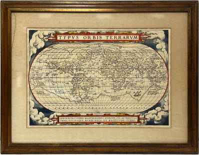
Sold2024Vintage Full Color World Map LithographVintage full colored world map, reading Typvs Orbis Terrarvm with blue and red colors and scrolled motifs with Greco Roman lion and Figural heads and sections in Latin Frame in a tan toned wooden framSee Sold Price
Sold2020Sanson Orbis Vetus World Map Paris 1657Nicolas Sanson (1600-1677), "Orbis Vetus, et Orbis Veteris Utraque Continens, Terrarumque Tractus Arcticus, et Antarcticus ex Platone, Thopompo, sive Aeliano, Manilio & c." Paris: P. Mariette, 1657. HSee Sold Price
Sold20191821 Chart of the World Map This is a mercator'sThis is a mercator's projection of North America by John Purdy, published Jan 1, 1821 by Richard Holmes Laurie, measures 40" wide by 26.5" tall.See Sold Price
Sold20241882 Black World Map -- The World on Mercator's ProjectionTitle: 1882 Black World Map -- The World on Mercator's Projection Cartographer: A&C Black Year / Place: 1892, Edinburgh Map Dimension (in.): 16.8 X 22 in. This is an excellent world map, with color coSee Sold Price
2 days LeftTrillium Antique Prints & Rare BooksDe Jode, Rare, pub. 1593 - Map of Kingdom of Napoli, Italy (Neapolitani Regni exacta ac diligensUS$130(3 bids)
2 days LeftTrillium Antique Prints & Rare BooksDe Jode, Rare, pub. 1593 - Map of the Holy Land (Descriptio Et Situs Terrae Sanctae Alio NomineUS$100(1 bid)
2 days LeftTrillium Antique Prints & Rare BooksDe Jode, Rare, pub. 1593 - Map of Hainut, Belgium (Hannoniae Comitatus Descriptio)US$100(1 bid)
Jun 07Freeman's | Hindman[MAP]. ORTELIUS, Abraham. Americae Sive Novi Orbis, Nova Descriptio. 1573.US$1,000(1 bid)
2 days LeftTrillium Antique Prints & Rare BooksBraun & Hogenberg, pub. 1575 - View of Chios, GreeceUS$120(2 bids)
2 days LeftTrillium Antique Prints & Rare BooksBraun & Hogenberg, pub. 1575 - Lower View of Rome, ItalyUS$100
2 days LeftTrillium Antique Prints & Rare BooksBraun & Hogenberg, pub. 1575 - Views of Copenhagen, DenmarkUS$100
2 days LeftTrillium Antique Prints & Rare BooksBraun & Hogenberg, pub. 1575 - View of Granata (Granada), SpainUS$100
2 days LeftTrillium Antique Prints & Rare BooksBraun & Hogenberg, pub. 1575 - View of Dordrecht, NetherlandsUS$100
2 days LeftTrillium Antique Prints & Rare BooksBraun & Hogenberg, pub. 1575 - View of Perugia, ItalyUS$100
6 hrs LeftPotter & Potter AuctionsAir France / Reseau Aerien Postal. 1948. Paris: Perceval. L...US$150
6 hrs LeftPotter & Potter AuctionsPan American Airways World System Map. 1956. Art by John Br...US$200
397 Lots AwayOriental Art AuctionsAL-IDRISI AND ROGER II, A MAP OF ASIA IN NUZHAT AL-MUSHTAQ, 17TH CENTURY€4,000
Jun 01Northgate Gallery, Inc.Vintage Baker Furniture George II Style Wing Back Arm Chairs, PairUS$200


![[World Map]. Rumold Mercator. Orbis terrae compe: [World Map]. Rumold Mercator. Orbis terrae compendiosa descriptio.&](https://p1.liveauctioneers.com/906/93415/47683584_1_x.jpg?height=310&quality=70&version=1473203012)
![[World Map]. Rumold Mercator. Orbis terrae compe First Image](https://p1.liveauctioneers.com/906/93415/47683584_1_x.jpg?height=300&quality=1&version=1473203012&width=300)
![[World Map]. Rumold Mercator. Orbis terrae compe First Image](https://p1.liveauctioneers.com/906/93415/47683584_1_x.jpg?height=300&quality=95&version=1473203012&width=300)

![Mercator World Map: *** START PRICE IS THE RESERVE *** [World] MERCATOR, Rumold (1545-1599). Orbis Terrae Compendiosa Descriptio Quam ex Magna Universali Mercatoris... Engraved Map with original hand color. Geneva, 1587.](https://p1.liveauctioneers.com/1968/163248/82424686_1_x.jpg?height=310&quality=70&version=1583340284)


![Africa.- Ortelius (Abraham) Africae Tabula Nova, engraved map, [c.1570-1612].: Africa.- Ortelius (Abraham) Africae Tabula Nova, detailed map of Africa based upon Gastaldi's 8 sheet wall map and Mercator's world map of 1569, decorated with a strapwork title cartouche, a sea battl](https://p1.liveauctioneers.com/5458/269991/141255679_1_x.jpg?height=310&quality=70&version=1669303305)


![[MAP]. ORTELIUS, Abraham. Americae Sive Novi Orbis, Nova Descriptio. 1573. (1 of 2)](https://p1.liveauctioneers.com/197/329395/177650534_1_x.jpg?height=282&quality=70&version=1715364962)
![[MAP]. ORTELIUS, Abraham. Aevi Veteris, Typus Geographicus. 1601. (1 of 3)](https://p1.liveauctioneers.com/197/329395/177650532_1_x.jpg?height=282&quality=70&version=1715364962)


