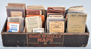
Sold2016VINTAGE RAND McNALLY MAP DISPLAY w/ MAPSVery early Rand McNally display Comes full of vintage maps. 19"x7" Very GoodSee Sold Price
2022Vintage Rand McNally 1967 edition of antique Plantation MapRand McNally 1967 edition of 1858 Plantation Map of the Mississippi River. 62"h x 40"wSee Sold Price
Sold2018Vintage WWII Colliers War Map of Europe, 1942Title/Content of Map: Colliers War Map of Europe Date Printed: 1942 Cartographer: RAND MCNALLY & COMPANY Publisher: P. F. COLLIER & SON CORPORATION 1942 NEW YORK Size: Folio – 19.00 H x 25.75 W InchSee Sold Price
Sold2021Rand McNally maps rack w/ nine paper mapsEsso & Standard oil Maps from different countries in different languages, 14" tall X 19" wideSee Sold Price
Sold2024Vintage 1920s Rand McNally Auto Trails MapMarked on upper corner Rand McNally Official Auto Trails Map of The United States, copyright by Rand McNally & Company. Depicts the whole of the United States with Trails and marked roads in red alongSee Sold Price
Sold2020Antique Wall MapAntique Wall Map 1890s Rand McNally Master Map of USA Railroad and Land 9' X 10' 114" W 9"D Two MapsSee Sold Price
Sold2023FRAMED MAP OF CHICAGO1895 Rand-McNally Map of Downtown Chicago, from Chicago Ave. to West 22nd St. In a walnut-stained oak frame, matted and glazed, OS: 19" x 16 1/2", SS: 13" x 11". Light bend.See Sold Price
Sold2018Group of Four Vintage American Pocket Maps[Maps] Group of Four Vintage American Pocket Maps. Chicago: Rand McNally, 1913 – 14. Including California, Alabama, Washington and Oregon. Brown paper wraps. Pictorial ads, fold out color maps.See Sold Price
Sold2015Map of California, 1895Original map published from Indexed Atlas of the World by Rand McNally, 1895. Map features insets of San Francisco area & San Diego county. Unframed. Dimensions: 32" L x 25.5" WSee Sold Price
Sold2021Vintage Atlas School Map CabinetVintage Atlas School map cabinet, to include vintage world maps in wooden display case 19"h x 53.5"w x 4"d Provenance: The Estate of Barbara "Babs" Baugh (San Antonio, Texas) WeSee Sold Price
Sold2022Vintage Travel Destination Maps & EphemeraThere is a 1949 Rand McNally road atlas, 40+ vintage maps including locations such as New York, Pittsburgh, Boston, Ohio, Pennsylvania, New Jersey, advertising ephemera for various companies includingSee Sold Price
Sold2019Rand-Mcnally Dollar Atlas of the WorldTitle/Content of Map: Rand-Mcnally Dollar Atlas of the World Date: c1907 Cartographer: RAND, MCNALLY & COMPANY Publisher: RAND, MCNALLY & COMPANY Size: 7.3"H x 6.3"W Historical-Political-Commercial coSee Sold Price
Sold2021ca. 1929 RAILROAD UNITED STATES MAP SHOWING NEW YORKVintage Railroad Map, "MAP of THE UNITED STATES SHOWING NEW YORK CENTRAL LINES". Map by Rand McNally and Co. Includes printed information on the reverse. Tiny text along bottom partly reads; "NY 4-29"See Sold Price
Sold2022Rand, McNally and Co.'s Georgia Map 1889Antique map of Georgia #193. Some railroad stops in red, some in grey and others in green. Ornamental yellow border. Sight size - 20.5"H x 13.75"W. Matt board size - 25.5"H x 18.75"W. Weight - 14.2 ozSee Sold Price
Sold2024Vintage Street Map of Pittsburgh, Pennsylvania - Rand McNallyThis is an original, not reproduction, vintage Pittsburgh city map which was carefully removed from a Rand McNally atlas published in 1942. Size: 34 cm x 26 cmSee Sold Price
Sold2023VINTAGE TRANSPORTATION / TRAVEL EPHEMERA, UNCOUNTED LOTVINTAGE TRANSPORTATION / TRAVEL EPHEMERA, UNCOUNTED LOT,with time table and pocket map examples, including Illinois Terminal, Rand McNally, and a 1912 Ohio Railway Map.20th century. Provenance: From tSee Sold Price
Sold2023Hand Colored Map of Alabama by Rand McNally, 1881Hand colored map of Alabama by Rand McNally, 1881. Frame size: 22" H x 18 1/2" x 1" D. Sight size: 13 5/8" H x 10 1/4" W.See Sold Price
Sold2023Vintage Gold Plated Chain /w Charms - Map of Israel, Menorah, etc.Vintage Gold Plated Chain /w Charms - Map of Israel, Menorah, etc.. Very good vintage condition. Displays amazingly.See Sold Price
Sold2022Red Mining District Original Map; 1891 [152840]Real, original Map of the Red Mountain Mining District, Ouray County, Colorado. Scale of 1000 ft. to 1 inch. W.A. Sherman M.E. Ouray, Colo. 1891. Printed by Rand McNally & Co. Engravers, Chicago. HasSee Sold Price
Sold2019Large Colored Map of Louisiana, 1907, from the RandLarge Colored Map of Louisiana, 1907, from the Rand McNally Indexed Atlas of the World, double folio, showing railroads, presented in a mahogany frame with a gilt liner, H.- 19 1/4 in., W.- 25 3/4 in.See Sold Price
Sold2022Scarce map of U. S. from McNally Indexed atlas, 1891Vintage and large single page map of the United States from the scarce Rand McNally 1897 Indexed Atlas of the World, likely the finest atlas the Rand McNally company ever produced. Oklahoma still showSee Sold Price
Sold2015Copper Engraved Map of Pere Marquette Railroad andCopper Engraved Map of "Pere Marquette Railroad and Connections," c. 1901, by Rand, McNally, & Co. (Chicago, IL), overall (framed): 17.5"h x 16.5"w. Provenance: From the Pittsburgh, PA estate of RichaSee Sold Price
Sold20181886 Rand McNally World Map -- Map of the WorldTitle/Content of Map: 1886 Rand McNally World Map -- Map of the World Date: 1886, Chicago Cartographer: Rand McNally Size: 12.8 x 19.5 in. Very nice world map, offering details on topography and settlSee Sold Price
20 hrs LeftJasper521914 Rand McNally Map of Austria-Hungary [verso] German Empire -- Austria-Hungary [verso] GermanUS$30
20 hrs LeftJasper521898 Rand McNally Map of Texas [verso] Indian Territory and Oklahoma -- Texas [verso] Oklahoma andUS$70
2 days LeftJasper52CZECHOSLOVAKIA. w/ Carpathian Ruthenia. Prague/Praha. Bohemia Moravia 1920 mapUS$25
May 25Cain Modern AuctionsDouble Sided U.S. Map by Rand McNally, Illustrated & Equal Area ProjectionUS$75
2 days LeftPotter & Potter AuctionsUnited Airlines DC-8 Display Mock-Up. Circa 1950s. Tempera ...US$125


![Group of Four Vintage American Pocket Maps: [Maps] Group of Four Vintage American Pocket Maps. Chicago: Rand McNally, 1913 – 14. Including California, Alabama, Washington and Oregon. Brown paper wraps. Pictorial ads, fold out color maps.](https://p1.liveauctioneers.com/928/124137/63148815_1_x.jpg?height=310&quality=70&version=1530051387)


![Red Mining District Original Map; 1891 [152840]: Real, original Map of the Red Mountain Mining District, Ouray County, Colorado. Scale of 1000 ft. to 1 inch. W.A. Sherman M.E. Ouray, Colo. 1891. Printed by Rand McNally & Co. Engravers, Chicago. Has](https://p1.liveauctioneers.com/2699/258191/134290995_1_x.jpg?height=310&quality=70&version=1660351799)


![1914 Rand McNally Map of Austria-Hungary [verso] German Empire -- Austria-Hungary [verso] German (1 of 2)](https://p1.liveauctioneers.com/5584/328338/176911532_1_x.jpg?height=282&quality=70&version=1715113718)
![1888 Rand McNally Map of Louisiana -- [Louisiana] (1 of 1)](https://p1.liveauctioneers.com/5584/328338/176911517_1_x.jpg?height=282&quality=70&version=1715113718)
![1898 Rand McNally Map of Texas [verso] Indian Territory and Oklahoma -- Texas [verso] Oklahoma and (1 of 2)](https://p1.liveauctioneers.com/5584/328338/176911581_1_x.jpg?height=282&quality=70&version=1715113718)


