Sold2022LONDON UNDERGROUND tube map diagram plan. First STINGEMORE edition 1925TITLE/CONTENT OF MAP: Underground Railways of London [694 11.5.25] This is the first edition of an Underground geographic map designed by F H Stingemore. It is one of the first designs not to show anySee Sold Price
Sold2018LONDON. Vintage Underground / Tube map 1933 old vintageTITLE/CONTENT OF MAP: 'Map of the Underground Railways of London' DATE: 1933 IMAGE SIZE: Approx 18.5 x 30.5cm, 7.25 x 12 inches (Medium) TYPE: Colour vintage street atlas map CONDITION: Good; suitableSee Sold Price
Sold2023LONDON UNDERGROUND LINE CAR TUBE MAP DIAGRAMSLONDON UNDERGROUND LINE CAR TUBE MAP DIAGRAMS Three London Underground Line Car diagrams, including Northern Line, Central Line, and District Line (unframed). Framed pieces are adhered to foam boardSee Sold Price
Sold2023THE SHETLAND ISLANDS antique map by GW BACON Scotland 1885 oldTITLE/CONTENT OF MAP: 'The Shetland Islands' DATE PRINTED: 1885 IMAGE SIZE: Approx 33.0 x 24.0cm, 13 x 9.5 inches (Large); Please note that this is a folding map. TYPE: Colour Antique Lithograph Map CSee Sold Price
Sold2017Map LotLot (2) maps including Ireland (G.W. Bacon & Co. sight 8 1/2" x 12"), and "BAVARIA-HESSE/US ZONE/WURTEMBERG BADEN" (sight 23" x 20").See Sold Price
Sold2022London.- Bacon (George W.) Bacon's New Map of LondonLondon.- Bacon (George W.) Bacon's New Map of London divided into half mile squares and circles, lithograph with some hand-colouring, sheet 680 x 990 mm (26 3/4 x 39 in), mounted on linen, folding intSee Sold Price
Sold2023Bacons New Map of London illustrated guide Overall good condition.Bacons New Map of London illustrated guide Overall good condition.See Sold Price
Sold2023S AMERICA NW. Colombia Ecuador Peru Bolivia Venezuela Amazonos. Lima 1893 mapTitle: S AMERICA NW. Colombia Ecuador Peru Bolivia Venezuela Amazonos. Lima 1893 map Description: South America N.W; Inset map of Lima' by GW Bacon (1893). Antique colour map, 26.0 x 17.5cm, 10.25 x 7See Sold Price
Sold2020The Wonderground Map of London Town 1915 MacDonalLeslie MacDonald Gill (1884-1947), "The Wonderground Map of London Town," London, 1915. This highly detailed and eye-catching map was commissioned by the London Underground to entertain passengers waiSee Sold Price
Sold2021Bacon's Map of Manchester Corrected to the PresentPublication Date: c1910 Title: Bacon's Map of Manchester Corrected to the Present Time... Cartographer: Bacon, G.W. & Co.G.W. Bacon & Co. Height: 14.2 Width: 21.75 Highly detailed city plan folding inSee Sold Price
Sold2022London Tube Railways. 11 proposed new/extended Underground lines HMSO 1901 mapTITLE/CONTENT OF MAP: 'London tube railways 1901' This fascinating map, drafted by the Civil Engineer Sir Alexander Binnie in his capacity as Chief Engineer of London County Council, shows the developSee Sold Price
Sold2023BAYSWATER MAIDA VALE Paddington Bayswater Westbourne Park St Johns Wood 1900 mapTitle: BAYSWATER MAIDA VALE Paddington Bayswater Westbourne Park St Johns Wood 1900 map Description: Sheet 43 from Bacon's 1900 London street atlas covering part of West London including Paddington, BSee Sold Price
Sold2022Slatter & Rose's Motoring and Cycling Road Map. OxfordTitle: Slatter & Rose's Motoring and Cycling Road Map. Oxford District. Cartographer: Bartholomew, John & Co. Publisher: G.W. Bacon & Co., LTD. Height: 24 Width: 34 Extremely early road map intended fSee Sold Price
Sold2023WANSTEAD ILFORD BARKING Forest Gate Seven Kings Chadwell Heath. BACON 1906 mapTITLE OF MAP (NOT PRINTED ON THE PAGE):'Sheet 8 from Bacon's 1906 London street atlas covering part of North East London inc. Wanstead, Ilford, Barking, Forest Gate, Seven Kings, Chadwell Heath.' DATESee Sold Price
Sold20211892 Egypt MapAuthor: Bacon Title: 1892 Egypt Map Medium: Ink on Paper Dimenions: 13.5"X21" Description: Map of Egypt dated 1892. Part of Bacon's Commercial and Library Atlas of the World. Published by G.W. Bacon iSee Sold Price
Sold20211892 Map of Euro-AsiaTitle: 1892 Map of Euro-Asia Medium: Ink on Paper Dimensions: 19"X13.5" Description: Map of Europe and Asia dated 1892. Part of Bacon's Commercial and Library Atlas of the World. Published by G.W. BacSee Sold Price
Sold2023SOUTH AMERICA NE. Brazil. Inset Rio de Janeiro; Trinidad. BACON 1893 old mapTitle: SOUTH AMERICA NE. Brazil. Inset Rio de Janeiro; Trinidad. BACON 1893 old map Description: South America; Inset maps of Environs of Rio de Janeiro; Trinidad' by GW Bacon (1893). Antique colour mSee Sold Price
Sold2023SOUTH AMERICA. Buenos Aires Rio de Janeiro. Bolivia < Chaco War. BACON 1903 mapTitle: SOUTH AMERICA. Buenos Aires Rio de Janeiro. Bolivia < Chaco War. BACON 1903 map Description: South America; Inset maps of Environs of Buenos Ayres; Environs of Rio de Janeiro' by GW Bacon (1903See Sold Price
Sold2019Road-Map of England And WalesTitle: Road-Map of England And Wales Publication Date: 1835-03-25 Cartographer: BACON, G. W. & CO. Publisher: G.W. BACON & CO. Dimension: 33Height - 26.5Width Retailed by Forster Groom & Co. Ltd. DissSee Sold Price
Sold2018CENTRAL LONDON TRANSPORT. Railways & underground tubeCENTRAL LONDON TRANSPORT. Railways & underground tube DATE: 1906 IMAGE SIZE: Approx 22.0 x 27.5cm, 8.5 x 10.75 inches (Medium); Please note that this is a folding map. TYPE: Antique colour travel mapSee Sold Price
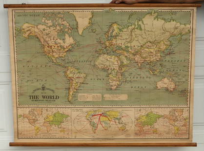
Sold2015Bacon's Excelsior Map of The WorldOn Mercator's Projection, printed in London by G. W. Bacon & Co., Ltd., circa 1880. Chromolithograph laid on canvas with both original wood hangers. 39 1/2" x 30".See Sold Price
Sold2018Canada C1880's Lot of 7 Antique Maps by Letts, BaconSet of 4 on 4 sheets, plus 1 general map. Lithograph Maps Published 1880's, London for "Letts's Popular Atlas" Together with 2 others by Bacon. Paper Size: up to 17 x 14 inch (43 x 36cm) Good conditioSee Sold Price
Sold2022SOL LEWITT (1928-2007) R706 Map of London with the area between the underground stations at Marb...SOL LEWITT (1928-2007) R706 Map of London with the area between the underground stations at Marble Arch, St. James Park, Leicester Square, Waterloo Station, Pimlico, Sloane Sq., Knightsbridge, BayswatSee Sold Price
Sold2021Eight London Underground and Other Travel PostersEight London Underground and Other Travel Posters 20th Century including two Espana posters, Biarritz, and Mont-Revard, a Shop By Underground poster, From 430 to 1, By Tram to Hampton Court, and See TSee Sold Price
19 hrs LeftTremont Auctions18th century map of New Jersey. "A New and Accurate Map of New Jersey". W. Long, London. Map size 13US$100
1818 AuctioneersA Collection of Royal Mint Brilliant Uncircultaed Coins, Platinum Jubilee £5, Tudor Beasts £55(3 bids)
5 days LeftSwann Auction GalleriesCHARLES BURTON (1882-?). WIMBLEDON FROM JUNE 23RD. 1930. 9½x13 inches, 24¼x33 cm. TheUS$1,100
5 days LeftSwann Auction GalleriesFRANK NEWBOULD (1887-1950). SWIFT / WORLD'S BEST CYCLES. Circa 1930s. 59¼x39 inches, 150½US$3,000
4 days LeftJasper52WEST INDIES. Cuba Jamaica Lesser Antilles. Inset Havana Kingston. BACON 1893 mapUS$20
3 days LeftJasper521720 Strype Ward Map of London's Cheape Ward Between St. Paul's and Bank of England -- Cheape WardUS$70


![LONDON UNDERGROUND tube map diagram plan. First STINGEMORE edition 1925: TITLE/CONTENT OF MAP: Underground Railways of London [694 11.5.25] This is the first edition of an Underground geographic map designed by F H Stingemore. It is one of the first designs not to show any](https://p1.liveauctioneers.com/5584/263211/137236971_1_x.jpg?height=310&quality=70&version=1664917902)