Sold2017Texas nach den Besten Quellen Map, 19th CMap: Texas nach den Besten Quellen Cartographer: Bibliographischen Instituts. / Radefeld Place & Date: Hildburghausen / 1849/1857 Size: 13 7/8" x 11 1/2" Condition: original outline color The scarce sSee Sold Price
Sold2020Radefeld 1846 Map of Texas, FramedCarl Christian Franz Radefeld. "Texas Nach den besten Quellen," hand colored engraving, 13 x 15 1/4 in.Property from the collection of Robert and Nancy Hall, Baltimore, MD. Proceeds benefit the RobertSee Sold Price
Sold2022Antique 19th C. Ohio Map, J. Meyer (German) 1845An original steel engraved atlas map "Neuste Karte von Ohio mit seinen Canaelen, Strassen & Entfernungen der Hauptpunkte. Nach den bessten Quellen verbessert. 1845" Joseph Meyer (German, 1See Sold Price
Sold2020Meyer's U.S. with Texas an independent country 1845Heading: (Texas) Author: Meyer, Joseph Title: Nord-Americanische Freistaaten 1845 Nach den besten Quellen entworf. u. gezeich. v. Hauptm. C. Radefeld Place Published: Hildburghausen Publisher:BibliogrSee Sold Price
Sold2019Gräße, J.G.Theodor Handbuch der AltenNumismatik Gräße J.G.Theodor Handbuch der Alten Numismatik von den ältesten Zeiten bis auf Constantin d. Gr. Nach den besten Quellen bearbeitet und mit vielen Abbildungen der schönSee Sold Price
Sold2022Der Deutsch-Französische Krieg 1870-71 (HARDCOVER with Great Picture Plates)Der Deutsch-Französische Krieg 1870-71 in Wort und Bild. Nach den besten Quellen bearbeitet (HARDCOVER with Great Picture Plates) Average Condition.See Sold Price
Sold2022Early Nineteenth Century Map of Texas.Early 19th century hand colored map of Texas published by C.S. Williams, NE Corner of Market and 7th St., Philadelphia, 1845. Map engraved by J.H. Young exhibits previous folds and has been laid down.See Sold Price
Sold2020Grp: 6 Maps of SpainGroup of six maps of France and Spain. Includes Friedrich Wilhelm Streit (1772-1839) map of France "Charte von Frankreich nach den besten Hulfsmitteln," Nuremberg, 1815; Guillaume Delisle (1675-1726)See Sold Price
Sold20181845 Meyer Map of Tennessee -- Neueste Karte vonReserve Reduced! Title/Content of Map: 1845 Meyer Map of Tennessee -- Neueste Karte von Tennessee nach den Bessten Quellen Verbessert 1849 Date: 1845, Hildburghausen Cartographer: J Meyer Size: 11.6 XSee Sold Price
Sold2019MAP - Ohio. MeyerOhio. Joseph Meyer, Neueste Karte von Ohio mit Seinen Canaelen, Strassen & Entfernungen der Hauptpunkte. Nach den Bessten Quellen Verbessert, 1845 (dated). Hand Color. Fine early map showing counties,See Sold Price
Sold20211849 Meyer Map of Tennessee -- Neueste Karte vonTitle: 1849 Meyer Map of Tennessee -- Neueste Karte von Tennessee nach den Bessten Quellen Verbessert 1849 Cartographer: J Meyer Year / Place: 1849, Leipzig Map Dimension (in.): 12 X 15 in. Elegant anSee Sold Price
Sold2023Highly collectible 1860 RR map of Texas, S. A. Mitchell, Jr.One of the most attractive atlas maps of Texas to appear in the mid-19th century. This authentic antique map (160 years old) was published when the Civil War was at its height. It shows the region froSee Sold Price
Sold2024Bencharong-Schale fuer den Export nach Thailand, China, Qing-Dynastie, 18./19. Jh.Bencharong bowl for export to Thailand . China, Qing dynasty, 18th/19th century Bellied form over a round base ring; the outer wall with the temple deity Thepphanom in a worship pose and the mythologiSee Sold Price
Sold2022Exceptional 1864 RR map of Texas, S. A. Mitchell, Jr.One of the most attractive atlas maps of Texas to appear in the mid-19th century. This nearly 160-year-old map--published during the height of the Civil War--shows the region from western New Mexico tSee Sold Price
Sold2018Early 19th Century Map of LouisianaEarly 19th Century Map of Louisiana(Baltimore: F. Lucas, 1817), engraving with outline color, depicts adjacent areas in Mississippi, Alabama, Florida, Texas and Arkansas (being labeled "Missouri"). PrSee Sold Price
Sold2017Mitchell: Hand Colored Map of Texas, 1854Map: Hand Colored Map of Texas Maker: Samuel Augustus Mitchell Date: 1854 Size: Approx. 5.5x7 inches Hand colored. From the 1854 Mitchell's School Atlas by Samuel Augustus Mitchell in the 19th centurySee Sold Price
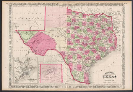
Sold2023Excellent example of Johnson’s Texas, 1866Authentic and impressive vintage map of Texas. One of the more collectible maps to be produced in the mid-19th century. A highly desirable map that details the state in full. Shows the elevated TableSee Sold Price
Sold20211864 American History INDIANS Mexico TEXAS Revolution1864 American History INDIANS Mexico TEXAS Revolutionary War US Map Willson Marcus Willson’s “American History” is a mid-19th-century compendium of the history of the United States from its earlSee Sold Price
Sold2021Early Hand-colored Maps17th- 19th c hand-colored maps ( pcs), including Ortelius "Transsylvaniae", Pieter van der Keere "Lancastria", Rapkin "Egypt and Arabia Petraea" Grassl "Californien, Texas", Rapkin "China & Burma", ovSee Sold Price
Sold20211843 Weekly Globe RARE American Magazine MAP Washington1843 Weekly Globe RARE American Magazine MAP Washington DC Politics LAW Texas ‘The Weekly Globe’ was a 19th-century American periodical out of Washington D.C. This regularly published magazine preSee Sold Price
Sold2023John Bachmann, "Bird's Eye View: Texas and Part of Mexico"John Bachmann (Amer., 19th C.), "Bird's Eye View: Texas and Part of Mexico", from the series "Panorama of the Seat of War", (6) chromolithographic maps of Confederate states in panSee Sold Price
Sold2022Group of 14 Maps of Great Britain, Framed Celestial Map17th-19th century, engravings on laid or wove paper, all with hand colored highlights, comprising: John Speed, Darby Shire, London, circa 1630-1640, engraved by Peter Van Den Keere; John Owen & EmanueSee Sold Price
Sold2020German map of California & Texas 1852Heading: (Texas) Author: Meyer, Joseph Title: Vereinigte Staaten von Nord-America: Californien, Texas und die Territorien New Mexico u. Utah Nach den neuesten Hülfsmitte In gezeich. von J. Grässl. 1See Sold Price
Sold2018[Texas] 19th c. Reward PosterBroadside. 19th century, Wellington, Texas. 8.75" x 6". Toned, light staining, two very faint creases as once folded, one small hole, Good. ***** "$25.00 Reward / For man and mules. Strayed or stolenSee Sold Price
Jun 23Schilb Antiquarian Rare Books1848 Emory Military Reconnaissance 1ed California MAP Indians Texas New MexicoUS$2(2 bids)
5 days LeftGold Coast Auctioneers17th-19th c. French Wall Art Collection Map City Sea Scapes Scenes etc.US$50
Jun 07Five Star AuctionsAn Exquisite Monumental 19th C. Italian Ignace Spiridon Framed Oil On Canvas PaintingUS$50,000
13 hrs LeftJasper521720 antique MAP of LOWER SAXONY GERMANY 18th CENT. Circulus Saxoniae inferiorisUS$75
Jun 04Heritage Auctions61092: A Pair of Gilt Metal Cloisonné Enamel Two-HandlUS$500(1 bid)


![[Texas] 19th c. Reward Poster: Broadside. 19th century, Wellington, Texas. 8.75" x 6". Toned, light staining, two very faint creases as once folded, one small hole, Good. ***** "$25.00 Reward / For man and mules. Strayed or stolen](https://p1.liveauctioneers.com/3532/125343/63770768_1_x.jpg?height=310&quality=70&version=1532476745)


