Sold20231859. Minnesota & Dakota territory. By Colton>Title: 1859. Minnesota & Dakota territory. By Colton Date/Period: 1859 Materials: Steel engraved Size: 17 1/2 x 14 1/2” Minnesota and Dakota territory. Important map in the settlement of the regionSee Sold Price
Sold20191834 Map of the route passed over by an expedition intoThis highly detailed map depicts the territory of the region between the Red River and Lake Superior within present day Minnesota. The map is centered on the course of the Missisippi River above LakeSee Sold Price
Sold2024Cincinnati Hamilton and Dayton RR Map -USGC 1889This is an amazing color map with 24 foldable panels, paper on linen, as produced by the United States Geological Committee in 1899. Highlighted on this map are all railroads in the region, includingSee Sold Price
Sold2023Rare Mt. Tam Railway schedule & map 1899Heading: (California - Marin County) Author: Title: Mill Valley and Mt. Tamalpais Scenic Railway Place Published: [Mill Valley, Calif.] Publisher:[Mill Valley & Mt. Tamalpais Scenic Railway Co.]See Sold Price
Sold20221930's Road Maps Minnesota, Oregon & Ontariorated 7 to 8, 9"x4", light wear.See Sold Price
Sold20181899 Stanford Map of South Africa During the Boer WarTitle/Content of Map: 1899 Stanford Map of South Africa During the Boer War -- The Crisis in South Africa. Stanford's New Map of the Orange Free State, the Southern Part of the South African Republic,See Sold Price
Sold2019Minnesota, Dakota’sTitle/Content of Map: Minnesota, Dakota’s Date: 1863 Cartographer: By Johnson & Ward. From, Johnson’s New Illustrated Family Atlas Size: 18x14” Provenance: New York Additional Info: Hand coloredSee Sold Price
Sold2018Colton: Antique Map of Minnesota & Dakota, 1859Title/Content of Map: Minnesota & Dakota by Colton Date Printed: 1859 Cartographer: H.J. Colton Material/Medium: Paper Size: 17 1/4" X 15" Hand colored,engraved. Published in New York in 'Colton's GenSee Sold Price
Sold20181899 US Dept. of Interior Survey Map of Louisiana --Reserve Reduced! Title/Content of Map: 1899 US Dept. of Interior Survey Map of Louisiana -- Louisiana Date: 1899, Baltimore Cartographer: US Dept. of Interior / Bureau of American Ethnology Size: 9.3See Sold Price
Sold2017Colton: Antique Map of Minnesota, 1871Title/Content of Map: Minnesota by Colton Date Printed: 1871 Cartographer: G. W. Colton Material/Medium: Paper Size: 15" x 17" Hand colored lithograph. From 'Colton's American Atlas.' Published in NewSee Sold Price
Sold2017Mitchell: Antique Map of Minnesota, 1869Title/Content of Map: Minnesota by Mitchell Date Printed: 1869 Cartographer: Augustus S. Mitchell Material/Medium: Paper Size: 12" x 15" Hand colored engraved Map. From 'Mitchell's New General Atlas.'See Sold Price
Sold2017Archeological Exploration in Caves of Point of PinesArcheological Exploration in Caves of the Point of Pines Region Arizona. Gifford, James C. Anthropological Papers of the University of Arizona, Number 36. Tucson, Arizona: The University of Arizona PrSee Sold Price
Sold2018Antique John Smith Atlantic Region Map Virginia OrigState 10: Page 41, numbers changed to 1690 and 1691. A true piece of American history, not a reproduction!Fine example of John Smith's map of the newly formed Virginia colony, one of the true milestonSee Sold Price
Sold2017Cary: US Western Territory/Great Lakes Region Map, 1805Map: A New Map of Part of the United States of North America, exhibiting the Western Territory, Kentucky, Pennsylvania, Maryland, Virginia &c., also the lakes Superior, Michigan, Huron, Ontario & ErieSee Sold Price
Sold2022Mexico, shows a independent Republic of Texas. Important S.W region map. 1846 by A and C BlackMexico with a independent Republic of Texas, shown at its largest territorial expanse. Although Texas would join the Union in 1845, this map was published in 1846 but was not updated in time making itSee Sold Price
Sold2023Map of Minnesota Territory by J.H. Young, 1854Map of Minnesota Territory by J.H. Young, Published by Cowperthwait, Desilver & Butler, Philadelphia, 1854. Scale 1:2,400,000 Image measures 15 1/2" x 12 1/2". Frame measures 22&quSee Sold Price
Sold2016MAP OF MINNESOTA TERRITORY BY J.H. YOUNG 1854Hand tinted lithograph map by J.H. Young, Cowperthwait, Desilver & Butler, 1854. Measures 14 x 17.2 inches overall. Depicts the Minnesota territory, lakes, rivers, forts, and native American tribal reSee Sold Price
Sold2018Early pocket map of MinnesotaHeading: Author: Colton, J.H. Title: Minnesota Place Published: New York Publisher:J.H. Colton & Co Date Published: 1855 Description: Folding color map, 12 x 15 inches. FolSee Sold Price
Sold2017Young: Map of Minnesota Territory, 1850Map: Map of Minnesota Territory Maker: J. H. Young Publisher: Cowperthwait, DeSilver & Butler Publishing Date: 1850 (1854) "Important early map of Minnesota Territory, including all of Dakota, from thSee Sold Price
Sold20201855 Colton Map of Minnesota and the Dakotas --Title: 1855 Colton Map of Minnesota and the Dakotas -- Minnesota Cartographer: J Colton Year/Place: 1855, New York Size: 11.8 X 15.7 in. Description: This is an excellent map of Minnesota and the emerSee Sold Price
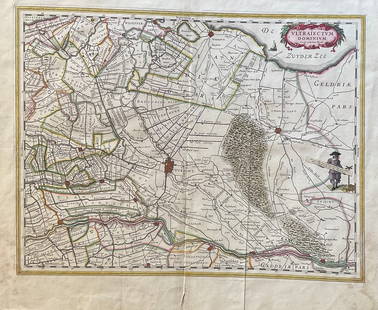
Sold2023The Netherlands Map. The region Around the city of Utrecht. 1660?s by W. BlaeuTitle: The Netherlands Map. The region Around the city of Utrecht. 1660?s by W. Blaeu Date/Period: 1660?s Materials: Hand colored copper plate engraved Size: 22 x 19 1/2'' Netherlands regional map cenSee Sold Price
Sold20191855 Colton Map of Minnesota and the Dakotas --Reserve Reduced! Title/Content of Map: 1855 Colton Map of Minnesota and the Dakotas -- Minnesota Date: 1855, New York Cartographer: J Colton Size: 11.8 X 15.7 in. This is an excellent map of MinnesotaSee Sold Price
Sold20201858 Map of Minnesota and DakotaAuthor: Johnson Title: 1858 Map of Minnesota and Dakota Medium: Ink on Paper Dimensions: 18"X14.5" Map of Minnesota and Dakota dated 1858. Engraved by A.J. Johnson. Published by Johnson and Ward in NeSee Sold Price
Sold2023Early Hand Colored Map French Region, approx. 26" X 33"Early Hand Colored Map French Region, approx. 26" X 33"See Sold Price
5 days LeftJasper521853 Williamson Map of California's Tejon Pass Region -- Map and Profile of the Cañada de lasUS$55
6 days LeftJasper52COLONIAL EAST AFRICA. German/British/Portuguese East Africa. Tanzania 1899 mapUS$45
5 days LeftJasper521852 Norwood Geological Map of Wisconsin and Minnesota -- Geological Map of Parts of Minnesota andUS$55
6 days LeftJasper52COLONIAL AFRICA. British East/Central/South Africa. Bechuanaland 1899 old mapUS$80
Jun 12Dan Morphy AuctionsPHELPS’S TRAVELERS GUIDE THROUGH THE UNITED STATES; CONTAINING UPWARDS OF SEVEN HUNDREDUS$1,000
5 days LeftJasper521852 Owen Geological Maps of the Pigeon River Minnesota -- (1) Geological Map Coast View and SectionUS$45
Jun 07Freeman's | HindmanHOMANN, Johann Baptist. Amplissimae Regionis Mississipi Seu Provinciae Ludovicianae. Nuremburg, [caUS$400(1 bid)
Jun 07Freeman's | Hindman[MAP]. ORTELIUS, Abraham. Peregrinationis Divi Pauli Typus Corographicus. 1592.US$150(1 bid)
4 days LeftMynt AuctionsEller Marshall Page Larsen Signed 16x20 Photo Framed Purple People Eater BASUS$10


![Rare Mt. Tam Railway schedule & map 1899: Heading: (California - Marin County) Author: Title: Mill Valley and Mt. Tamalpais Scenic Railway Place Published: [Mill Valley, Calif.] Publisher:[Mill Valley & Mt. Tamalpais Scenic Railway Co.]](https://p1.liveauctioneers.com/642/280725/147901344_1_x.jpg?height=310&quality=70&version=1678135933)


![[MAP]. ORTELIUS, Abraham. Peregrinationis Divi Pauli Typus Corographicus. 1592. (1 of 2)](https://p1.liveauctioneers.com/197/329395/177650535_1_x.jpg?height=282&quality=70&version=1715364962)


![Early French Map of Great Lakes [179300] (1 of 1)](https://p1.liveauctioneers.com/2699/331495/178785744_1_x.jpg?height=282&quality=70&version=1717094933)