Sold2017Map of MunichMUNICH MÜNCHEN MUNCHEN. Antique town city map plan & panorama. SDUK, 1847 Size: Approx 32.5 x 39.0cm, 12.75 x 15.5 inches (Large) Please note that this lot has a confidential reserve. When you leaveSee Sold Price
Sold2023APRIL 24, 1944 MUNICH BOMBING MAP AND BOMB RELEASE BUTTONBritish War Office 1:500,000 scale air map of Munich and the surrounding area, 28 x 24 in., originally compiled and drafted at the War Office in 1940, this second edition dated 1942. This perticular mSee Sold Price
Sold20231938 Map of the Munich to Salzburg Autobahn -- Reichs Autobahn Munchen SalzburgTitle: 1938 Map of the Munich to Salzburg Autobahn -- Reichs Autobahn Munchen Salzburg Cartographer: Year / Place: 1938-9 Map Dimension (in.): 8.3 X23.1 in.folded out brouchure This is a superb 8-pageSee Sold Price
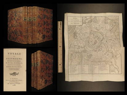
Sold20221788 Voyages Germany MAP Johann Riesbeck Letters Munich Vienna Austria 3v SET1788 Voyages Germany MAP Johann Riesbeck Letters Munich Vienna Austria 3v SET Johann Kaspar Riesbeck was a 18th-century German travel writer best-known for his book Letters from a French traveler in GSee Sold Price
Sold2022Antique Map - Map of Europe - Map of Germany - Berlin - Hamburg - MunichAntique map of Germany by Becker, published in London, c 1860. This antique map was engraved by the omnigraph method by Francis Paul Becker & Company, Patentees circa 1842, with contemporary hand coloSee Sold Price
Sold2022Colored Engraving AMERICA AUSTRALIS DEI PARAE Sacred Fines Aedes erexit in quib[us] magnos ab IllaColored Engraving AMERICA AUSTRALIS DEI PARAE Sacred Fines Aedes erexit in quib[us] magnos ab Illa favors accipit. Monachii/(Munich), Joannis Caspari Bencard, (1702) Map of America, from Isla (sic) CaSee Sold Price
Sold2017Scherer: 3 Catholic-themed Antique Maps, 1703Map: America Borealis Cartographer: H. Scherer Place & Date: Munich / 1703 Size: 7" x 9 1/4" Condition: b&w; light overall age toning Three maps on a single sheet from Scherer's Geographia ArtificialiSee Sold Price
Sold2020LOT of 2 MUNICH GERMANY ca. 1900 FOLDING ANTIQUE MAP &LOT of 2 MUNICH GERMANY ca. 1900 FOLDING ANTIQUE MAP & GUIDE BOOK by C. KAISER LOT of 2 MUNICH GERMANY ca. 1900 FOLDING ANTIQUE MAP & GUIDE BOOK by C. KAISER Description Lot of 2 Circa 1900 Antique MaSee Sold Price
Sold2020HEINRICH SCHERER "Map of France"GALLIA Reginae Coelitum obsequiosa & huic Illa multis in locis gratiosa. Monachii/(Munich), Joannis Caspari Bencard, (1702) Rare map of France by Jesuit H. Scherer for his Atlas Novus exhibens Orbem TSee Sold Price
Sold20171703 Scherer - World Map [California as an Island]Title: World Map [without title] "Map maker: Heinrich Scherer, Atlas Marianus" "Place and Year: Munich, 1703" "Dimensions: 23.6 x 35.5 cm (9.3 x 14 in)" "Technique: Copperplate engraving" "Coloring: USee Sold Price
Sold20181703 Scherer map of the Pacific with California andTitle: Tantum Distamus Ap Invicem Map maker: Heinrich Scherer; Atlas Novus Place and Year: Munich, 1703 Dimensions: 23 x 34 cm (9.1 x 13.4 in) Technique: Copperplate engraving Coloring: Uncolored CondSee Sold Price
Sold20181780 Moreau View of Nymphenburg Palace in Munich -- LeTitle/Content of Map: 1780 Moreau View of Nymphenburg Palace in Munich -- Le Pallais Electorale de Nymphenbourg Date: 1780 c. Augsburg Cartographer: J Moreau Size: 11.8 x 14.3 in. A scarce "vue d'optiSee Sold Price
Sold2019Two 1850s Munich Views: Marienplatz & NymphenburgMap Title: 1. Schrannenplatz in München 2. Nymphenburg. Cartogapher: 1. Lange/Hoffmeister 2. Poppel/G. Franz Place / Date: Munich / 1850sSize: 1. 6 1/4" x 4 1/4" 2. 6" x 3 3/4" Two delightful views oSee Sold Price
Sold2023Book Collection, Early Maps Of The Americas (10pc)(1) "America: Early Maps of the New World" Edited by Hans Wolff (Munich: Prestel. 1992), Folio, hardcover with dj, 192pp; (1) "The Mapping of New Spain: Indigenous Cartography and the Maps of the RelaSee Sold Price
Sold2016Prints, (2) Augsburg & Munich, 18th CThese two prints depict city-view maps that highlight and label important landmarks. Each important location has been assigned a number or letter that explains what it is and where it is in relation tSee Sold Price
Sold2019Chokwe !Chokwe!: art and initiation among Chokwe und related peoples Jordán, Manuel Bastin, Marie-Louise Munich [etc.] : Prestel (1998). ISBN 3-7913-1997-3 English text 151 pages Illustrations, map HardcoverSee Sold Price
Sold2022John Smith Map of New England, Extremely Rare 2nd StateSMITH, John (1580-1631). New England the most remarqueable parts thus named by the high and mighty Prince Charles, Prince of great Britaine. Observed and described by Captayn John Smith... CopperplateSee Sold Price
2021GREAT NORTHERN’S 2 GREAT TRAINS SYSTEM MAP.Huge dramatic reverse glass advertising Great Northern's two great trains, Empire Builder and Western Star. In script just below Great Northern logo it states "Steamliners twice a day, each way, betweSee Sold Price
Sold2022[STREETER COPY] SEARCY, I. G. Map of Florida constructed principally from authentic documents in the[STREETER COPY] SEARCY, I. G. Map of Florida constructed principally from authentic documents in the Land office at Tallahassee by I. G. Percy. Published by I.G. Searcy Tallahassee & F. Lucas Jr., BalSee Sold Price
Sold2022Pieter Jacob Horemans (Antwerp 1700-1776 Munich) Elegant figures dining in a landscape; The Musi...Pieter Jacob Horemans (Antwerp 1700-1776 Munich) Elegant figures dining in a landscape; The Musical recital the former signed and dated 'P.Horemans./ 1745.' (lower right) and the latter signed and datSee Sold Price
Sold2020Gastaldi Map of Africa*** START PRICE IS THE RESERVE *** [Africa]. GASTALDI, Giacomo (1500-1566) & FORLANI, Paolo (fl. 1560-1571). La Descrittione dell'Africa. Engraved Map. Venice: Paolo Forlani, 1562. 19 x 25 1/4 inchesSee Sold Price
Sold2016T-O World Map.- Lucanus (Marcus Annaeus) Pharsalia,Lucanus (Marcus Annaeus) Pharsalia, manuscript on paper, [Northern Italy (possibly Padua), first half of the fifteenth century]. 294 x 217mm., I + 149 + I leaves (including defective leaves and 3 blanSee Sold Price
Sold2024Petrus Plancius, Engraved World MapOrbis Terrarum Typus de Integro Multis in Locis Emendatus. Petrus Plancius (1552-1622). Copper-plate engraving with original hand color in full. Amsterdam, 1594. Some stains, creases, folds. Sight sizSee Sold Price
Sold2015A Fine & Rare Map of New York.Bernard Ratzer "Plan of the City of New York". Signed lower right in the plate "T. Kitchin Sculpt" (Kitchin recorded the cartographer's name as Ratzen (sic) rather than Ratzer). The map backed, rolledSee Sold Price
Jun 27Forum AuctionsEckartshausen (Karl von) Gott ist die reinste Liebe, attractive red & green morocco tooled in gilt,£100
Jun 23Schilb Antiquarian Rare Books1977 JRR Tolkien 1st ed Silmarillion Lord of the Rings Middle Earth + MAPUS$155(7 bids)
4 days LeftDOYLE Auctioneers & AppraisersSet of Twelve Satirical Anthropomorphic Maps of EuropeUS$400(1 bid)
Jun 23Schilb Antiquarian Rare Books1848 Emory Military Reconnaissance 1ed California MAP Indians Texas New MexicoUS$4(4 bids)
Jun 23Schilb Antiquarian Rare Books1890 Livingstone 1ed In Darkest Africa Henry Stanley Emin Pasha Expedition MAPUS$145(8 bids)
2 days LeftDotDot Art Gallerychinese Ming Dynasty Xuande year embroidery map of ParadiseUS$3,000(1 bid)
24 hrs LeftCrescent City Auction GalleryPair of New Orleans Sanborn Fire Insurance Mock-Up Skeleton Maps of the French Quarter, 1910-1911,US$250
194 Lots AwayEldred'sCAMPAIGN-STYLE MAP CHEST Late 19th/Early 20th Century Height 34.5". Width 41". Depth 33.5".US$350(1 bid)
342 Lots AwayDuMouchellesWilliam H. Gamble (American, B. 1863) Hand Colored Engraving, Ca. 1863, "County Map of Michigan AndUS$50(1 bid)
Jun 25Freeman's | Hindman[Maps & Atlases] A New Map of North America, with the West India Islands...US$300
Jun 25Freeman's | Hindman[Maps & Atlases] Braun, Georg, and Frans Hogenberg: Londinum, Feracissimi Angliae...US$1,000
Jun 25Freeman's | Hindman[Philadelphia & Pennsylvania] Howell, Reading: A Map Of The State Of PennsylvaniaUS$3,500
Jun 23Schilb Antiquarian Rare Books1870 BEAUTIFUL Life of Jesus Christ Fleetwood Bible ART Miracles Jerusalem MapUS$92(5 bids)
Jun 23Schilb Antiquarian Rare Books1790 Life of Jesus Christ Fleetwood Bible ART Miracles Jerusalem MAP Holy LandUS$105(5 bids)


![Colored Engraving AMERICA AUSTRALIS DEI PARAE Sacred Fines Aedes erexit in quib[us] magnos ab Illa: Colored Engraving AMERICA AUSTRALIS DEI PARAE Sacred Fines Aedes erexit in quib[us] magnos ab Illa favors accipit. Monachii/(Munich), Joannis Caspari Bencard, (1702) Map of America, from Isla (sic) Ca](https://p1.liveauctioneers.com/7340/260757/135825292_1_x.jpg?height=310&quality=70&version=1662496940)


![1703 Scherer - World Map [California as an Island]: Title: World Map [without title] "Map maker: Heinrich Scherer, Atlas Marianus" "Place and Year: Munich, 1703" "Dimensions: 23.6 x 35.5 cm (9.3 x 14 in)" "Technique: Copperplate engraving" "Coloring: U](https://p1.liveauctioneers.com/5584/112867/57947644_1_x.jpg?height=310&quality=70&version=1511920104)


![Chokwe !: Chokwe!: art and initiation among Chokwe und related peoples Jordán, Manuel Bastin, Marie-Louise Munich [etc.] : Prestel (1998). ISBN 3-7913-1997-3 English text 151 pages Illustrations, map Hardcover](https://p1.liveauctioneers.com/5382/137246/69654611_1_x.jpg?height=310&quality=70&version=1551284996)


![[STREETER COPY] SEARCY, I. G. Map of Florida constructed principally from authentic documents in the: [STREETER COPY] SEARCY, I. G. Map of Florida constructed principally from authentic documents in the Land office at Tallahassee by I. G. Percy. Published by I.G. Searcy Tallahassee & F. Lucas Jr., Bal](https://p1.liveauctioneers.com/292/250642/130213737_1_x.jpg?height=310&quality=70&version=1654271664)

![Gastaldi Map of Africa: *** START PRICE IS THE RESERVE *** [Africa]. GASTALDI, Giacomo (1500-1566) & FORLANI, Paolo (fl. 1560-1571). La Descrittione dell'Africa. Engraved Map. Venice: Paolo Forlani, 1562. 19 x 25 1/4 inches](https://p1.liveauctioneers.com/1968/163248/82424552_1_x.jpg?height=310&quality=70&version=1583340284)
![T-O World Map.- Lucanus (Marcus Annaeus) Pharsalia,: Lucanus (Marcus Annaeus) Pharsalia, manuscript on paper, [Northern Italy (possibly Padua), first half of the fifteenth century]. 294 x 217mm., I + 149 + I leaves (including defective leaves and 3 blan](https://p1.liveauctioneers.com/5458/94966/48431616_1_x.jpg?height=310&quality=70&version=1476369049)


![[Maps & Atlases] Speed, John: The Turkish Empire (1 of 2)](https://p1.liveauctioneers.com/65/332523/179335176_1_x.jpg?height=282&quality=70&version=1717709446)


![[Maps & Atlases] Speed, John: Spaine (1 of 2)](https://p1.liveauctioneers.com/65/332523/179335175_1_x.jpg?height=282&quality=70&version=1717709446)
![[Maps & Atlases] Seutter, Matth(ias).: Novus Orbis sive America... (1 of 2)](https://p1.liveauctioneers.com/65/332523/179335174_1_x.jpg?height=282&quality=70&version=1717709447)
![[Maps & Atlases] A New Map of North America, with the West India Islands... (1 of 2)](https://p1.liveauctioneers.com/65/332523/179335173_1_x.jpg?height=282&quality=70&version=1717709447)
![[Maps & Atlases] Braun, Georg, and Frans Hogenberg: Londinum, Feracissimi Angliae... (1 of 3)](https://p1.liveauctioneers.com/65/332523/179335170_1_x.jpg?height=282&quality=70&version=1717622830)
![[Philadelphia & Pennsylvania] Howell, Reading: A Map Of The State Of Pennsylvania (1 of 2)](https://p1.liveauctioneers.com/65/332523/179335196_1_x.jpg?height=282&quality=70&version=1717622830)


