Sold2017Cram's Map of Pennsylvania, 1883Map: Pennsylvania Maker: George F. Cram Date: 1883 21.75 x 14.5 in Please note that this lot has a confidential reserve. When you leave a bid in advance of the auction, submit your maximum. Jasper52 wSee Sold Price
Sold20231889 Cram Map of Pennsylvania -- PennsylvaniaTitle: 1889 Cram Map of Pennsylvania -- Pennsylvania Cartographer: G Cram Year / Place: 1889 c., Chicago Map Dimension (in.): 16.2 X 22.4 in. This is a very nice double-page map of Pennsylvania. PlentSee Sold Price
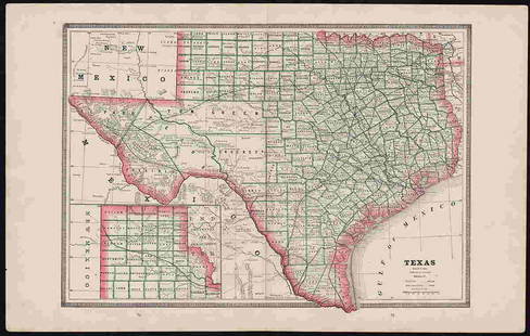
2017George Cram: Map of Texas, 1883Map: Texas Cartographer: George F. Cram Publisher: George F. Cram Co. Published: Chicago, 1883 Size: 11.75 x 17 inches Wonderful authentic antique map of Texas published in 1883 by George F. Cram. PriSee Sold Price
Sold20201883 c. Cram Map of Austria-Hungary -- Austria-HungaryTitle: 1883 c. Cram Map of Austria-Hungary -- Austria-Hungary Cartographer: G Cram Year / Place: 1883 c., Chicago Map Dimension (in.): 8.3 X 11 in. This is a nice map of Austro-Hungarian Empire. It exSee Sold Price
Sold20201883 c. Cram Map of Austria-Hungary -- Austria-HungaryTitle/Content of Map: 1883 c. Cram Map of Austria-Hungary -- Austria-Hungary Cartographer: G Cram Year/Place: 1883 c., Chicago Size: 8.3 X 11 in. This is a nice map of Austro-Hungarian Empire. It exisSee Sold Price
Sold2024George F. Cram - Historical Map of Pittsburgh Allegheny PennsylvaniaHistorical Map of Pittsburgh Allegheny Pennsylvania - Cram 1892.Size: 54 cm x 33 cmSee Sold Price
Sold2024Crams Township and Railroad Map of Pennsylvania-1898This is a Crams Township and Railroad Map of Pennsylvania dated 1898. Booklet contains an excellent multi-paneled fold-out map of the state of Pennsylvania that shows and lists all railroads in the stSee Sold Price
Sold20221883 Hardesty Map of Pennsylvania -- Map of PennsylvaniaTitle: 1883 Hardesty Map of Pennsylvania -- Map of Pennsylvania Cartographer: H Hardesty Year / Place: 1883, Chicago Map Dimension (in.): 12.8 X 19.4 in. This is an excellent map of Pennsylvania. GreaSee Sold Price
Sold2017150 plus loose plates from Breou's Farm Maps of Chester150 plus loose plates from Breou's Farm Maps of Chester County, Pennsylvania, WH Kirk, Philadelphia, 1883, with a bindingSee Sold Price
Sold2017Breou's Farm Maps of Chester County, Pennsylvania, WHBreou's Farm Maps of Chester County, Pennsylvania, WH Kirk, Philadelphia, 1883, unbound at spine, edges good-very good, full, boards fair-good, but may not contain all platesSee Sold Price
Sold2017Breou's Farm Maps of Chester County, Pennsylvania, WHBreou's Farm Maps of Chester County, Pennsylvania, WH Kirk, Philadelphia, 1883, taped at spine, edges good-very good, full, boards fair-good, but may not contain all platesSee Sold Price
Sold2017Breou's Farm Maps of Chester County, Pennsylvania, WHBreou's Farm Maps of Chester County, Pennsylvania, WH Kirk, Philadelphia, 1883, intact spine, edges good-very good, full, boards fair-good, but may not contain all platesSee Sold Price
Sold2017Breou's Farm Maps of Chester County, Pennsylvania, WHBreou's Farm Maps of Chester County, Pennsylvania, WH Kirk, Philadelphia, 1883, unbound at spine, edges tattered, losses to boards, full, but may not contain all platesSee Sold Price
Sold20161930s Crams Superior Pennsylvania School Wall MapDESCRIPTION: George Cram Markable-Washable Superior Pennsylvania school wall map. With census, regions, and population information at bottom. Printed by George Cram Co. Indianapolis, Indiana. MEASUREMSee Sold Price
Sold2022Clean 1883 RR map of Texas, Geo. F. CramInteresting cerographic map of Texas from Cram’s Unrivaled Family Atlas of the World. Predates subdivision of Tom Green, Pecos, Crockett and Presidio Counties. Shows rail system throughout statSee Sold Price
Sold2019Scarce Cram map of MontanaThis large, 2-page map of Montana, with the yellow and carmine color scheme, is much scarcer than the green and rose versions in later 1883 and 1884 Cram atlases. Created at a time when the West was sSee Sold Price
Sold2020Scarce 1883 map of TexasExtremely scarce early 1883 map is different from the more common later 1883 and 1884 version of Cram’s Texas. The later versions have green county borders with rose hachures for the state outline.See Sold Price
Sold20201883 Map of New York CityAuthor: Cram Title: 1883 Map of New York City Medium: Ink on Paper Dimensions: 21.5"X13.5" Map of New York City dated 1883. Engraved and published by George Cram in Chicago. Double folio map. Key loweSee Sold Price
Sold2021Scarce variant map of New York, Cram 1883Title: Scarce variant map of New York, Cram 1883 Description: In the year 1883, George F. Cram published at least two versions of his Unrivaled Family Atlas. The first version contained maps with roseSee Sold Price
Sold2020Large Map of PennsylvaniaMap of Pennsylvania With map of New Jersey [and] Maryland Delaware and Baltimore County on versos Cartographer: George Franklin Cram Dated: Circa 1900See Sold Price
Sold20211883 Map of MontanaAuthor: Cram Title: 1883 Map of Montana Medium: Ink on Paper Dimensions: 21.5"X14" Map of Montana dated 1883. Printed and published by George Cram in Chicago. Part of his Family Atlas. Double folio maSee Sold Price
Sold20211883 Map of the US Southern StatesAuthor: Cram Title: 1883 Map of the US Southern States Medium: Ink on Paper Dimensions: 22"X13.5" Map of the Southern states dated 1883. Engraved and published by George Cram in Chicago. It captures ASee Sold Price
Sold20211883 Map of ColoradoAuthor: Cram Title: 1883 Map of Colorado Medium: Ink on Paper Dimensions: 13.5"X11" Map of the Colorado dated 1883. Printed and published by George Cram in Chicago. Part of his World Atlas. Key lowerSee Sold Price
Sold20211883 Map of the United StatesAuthor: Cram Title: 1883 Map of the United States Medium: Ink on Paper Dimensions: 21"X14" Map of the US dated 1883. Engraved and published by George Cram in Chicago. Double folio map. Color coded forSee Sold Price
6 days LeftJasper52CENTRAL ASIA. Bokhara Russian Turkestan Tomsk Great Horde Turgan. LETTS 1883 mapUS$8
Jun 06Freeman's | HindmanSTEVENSON, Robert Louis (1850-1894). Treasure Island. London, Paris & New York: Cassell & Company,US$1,500
5 days LeftJasper521892 Black Map of US New England to New York, Pennsylvania, New Jersey and Canadian Maritimes plusUS$85
May 30Forum AuctionsStevenson (Robert Louis) Treasure Island, first edition, first issue, 1883.£1,000
5 days LeftJasper521822 MAP of SOUTH AMERICA GEOGRAPHICAL STATISTICAL HISTORICAL antique 17.5x 22"US$75
5 days LeftJasper521822 MAP of LEEWARD ISLANDS GEOGRAPHICAL STATISTICAL HISTORICAL antique 17.5x22"US$120


![Large Map of Pennsylvania: Map of Pennsylvania With map of New Jersey [and] Maryland Delaware and Baltimore County on versos Cartographer: George Franklin Cram Dated: Circa 1900](https://p1.liveauctioneers.com/5614/183569/92295179_1_x.jpg?height=310&quality=70&version=1603822607)


![Untitled. Midwest. [Map Issued With the Official Inter-State Railway Guide] (1 of 1)](https://p1.liveauctioneers.com/5584/329422/177662238_1_x.jpg?height=282&quality=70&version=1715717898)


