Sold2022Keren Hayesod Poster - Israel's Independence DayPoster by Keren Ha-Yesod for Israel's Independence Day, designed by Franz Kraus. Dimensions: 68X47 cm. A mended tear on the upper part and minute tears on the borders of the sheet.See Sold Price
Sold2022Keren Hayesod Poster - Day of Immigration and Settlement"Yom HaAliyah VeHaHityashvut" [Day of Immigration and Settlement], poster issued by Keren Hayesod. [Tel-Aviv]: Lith. "Aviva", 1950. Design: [David] Schneuer (signed in the plate).Illustrated poster isSee Sold Price
Sold2021San Diego with pictorial recreation map 1935Heading: (California - San Diego) Author: Title: Map of San Diego California City and County - with two maps, one a pictorial bird's-eye map Place Published: [San Diego] Publisher:Lowell E. Jones <See Sold Price
Sold2022Keren Hayesod PostersLot of 3 Keren Hayesod posters, 1950s. Dimensions: 47X68-69X49 cm. Overall good condition, minor tears and folding lines.See Sold Price
Sold2022Keren Hayesod PostersLot of 3 Keren Hayesod posters, 1940s-1950s. Dimensions: 48X64-69X49 cm. Overall good condition, minor stains and tears to two "Shabbat" posters.See Sold Price
Sold2019MAP - Jerusalem, Holy Land. DanckertsJerusalem, Holy Land. Cornelius Danckerts, De Stadt Ierusalem, 1718 (published). Hand Color. Great bird's-eye plan of the ancient holy city flanked by engravings of religious icons. At the bottom areSee Sold Price
Sold2021Wright, Paul 1782 Holy Land Map. Jerusalem"A Correct Plan of the Antient City of Jerusalem" by Thomas Conder. Folio Copper Plate Published 1782, London for "The Complete British Family Bible…" by Paul Wright. Paper Size: 14.5 x 9.5 inch (37See Sold Price
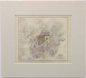
Sold2023Wright, Paul 1782 Folio Holy Land Map. Jerusalem City"A Correct Map of the Antient City of Jersusalem and Parts Adjacent" Folio Copper Engraved Map Published 1782, London for "The Complete British Family Bible…" by Paul Wright. Drawn and Engraved by TSee Sold Price
Sold2018Medallion of Herzl issued by Keren HayesodMedallion of Herzl issued by Keren HayesodSee Sold Price
Sold20221850 Survey of Holy Land MAPS Jerusalem Bethlehem Canaan Bible Nativity Israel1850 Survey of Holy Land MAPS Jerusalem Bethlehem Canaan Bible Nativity Israel J.T. Bannisters “Survey of the Holy Land” is a rare, mid-19th-century history of Israel and Palestine. In thiSee Sold Price
Sold2015Letter by Rabbi Kook* Letter by Rabbi Dr. Yisrael Lowenthal to Rabbi Avraham Yitzchak HaCohen Kook. Jerusalem, [1935]. (Includes postal envelope). * three leaves [4 pages] with the typewritten draft of Rabbi Kook's respoSee Sold Price
Sold2017Map of Jerusalem and Its Ruins, 1872Map: Jerusalem and Its Ruins Maker: Redding & Co Date: 1872 Size: Folio, 15.3 inches high x 19.75 inches wide Detailed plan of ancient biblical sites in the Holy City. Fine, Large Plan of Jerusalem PlSee Sold Price
Sold2016Modern Jerusalem, 1858Map: Jerusalem before the Roman Destruction Publishing: Sarony & Major, 1858 Medium: Hand colored lithograph Size: 13.5 x 15 inches Napoleon Sarony (1821-1896) was an American lithographer and a highlSee Sold Price
Sold2017I.H. Coccejo / Weigel: Map of Jerusalem, 1720Map: Jerusalem, "Ierusalem aus den Schrifften Iosephi" Cartographer: I.H. Coccejo. / Weigel Place & Date: Nuremberg / 1720 Size: 16 5/8" x 13" Condition: original color; overall age toning and minor sSee Sold Price
Sold2016Share Certificate - "Torah veDerech Eretz", Jerusalem,Share certificate, "Torah veDerech Eretz Social Union" Ltd, Jerusalem. 1935. 26.5X21 cm. Good condition. Stains. staple marks.See Sold Price
Sold2021Jerusalem & Palestine 1889Title/Content of Map: Jerusalem & Palestine 1889 Date Printed: 1889 Material/Medium: Paper Size: approx 11x14 inches Mast, Crowell & Kirkpatrick, Peerless Atlas of the World Reserve: $30.00 Shipping:See Sold Price
Sold2022Teudat Aliya of Leo Maier, Lodz-Trieste –Jerusalem, 1935Teudat Aliya of Leo Maier, Lodz - Trieste –Jerusalem, 1935 Leo Maier and his family arrived to Jerusalem on ship from Trieste, with tax stamp of KKL 4 filled pages, size: 16 x 9.5 cm.See Sold Price
Sold2020Jerusalem - BirdTitle/ Content of Map:Jerusalem - Bird's Eye View Date Printed: 1983 Cartographer: Aharon Bier Material/Medium: paper Dimensions: Approx. 16x20, olded size approx. 4"x10". Additional Information: ApprSee Sold Price
Sold20211758 History of Saladin Egypt Sultan Crusades MAPS1758 History of Saladin Egypt Sultan Crusades MAPS Jerusalem Ptolemais Israel Saladin was a 12th-century sultan, known for being the first sultan of Egypt and Syria. His reign was highlighted by his mSee Sold Price
Sold2017Florimi Map of Jerusalem and Christ Crucifiction, 1595Map: 1595 Florimi Map of Jerusalem and Christ Crucifiction -- L'Antichissima citta di Gierusalemme come era nel tempo di N. S. Gisu Christo con le sur cechiaratione Cartographer: M. Florimi Year / PlaSee Sold Price
Sold20221590 Map of Jerusalem from "Civitates Orbis Terrarum" by Hogen & Bran1590 Map of Jerusalem from "Civitates Orbis Terrarum" by Hogen & Bran 1p, measuring 21" x 16", [Cologne, Germany], undated [Ca. 1590]. A beautiful color copper etching map of Jerusalem, printed inSee Sold Price
Sold2018Map of Jerusalem - Engraving - Cologne, 1575Hierosolyma, Urbs Sancta. Ludeae, Totiusque Orientis Longe Clarissima, Qua Amplitudine Ac Magnificentia Hoc Nostro Aevo Conspicua Est. Map of Jerusalem - engraving from Georg Braun and Frans HogenburgSee Sold Price
Sold2022Panoramic Map of Jerusalem Book - 1845Panoramic Map of Jerusalem and the Adjacent Towns and Villages, from a drawing by the Librarian of the Armenian Convent. Drawn from the original and engraved by Nathaniel Whittock. Bound in a book thaSee Sold Price
Jun 23Schilb Antiquarian Rare Books1870 BEAUTIFUL Life of Jesus Christ Fleetwood Bible ART Miracles Jerusalem MapUS$34(2 bids)
Jun 23Schilb Antiquarian Rare Books1790 Life of Jesus Christ Fleetwood Bible ART Miracles Jerusalem MAP Holy LandUS$42(2 bids)
Featured5 days LeftJasper52Asia 610 AD Persia Chenla Tzinitza Silla Yamato. Zemarchos Hsuan-tsang 1935 mapUS$30
5 days LeftJasper52China & East Asia. Political Ethnic Racial Linguistic. Chinese Aryans 1935 mapUS$25
5 days LeftJasper52Asia c750AD Chin Machin Chen-la Tu-fan Caliphs Empire pilgrim routes 1935 mapUS$30
6 days LeftSloans & KenyonMAP OF CONNECTICUT SHOWING PRINCIPAL HIGHWAYS, WITH ILLUSTRATIONS BY JOHN HELD JR AND HISTORICUS$350
5 days LeftJasper52ASIA. Political. Shows West Bank under Jordanian occupation.BARTHOLOMEW 1952 mapUS$15
May 30Forum AuctionsJudaica.- Israeli Defense Force (Educational Department) [Plan of The Temple Mount, or Haram£400
4 days LeftJasper521738 BIBLE in DUTCH ILLUSTRATED w/ MAPS MASSIVE FOLIO in DUTCH antique BIBLIAUS$600
5 days LeftConcept Art Gallery2 Arctic books signed by Richard E. Byrd Alone and DiscoveryUS$50(2 bids)
5 days LeftConcept Art GalleryLithographs of Marc Chagall II complete with 11 lithos and DJUS$350(2 bids)
2 days LeftUkiyoe Gallery Japanese Woodblock PrintsHasui Kawase: Rain at Lakeside Teahouse 1935 WoodblockUS$1,300(6 bids)


![Keren Hayesod Poster - Day of Immigration and Settlement: "Yom HaAliyah VeHaHityashvut" [Day of Immigration and Settlement], poster issued by Keren Hayesod. [Tel-Aviv]: Lith. "Aviva", 1950. Design: [David] Schneuer (signed in the plate).Illustrated poster is](https://p1.liveauctioneers.com/3506/261051/135897141_1_x.jpg?height=310&quality=70&version=1662650556)
![San Diego with pictorial recreation map 1935: Heading: (California - San Diego) Author: Title: Map of San Diego California City and County - with two maps, one a pictorial bird's-eye map Place Published: [San Diego] Publisher:Lowell E. Jones <](https://p1.liveauctioneers.com/642/218849/112379283_1_x.jpg?height=310&quality=70&version=1631923877)


![Letter by Rabbi Kook: * Letter by Rabbi Dr. Yisrael Lowenthal to Rabbi Avraham Yitzchak HaCohen Kook. Jerusalem, [1935]. (Includes postal envelope). * three leaves [4 pages] with the typewritten draft of Rabbi Kook's respo](https://p1.liveauctioneers.com/1980/73289/37821554_1_x.jpg?height=310&quality=70&version=1434371622)


![1590 Map of Jerusalem from "Civitates Orbis Terrarum" by Hogen & Bran: 1590 Map of Jerusalem from "Civitates Orbis Terrarum" by Hogen & Bran 1p, measuring 21" x 16", [Cologne, Germany], undated [Ca. 1590]. A beautiful color copper etching map of Jerusalem, printed in](https://p1.liveauctioneers.com/6306/250544/130128283_1_x.jpg?height=310&quality=70&version=1654115529)


