Sold2019* SPEED, John (1552-1629). Holy Iland / Garnsey / Farne* SPEED, John (1552-1629). Holy Iland / Garnsey / Farne / Iarsey. [London,] 1610 [but 1676]. Hand-colored engraved map of Holy Island and Lindisfarne off the Northumberland Coast, and Guernsey and JerSee Sold Price
Sold2018Southwell & G. Rollos 1774 Pair of Holy Land Maps"A Map of the Land of Canaan" and "A Map of the Situation of the Garden of Eden" Copper Engraved Maps Published 1774, London for "The Universal Family Bible: Or, Christian's Divine Library" by the RevSee Sold Price
Sold2024Robert Benard - pitcairn map - 1774The Map of Pitcairn Island, by expedition of James Cook by French engraver Robert BenardSize 32,5 x 35,5See Sold Price
Sold2015Carne (John) - Syria, The Holy Island, Asia Minor,3 parts in one, additional engraved titles, 117 engraved plates, 2 engraved maps, tissue guards, a little minor spotting and light finger-marking but overall internally clean and bright, contemporarySee Sold Price
Sold2019Collins, William (Pub) C1870 Pair of HC Holy Land Maps"Geography of the Hebrews" and "Canaan in Possesion of the Twelve Tribes of Israel" Hand Coloured Steel Engraved Map Published C1870 by William Collins, London & Glasgow for "The Holy Bible" Paper SizSee Sold Price
Sold2024James Cook - Map / Chart Of The Island TahitiEngraved nautical map from the 1774 first French edition of the first map of New Zealand, illustrating Lieutenant James Cook's 1769 exploration of the passage between New Zealand's North and South islSee Sold Price
Sold2024James Cook - Map of Tahiti, the Society Islands, and the VicinityEngraved nautical map from the 1774 first French edition of the first map of New Zealand, illustrating Lieutenant James Cook's 1769 exploration of the passage between New Zealand's North and South islSee Sold Price
Sold2021Germany's Baltic coast Pomeranian region, RARETitle: Germany's Baltic coast Pomeranian region, RARE Swedish issue by A. Akerman 1768-1774. Date/Period: 1768-1774 Materials: Copperplate engraved Size: 7 1/2 x 6” Rare map shows the island RugSee Sold Price
Sold2019Maps 19th Cent. Mixed Lot of 6Lot of 6 Steel Engraved Maps. Incl Persia, Holy Land, Battle of Alma, Scotland, and England/Wales. Examples by Chambers, SDUK, William Collins, Weller and Rapkin. Paper Size: Up to 16 x 13.5 inch (40See Sold Price
Sold2016James Cook, Carte Des Decouvertes Mer PacifiqueAn engraved map / chart of the Pacific Islands, Carte Des Decouvertes faites dans la Mer Pacifique, Commande par le Capitaine Cook, en 1774. Authored by Captain James Cook in 1774, with Nouvelle CaledSee Sold Price
Sold2021Holy land. RARE Swedish issue by A. Akerman 1768-1774Title: Holy land. RARE Swedish issue by A. Akerman 1768-1774 Date/Period: 1768-1774 Materials: Copperplate engraved Size: 7 1/2 x 6”. Scarce map shows the divisions of the region. 1768-1774. By AnSee Sold Price
Sold2019Maps 19th Century Mixed Lot of 10Incl Holy Land, South America, West Indies, Scandinavia, Armenia, India and a Mountain Chart. Examples by Weller/Bryce, Hughes, William Collins, Encyclopaedia Britannica and Cornwell/Dower. Paper SizeSee Sold Price
Sold2016Caribbean Island Map, by Mount & Page, 1720 (rare &Spectacular sea chart of the Spanish Main to Puerto Rico, from Mount & Page's English Pilot, Fourth Book. Known as the most important English Atlas of Sea Chart covering the Mediterranean and North AmSee Sold Price
Sold2023Vintage 14K Gold Nantucket Island Map Pendant NecklaceVintage 14K Gold Nantucket Island Map Pendant Necklace, the reverse marked "14K", the chain marked "Italy 14K Aurea". Chain length 14 in. Width of pendant .9 in. Weight 3.7 dwt.See Sold Price
Sold2021George Cress Watercolor Landscape PaintingGeorge Ayers Cress (Alabama/Tennessee, 1921-2008) expressionist mixed media landscape painting titled "Island Map". Signed and dated 1967 lower left. Additionally signed and titled en verso. Housed inSee Sold Price
Sold2023MAP OF THE MARITIMES BY CLARA CAIEThe "Nova Scotia, New Brunswick and Prince Edward Island" map, artistically drawn by Clara Caie (1874-1955), granddaughter of ship owner Samuel Killan, Yarmouth, Nova Scotia. The neatness, accuracy anSee Sold Price
Sold20201925 Tony Sarg Nantucket Island Box1925 Tony Sarg (1880-1942) Nantucket Island Decorated Covered Box, with Sankaty Head Light and Island Map, "Green Umbrella Nantucket" label on bottom. 2 ¼ in. x 10 in. x 8 in.See Sold Price
Sold202370304: A Marshall Islands Navigation Map Micronesia, 1A Marshall Islands Navigation Map Micronesia, 19th century Constructed of coconut palm leaf midribs and shells. Such maps or charts were for navigating specific atolls and islands in MicrSee Sold Price
Sold20213PC Kentish Guards Wool CoatsRhode Island,Circa 1774 Includes three thick wool coats with brass buttons marked "KG 1774" down the front. Each coat approx. 59" wingspan x 14" chest x 44" long. ..Wool, textile From the collection oSee Sold Price
Sold2019Two Johann Baptist Homann (1661-1774) Maps, "VirginiaTwo Johann Baptist Homann (1661-1774) Maps, "Virginia Marylandia et Carolina in America Septatrionalis," c. 1720, hand colored, H.- 23 in., W.- 19 in. (2 Pcs.)See Sold Price
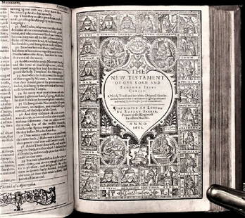
Sold20201612 King James Holy Bible, Genealogy / Map of CanonTHE HOLY BIBLE 1612 This is a very rare 1612 Quartos as there were very few produced to make ready for the 1613 Quartos.See Sold Price
Sold2016c. 1670 Engraved Holy Land + Mediterranean MapHistoric Maps c. 1670 Engraved Map of the Holy Land & Mediterranean Sea c. 1670, Historic Hand-Colored Engraved Map entitled: “Terra Sancta sive Promissionis olim Palestina recens delineata,” by FSee Sold Price
Sold2022JOHN SENEX CALIFORNIA AS ISLAND 1720 ENGRAVED MAPOriginal engraved map of North and South America featuring California depicted as an island. Dimensions: (Frame) H 24.25" x W 27.75" (Sight) H 20" x W 23.25" Condition: Paper with center fold as issueSee Sold Price
Sold20181796 State of Rhode Island Hand Colored MapNew York,Dated 1796 Map of the State of Rhode Island as updated by the latest surveys,1796, hand colored on laid paper, engraved for the American edition of Winterbothams America, published by John ReSee Sold Price
18 hrs LeftAdam's AuctioneersSEWEL William The History of the Rise, Increase and Progress of the Christian People called€50
5 days LeftBidhausHermes HERMES Calvi Verso Card Case Nata Vaux Swift Chevre Misor U Engraving Cream White Bicolor SeaUS$5
May 14Akiba Galleries(2 Pc) Allain Manesson Mallet Description De L'Univers 2 Vol. German TranslationUS$200(1 bid)
4 days LeftTrillium Antique Prints & Rare BooksPtolemy & Magini, pub. 1620 - Map of Taprobana, Island in SumatraUS$50
1 day LeftJasper52Carte des Isles des Amis. Friendly or Tonga Islands. Tongatapu. BONNE 1788 mapUS$30
1 day LeftJasper52Carte de l'Isle de Bourbon, autrefois Mascareigne'. Réunion. BELLIN 1750 mapUS$70(1 bid)
Featured1 day LeftJasper52New Zealand Sandwich Galapagos Islands. Papuan Archipelago. Melanesia 1860 mapUS$130(1 bid)
Featured8 hrs LeftJasper52RARE MAP, 1762, 15 Cities of the Safavid era Persian Empire by J. B. HomannUS$600
May 16Potter & Potter AuctionsMap to Acquaint You with the Great Mission Bay Project. 194...US$125(1 bid)


![* SPEED, John (1552-1629). Holy Iland / Garnsey / Farne: * SPEED, John (1552-1629). Holy Iland / Garnsey / Farne / Iarsey. [London,] 1610 [but 1676]. Hand-colored engraved map of Holy Island and Lindisfarne off the Northumberland Coast, and Guernsey and Jer](https://p1.liveauctioneers.com/197/138502/70223743_1_x.jpg?height=310&quality=70&version=1553021481)