Sold2022Ernest Dudley Chase, Map of Boston vicinityErnest Dudley Chase, Map of Boston vicinity. Pencil signed by publisher, Copyright 1938 Jordan Marsh label on back. Jordan Marsh (officially Jordan Marsh & Company) was an American department store chSee Sold Price
Sold2018Signed Ernest Dudley Chase 1945 pictorial map of NorthTitle: A Pictorial Map of North America Map maker: Ernest Chase Dudley Place and Year: Winchester, 1945 Dimensions: 68.2 x 50.2 cm (26.9 x 19.8 in) Technique: Offset printing Coloring: Original printeSee Sold Price
Sold2023Vintage Marshall Fields's Ernest Dudley Chase Italy Color Colortext MapVintage Marshall Fields's Ernest Dudley Chase Colortext Publications Chicago Italy Color Map framed under glass. Measurements in inches: 15 x 18, image: 12 x 15 Condition:Good with no problems ShippinSee Sold Price
Sold2022CHASE, Ernest Dudley (1878-1966). America the Wonderland. A...CHASE, Ernest Dudley (1878-1966). America the Wonderland. A Pictorial Map of the United States. 1941. Published and copyrighted by Ernest Dudley Chase of Winchester, Mass. Color pictorial map of the USee Sold Price
Sold20211939 Chase Pictorial Map of World's Wonders -- WorldTitle: 1939 Chase Pictorial Map of World's Wonders -- World Wonders A Pictorial Map Designed and Drawn by Ernest Dudley Chase of Winchester, Massachusetts Cartographer: E D Chase Year / Place: 1939 c.See Sold Price
Sold20221941 Dudley US Pictorial Map -- America the Wonderland.Title: 1941 Dudley US Pictorial Map -- America the Wonderland. A Pictorial Map of the United States. Designed and Drawn by Ernest Dudley Chase of Winchester, Massachusetts Cartographer: E D Chase YearSee Sold Price
Sold2023CHASE, Ernest Dudley (1878-1966). Two pictorial maps of Ame...CHASE, Ernest Dudley (1878-1966). Two pictorial maps of America. Includes: America the Wonderland / A Pictorial Map of the United States. 1954. Philadelphia: The Inquirer Colorama. Color pictorial mapSee Sold Price
Sold2024Signed & FramedPictorial Map Of The New England States Designed & Drawn By Ernest Dudley ChaseThis lot contains a Signed & Framed Print Pictorial Map Of The New England States Designed & Drawn By Ernest Dudley Chase . The frame is approx 26 1/2" x 20 3/4" while the map is approSee Sold Price
Sold2018World War II Victory MapVictory in the Pacific. A pictoral map. Designed and published by Ernest Dudley Chase, Winchester Mass. Matted and framed Good condition S: 15.5 x 23.5 F: 26.5 x 34.5See Sold Price
Sold20231939 Chase World Pictorial Map - World Wonders A Pictorial Map Designed and drawn by Ernest DudleyTitle: 1939 Chase World Pictorial Map - World Wonders A Pictorial Map Designed and drawn by Ernest Dudley Chase Cartographer: E D Chase Year / Place: 1939 Map Dimension (in.): 27.5 X 17.5 in. This supSee Sold Price
Sold2018Earnest Dudley Chase, "America the Wonderland" MapEarnest Dudley Chase (1878-1966) America the Wonderland map - 1941, including dozens of vignettes of buildings around the US Signed on lower left "E. Dudley Chase" Approx. 21" x 27.5"See Sold Price
Sold2020Pictorial Map of GermanyPrint on board. Copy right 1935, E Dudley Chase. Signed in pencil lower left.All sales are subject to Bremo Auctions Terms & Conditions. Please review before bidding.See Sold Price
Sold2022Ernest Dudley Heath. Watercolor. Sgd.British. 1886-1930. Signed and Dated 1885. . Original watercolor probably for a novel publication. Entitled "And Throws Herself into the Arms of a Woman". Nicely framed. Size 9" x 7"See Sold Price
Sold20231942 Chase Pictorial Map of South America -- The Good Neighbor; Pictorial Map of South AmericaTitle: 1942 Chase Pictorial Map of South America -- The Good Neighbor; Pictorial Map of South America Cartographer: E D Chase Year / Place: 1942, Wincester, MA Map Dimension (in.): 27.5 X 20.3 in. ThiSee Sold Price
Sold2021J. Chase 1856 Map of Kennebec County Maine.57 x 58 inches, losses to top of map, top bar partially detached. Philadelphia and Boston: J.L. Smith, 1856See Sold Price
Sold2023Twelve Framed British MapsA set of twelve framed British maps, circa 1940-1950, designed and drawn by Ernest Clegg, each map is framed. Dimensions:Sight 17 x 22in; frame 18 1/2 x 23 1/2in.See Sold Price
Sold2024MAP, South Africa, UllmannSouth Africa. Ernest Ullmann, Tourist Map of South Africa, 1937 (dated). Printed Color. This charming tourist map of South Africa was created by Ernest Ullmann for the Publicity and Travel DepartmentSee Sold Price
Sold2017Winnie-the-Pooh 1/350 large paper signedHeading: Author: Milne, A.A Title: Winnie-the-Pooh Place Published: London Publisher:Methuen Date Published: [1926] Description: xi, [3], 158, [2] pp. Illustrated by ErnestSee Sold Price
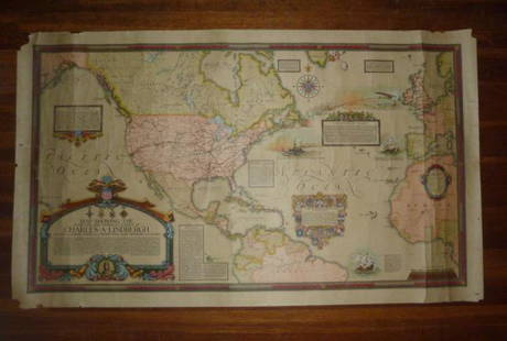
Sold2021Charles Lindberg Authentic Clegg World flight Map1928 Authentic Original Ernest Clegg Charles Lindberg Flight Map. Map was Designed by Ernest Clegg in 1928 . Map Title is “ Map Showing the Overland and Overseas Flights of Charles A. LindbergâSee Sold Price
Sold20171960's Whom He Bell Tolls Yugoslavian PosterThis is a 19.5" x 27" Yugoslavian poster for the 1943 Sam Wood film For Whom the Bell Tolls based on the 1940 novel of the same title by Ernest Hemmingway, screenplay by Dudley Nichols and starring GaSee Sold Price
Sold2021Murphy Style Arts & Crafts Gilt FrameAmerican ca. 1910. Hand carved and gilded, possibly by Hermann Dudley Murphy, bears Sotheby's labels for Ernest Lawson verso, in a great standard size. Rabbet: 16" x 20" Overall Dimensions: 26 1/2" xSee Sold Price
Sold2021Rare map of private NY sporting reserve 1887Heading: (New York - Tuxedo Park) Author: Bowditch, Ernest W. Title: Tuxedo Park Orange County New York. May, 1887 Place Published: New York Publisher:Endicott & Co. Photo Lith. Date Published: <See Sold Price
Sold2022Dudley Sea Chart of DenmarkDUDLEY, Sir Robert (1574-1649). [Denmark] Carta particolare che comincia con il gran fiume Albis e contene parte dell mare Baltico e Ientrata al sondo di Danemarca... Engraved map. Florence, 1646.20 7See Sold Price
Sold2022Dudley Sea Chart of ArgentinaDUDLEY, Sir Robert (1574-1649). [Argentina] Carta particolare della costa di America Australe che comincia al C. di Matas sin al C. di Galegos. Engraved map. Florence, 1646. 20 7/8" x 16 1/8" sheet. SSee Sold Price
3 days LeftNY Elizabeth ERNEST FLOYER'S 1882 UNEXPLORED BALUCHISTAN ANTIQUE MAP ILLUSTRATED IN ENGLISHUS$50
Jun 08Leon GalleryRobert Dudley (1573 - 1649) - Carta particolare del'Isola Mindano parte Australe con Celebes e₱500,000
2 days LeftCedarburg Auction & Appraisals LLCSet of Four Maps Showing All of Spain and Portugal c. 1700'sUS$450(2 bids)
6 days LeftBroward Auction GalleryErnest Peixotto (CA,NY,French,1869-1940) oil painting antiqueUS$50(2 bids)
2 days LeftCedarburg Auction & Appraisals LLCRare 1877 Double sided map of Milwaukee and WisconsinUS$80(6 bids)
6 days LeftTremont AuctionsNew York Classical carved mahogany sofa in the manner of Duncan Phyfe, possibly Ernest Hagen, NewUS$300
6 days LeftCarlsen Gallery, Inc.GRANT WOOD, JANUARY 1936 SGND LOWER RIGHT EDITION OF 250 (9" X 11 7/8") PROV. ERNEST KRAMERUS$1,000
4 days LeftFreeman's | Hindman[HEMINGWAY, ERNEST (1899-1961)]. Hemingway's Rolleiflex MX camera.US$2,000


![Winnie-the-Pooh 1/350 large paper signed: Heading: Author: Milne, A.A Title: Winnie-the-Pooh Place Published: London Publisher:Methuen Date Published: [1926] Description: xi, [3], 158, [2] pp. Illustrated by Ernest](https://p1.liveauctioneers.com/642/102567/52412597_1_x.jpg?height=310&quality=70&version=1492019432)


![Dudley Sea Chart of Denmark: DUDLEY, Sir Robert (1574-1649). [Denmark] Carta particolare che comincia con il gran fiume Albis e contene parte dell mare Baltico e Ientrata al sondo di Danemarca... Engraved map. Florence, 1646.20 7](https://p1.liveauctioneers.com/1968/250616/130196505_1_x.jpg?height=310&quality=70&version=1654190895)
![Dudley Sea Chart of Argentina: DUDLEY, Sir Robert (1574-1649). [Argentina] Carta particolare della costa di America Australe che comincia al C. di Matas sin al C. di Galegos. Engraved map. Florence, 1646. 20 7/8" x 16 1/8" sheet. S](https://p1.liveauctioneers.com/1968/250616/130196501_1_x.jpg?height=310&quality=70&version=1654190895)


![[HEMINGWAY, ERNEST (1899-1961)]. Hemingway's Rolleiflex MX camera. (1 of 4)](https://p1.liveauctioneers.com/197/329785/177758515_1_x.jpg?height=282&quality=70&version=1715625218)