Sold2021Early English map of U.S. 1783Heading: Author: Kitchin, Thomas Title: Map of the United States in North America: with the British, French and Spanish Dominions adjoining, according to the Treaty of 1783. Place Published: London PSee Sold Price
Sold2022Antique 1719 English Map of the Chesapeake Bay by John SenexAntique early English map of the Chesapeake Bay, showing the principal settlements of this tobacco and cotton producing region. Engraved in London in 1719 by John Senex map is titled The Sea of VirginSee Sold Price
2019Early English road map by John OgilbyHeading: (Maps) Author: Ogilby, John Title: The Road from London to St. Neotts in Com. Hunt. Continued to Oakeham in Com Rutland Place Published: London Publisher: Date Published: 1675See Sold Price
Sold20222 PC. FRAMED EARLY ENGLISH MAPS2 PC. FRAMED EARLY ENGLISH MAPS: Comprising; 1- Hand-colored Oxford Shire map, by Robert Morden. 1- An accurate map of the county of Bedford divided into its hundreds. Drawn from a late survey, & illuSee Sold Price
Sold2019Four Early Pewter PlatesAll measure approx 8"dia. All are stamped with early English or London markings on the back, one has an old solder repair and all have common wear of age and usage.See Sold Price
Sold2024EARLY ANTIQUE ENGLISH "SIMMS LONDON" SILVERED BRASS COMPASSEARLY ANTIQUE ENGLISH "SIMMS, LONDON" SILVERED BRASS COMPASS - 4 FOLDING SIGHTS, MAHOGANY BASE AND LID - MEASURES APPROX. 6 3/4" X 7" - CIRCA 1830See Sold Price
Sold20201684 Theory of the Earth by Burnet, 1st Ed, Folding Map1684 Theory of the Earth by Burnet, First English Edition, Folding Maps London 1684 First English Edition of this classic by Thomas Burnet WITH a fold MSee Sold Price
Sold2019Antique marine surveyors brass sextantOn ebony frame with natural inlay, makers mark H. Hemsley, London, English, early 19th C. With fitted mahogany case baring paper label for Charles Piers, Chronometer & Matchmakers,Liverpool. H 30.5cmSee Sold Price
Sold2024James Stark (1794-1859)James Stark (1794-1859) Charcoal Burning, Allerton Park, Yorkshire titled in pencil lower right watercolour 24 x 30cm Exhibited: Alpine Gallery, London, Early English Watercolours, No. 68 48 x 52cm frSee Sold Price
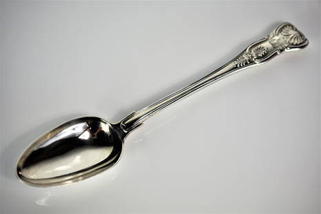
Sold2021Early English Silver Serving Spoon London C1840Includes an early Victorian English silver King's pattern serving spoon; London, 1840. DBL-Struck by Mary Chawner and Geo Adams, heavy gauge, measures approx. 12"l. Weighs approx. 6.4 OZTProvenance: DSee Sold Price
Sold20172 Antique English Etchings London Map & Hen w Chix2 Antique English Etchings, one is a B.R. Davies drawn London Map from 1843 & one is a Hen with Chicks, from a series by Fores, painted by J.F. Herring. Hen measures 25 x 27 inches. Both nicely framedSee Sold Price
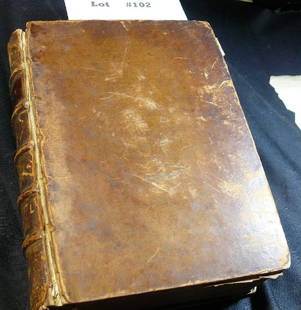
Sold2017EARLY ENGLISH LEATHER OLD & NEW TESTAMENT BIBLEEARLY ENGLISH LEATHER HOLY BIBLE . London: Impr. by Christopher Barker, 1585; The Booke of Common Prayer & Admin. of the Sacraments, & other Rites & Ceremonies of the Church Acc. to the Use of The ChuSee Sold Price
Sold2017Georgian Sterling Ladle, Serving Spoon and Meat SkewersEnglish (London), 18th-early 19th century. A group of three sterling meat skewers, dated ca 1784-1827, examples by George Smith III & William Fearn, William Sumner I and Charles Eley, a sterling fiddlSee Sold Price
Sold2020A LARGE EARLY 19TH CENTURY ENGLISH SILVER SALVER.A LARGE EARLY 19TH CENTURY ENGLISH SILVER SALVER. London 1821. 22.8 oz. 26.5 cm wide.See Sold Price
Sold20182 Early English Compasses2 Early English Compasses 1) Signed "Simms, London", silvered 4 9/10-inch dial, 4 folding sights, needle locks by closing the lid, mahogany base and lid, c. 1830. - And: 2) Brass, signed on the silveSee Sold Price
Sold2020Antigua labeled Antego. RARE early map.Title: Antigua labeled Antego. RARE early map. Description: c1732/1736 from the Atlas Minor by Herman Moll, London. VERY IMPORTANT early map of the island. Showing all the settlements and plantations.See Sold Price
Sold2021"KNIGHT OF TOUR-LANDRY", THOMAS WRIGHT.Translated from the original French into English in the reign of Henry VI and edited for the first time by Thomas Wright. Published in London for the Early English Text Society, by N. Trubner & Co., 1See Sold Price
Sold2022AN EARLY 19TH CENTURY ENGLISH SILVER POCKET WATCH. London 1804. 113 grams. 5.5 cm wide.AN EARLY 19TH CENTURY ENGLISH SILVER POCKET WATCH. London 1804. 113 grams. 5.5 cm wide.See Sold Price
Sold20162 early silver English pocket watches, 18th Century2 early silver English pocket watches, Wm. Webster, London 3054, hallmarked case, with key, winds but runs erratically, outer case has paper label "H. Tanis, Watchmaker& jeweler, 40 Main Street, PatteSee Sold Price
Sold2019English Sterling Silver Sugar. Burwash & Sibley. c 1811Early English Sterling Silver Covered Sugar hallmarked London 1811-1812, maker mark William Burwash & Richard Sibley. 5 1/4" t x 8 1/2" w x 4 3/4" d. Approx. 26.04 ozt. Very good condition.See Sold Price
Sold201918TH CENTURY LONDON TO HOLY HEAD ROAD ENGRAVINGEnglish road map engraving by John Ogilby "London to Holy Head" from 1735. Measures 27.5" x 23" w/ frame.See Sold Price
Sold201918TH CENTURY LONDON TO CARLISLE ROAD ENGRAVINGEnglish road map engraving by John Ogilby "London to Carlisle" from 1735. Measures 27.5" x 23" w/ frame.See Sold Price
Sold2021"THE GESTA ROMANORUM", SIDNEY HERRTAGE.Published for the Early English Text Society, by N. Trubner, London, 1879. Reedited version by Sidney JH Herrtage printed in early English. Includes a two page list of other publications for the SocieSee Sold Price
Sold2022Rees, Abraham 1820 Lot of 3 British MapsPlans of the Docks at Liverpool & London, Astronomy Map of the English Channel & England, and an Agricultural Plan. Copper Plates Published 1802-20 by Longman, Hurst, Rees & Orme for "The Cycloaedia:See Sold Price
3 days LeftThe Bidder AuctionsThe map of the railways in the Land of Israel - published by the Surveying Department of the BritishUS$30
3 days LeftNY Elizabeth ERNEST FLOYER'S 1882 UNEXPLORED BALUCHISTAN ANTIQUE MAP ILLUSTRATED IN ENGLISHUS$50
1 day LeftJasper521794 de la Rochette Map of the English Channel and Bay of Biscay -- A Chart of the British ChannelUS$240


![[Vale Press] (1 of 1)](https://p1.liveauctioneers.com/94/330664/178342402_1_x.jpg?height=282&quality=70&version=1716466933)


