Sold2023Early Map of Tennessee, Daniel Smith, 1795A MAP OF THE TENNASSEE [sic] GOVERNMENT FORMERLY PART OF NORTH CAROLINA TAKEN CHIEFLY FROM SURVEYS BY GENL. D. SMITH & OTHERS, drawn by Daniel Smith, engraved by Joseph T. Scott, for "General Atlas FoSee Sold Price
Sold2022Payne/Low, Map of Tennessee Government, 1799A MAP OF THE TENNASSEE[sic] GOVERNMENT FROM THE LATEST SURVEYS, 1799, engraved for John Payne's NEW AND COMPLETE UNIVERSAL GEOGRAPHY, published by John Low, New York, 1799. This early copperplate engrSee Sold Price
Sold2016A Map of the Tennassee Government, formerly part ofJohn Reid & W. Winterbotham. from the American Atlas. New York: J. Reid, L. Wayland & C. Smith, 1796. 2 Engraved Map Joined as Issued. 19 x 16 1/4 inchesSee Sold Price
Sold2023VERY RARE WALL MAP OF THE CITY OF BANGOR,PENOBSCOT COUNTY, MAINE. 1853, Bangor, Maine. "Published Under the Patronage of the City Government Henry F. Walling, Civil Engineer, 81 Washington St. Boston 1853". "S.S. Smith, Publisher 17 West MarSee Sold Price
Sold2023MAP, Tennessee, CareyCarey's Early Map of Tennessee. Tennessee. Mathew Carey, The State of Tennessee, from Carey's General Atlas, 1814 (circa). Hand Color. This fine map of Tennessee shows the state at an early point in iSee Sold Price
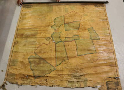
Sold2023[MAP]. SMITH, W.H., compiler. Smith’s Brooklyn Directory, f...[MAP]. SMITH, W.H., compiler. Smith’s Brooklyn Directory, for the Year Ending May 1st, 1857. Being a Directory of the Inhabitants with an Avenue and Street Guide, and an Appendix. Brooklyn: CharSee Sold Price
Sold2020[Map] Smith. Ould Virginia"Ould Virginia. A description of part of the adventures of Cap. Smith in Virginia." Circa early 1800s, on wove. Measured from neatlines 14" x 10.75". Right margin and lower margin trimmed within plateSee Sold Price
Sold20241795 Chart of Jersey and Guernsey, Sark, Herm and Alderney, FadenTitle/Content of Map: 1795 Chart of Jersey and Guernsey, Sark, Herm and Alderney, Faden Date Printed: 1795 Cartographer: William Faden Material/Medium: Engraving Size: 23.5 x 33" Beautiful double-pageSee Sold Price
Sold20201795 Pazzini Carli Map of Northern England -- ParteTitle/Content of Map: 1795 Pazzini Carli Map of Northern England -- Parte Settentrionale Dell' Inghilterra Cartographer: Pazzini Carli [family] Year/Place: 1795, Siena Size: 8.9 X 12.1 in. This is anSee Sold Price
Sold2017James K. Polk Ephemera, 6 itemsGroup of six (6) ephemera items related to President James K. Polk of Tennessee (1795-1849). 1st and 2nd items: 2 Photogravures of Polk, each with facsimile signature and remarque of his home in NashvSee Sold Price
Sold20201795 c. Robert de Vaugondy Map of the Holy Land --Title/Content of Map: 1795 c. Robert de Vaugondy Map of the Holy Land -- Judee ou Terre Sainte Cartographer: Robert de Vaugondy [Family] Year/Place: 1795 c., Paris Size: 9.8 X 8.8 in. This is an excelSee Sold Price
Sold2017Tanner: Antique Map of Tennessee, 1843Title/Content of Map: Tennessee by Tanner Date Printed: 1843 Cartographer: based on the work of H.C. Tanner Material/Medium: Paper Size: 17" x 14" Hand colored engraved Map. From the first edition pubSee Sold Price
Sold2017Bradford: Antique Map of Tennessee, 1838Title/Content of Map: Tennessee by Bradford Date Printed: 1838/1841 Cartographer: Thomas G. Bradford Material/Medium: Paper Size: 13" x 16 1/2" Hand colored. A General Atlas of the World with a SeparaSee Sold Price
Sold2017Tennessee Alabama Mississippi Louisiana Arkansas, 1895Map: Tennessee, Alabama, Mississippi, Louisiana and Arkansas Barne's Complete Geography Date: 1895 Size: 12 x 9.5 inches Please note that this lot has a confidential reserve. When you leave a bid in aSee Sold Price
Sold2022MAP OF NORTHAMPTON COUNTY, PA 1860LINEN BACKED MAP. SMITH, GALLUP & CO. PUBLISHERS, PHILADELPHIA, 1860. MEASURES 56" X 57" Terms & Conditions: Pick-up for this Auction will be Wednesday August 3rd and Thursday August 4th from 9:00am tSee Sold Price
Sold2022John Smith Map of New England, Extremely Rare 2nd StateSMITH, John (1580-1631). New England the most remarqueable parts thus named by the high and mighty Prince Charles, Prince of great Britaine. Observed and described by Captayn John Smith... CopperplateSee Sold Price
Sold2016Tennessee Map, Samuel Lewis & Alexander Lawson, 1804"Tennessee" Map, drawn by Samuel Lewis, engraved by Alexander Lawson, published by John Conrad & Co., Philadelphia, 1804. From "A New And Elegant General Atlas: Comprising All the New Discoveries, toSee Sold Price
Sold2021Government map of Indian TerritoriesHeading: (Indian Territory) Author: Dinsmore, A. F., Lowe, R.P., Naylor, William, Cartographers Title: Indian Territory. Department of The Interior General Land Office. Hon. Thomas H. Carter, CommissiSee Sold Price
Sold2023Rare Tennessee Map, Luke Drury, 1822TENNESSEE map, by Luke Drury, A. M., published in "A Geography For Schools," printed by Miller and Hutchens, Providence, 1822. Copper plate engraving with hand coloring of the state boundary line depiSee Sold Price
Sold2021Tennessee Map, Lucas, Carey, & Lea, 1822GEOGRAPHICAL, STATISTICAL, AND HISTORICAL MAP OF TENNESSEE drawn by Fielding Lucas, Jr., engraved by William Kneass, from A COMPLETE HISTORICAL, CHRONOLOGICAL, AND GEOGRAPHICAL AMERICAN ATLAS, publishSee Sold Price
Sold2024Hand-Colored John Smith Map of VirginiaHand-colored John Smith Map of Virginia, dated 1608, a good early 19th c reproduction engraving, with notes on reverse, watercolorist signed lower right corner, well framed, sight 12 3/4" x 16 1/2"See Sold Price
Sold2017Antique Map: John Smith's Map of VirginiaFramed antique map. John Smith's Map of Virginia. Well-engraved early 19th century reproduction. Discovered and Described by Captain John Smith, 1606. First published in 1612, this was one of the mostSee Sold Price
Sold20181855 Smith Map of the MidWest -- Guide through Ohio,Title/Content of Map: 1855 Smith Map of the MidWest -- Guide through Ohio, Michigan, Indiana, Illinois, Missouri, Wisconsin & Iowa Showing the Township Lines of the United States Surveys Date Printed:See Sold Price
Sold20171881 Hawaii Government Map of Oahu -- Oahu HawaiianTitle/Content of Map: 1881 Hawaii Government Map of Oahu -- Oahu Hawaiian Islands Date Printed: 1,881 Cartographer: Hawaii Government Surveys Size: 26.5 x 34.9 in. This large, detailed map of Oahu froSee Sold Price
2024Key Date CoinsSealed 2002 United States Mint Set in Original Government Shipped Box, Never Opened! 20 CoinsSee Sold Price
2024Key Date CoinsSealed 2002 United States Mint Set in Original Government Shipped Box, Never Opened! 20 CoinsSee Sold Price
12 hrs LeftKey Date CoinsSealed 2002 United States Mint Set in Original Government Shipped Box, Never Opened! 20 CoinsUS$50
12 hrs LeftKey Date CoinsSealed 2002 United States Mint Set in Original Government Shipped Box, Never Opened! 20 CoinsUS$50
12 hrs LeftKey Date CoinsSealed 2002 United States Mint Set in Original Government Shipped Box, Never Opened! 20 CoinsUS$50
12 hrs LeftKey Date CoinsSealed 2002 United States Mint Set in Original Government Shipped Box, Never Opened! 20 CoinsUS$50
12 hrs LeftKey Date CoinsSealed 2002 United States Mint Set in Original Government Shipped Box, Never Opened! 20 CoinsUS$50


![Early Map of Tennessee, Daniel Smith, 1795: A MAP OF THE TENNASSEE [sic] GOVERNMENT FORMERLY PART OF NORTH CAROLINA TAKEN CHIEFLY FROM SURVEYS BY GENL. D. SMITH & OTHERS, drawn by Daniel Smith, engraved by Joseph T. Scott, for "General Atlas Fo](https://p1.liveauctioneers.com/525/272425/142901899_1_x.jpg?height=310&quality=70&version=1671337478)


![Payne/Low, Map of Tennessee Government, 1799: A MAP OF THE TENNASSEE[sic] GOVERNMENT FROM THE LATEST SURVEYS, 1799, engraved for John Payne's NEW AND COMPLETE UNIVERSAL GEOGRAPHY, published by John Low, New York, 1799. This early copperplate engr](https://p1.liveauctioneers.com/525/230966/119655004_1_x.jpg?height=310&quality=70&version=1640205832)


![[MAP]. SMITH, W.H., compiler. Smith’s Brooklyn Directory, f...: [MAP]. SMITH, W.H., compiler. Smith’s Brooklyn Directory, for the Year Ending May 1st, 1857. Being a Directory of the Inhabitants with an Avenue and Street Guide, and an Appendix. Brooklyn: Char](https://p1.liveauctioneers.com/928/274602/144224359_1_x.jpg?height=310&quality=70&version=1673894333)
![[Map] Smith. Ould Virginia: "Ould Virginia. A description of part of the adventures of Cap. Smith in Virginia." Circa early 1800s, on wove. Measured from neatlines 14" x 10.75". Right margin and lower margin trimmed within plate](https://p1.liveauctioneers.com/3532/163584/82609292_1_x.jpg?height=310&quality=70&version=1583732116)

![1795 Pazzini Carli Map of Northern England -- Parte: Title/Content of Map: 1795 Pazzini Carli Map of Northern England -- Parte Settentrionale Dell' Inghilterra Cartographer: Pazzini Carli [family] Year/Place: 1795, Siena Size: 8.9 X 12.1 in. This is an](https://p1.liveauctioneers.com/5584/177204/89183571_1_x.jpg?height=310&quality=70&version=1598390683)

![1795 c. Robert de Vaugondy Map of the Holy Land --: Title/Content of Map: 1795 c. Robert de Vaugondy Map of the Holy Land -- Judee ou Terre Sainte Cartographer: Robert de Vaugondy [Family] Year/Place: 1795 c., Paris Size: 9.8 X 8.8 in. This is an excel](https://p1.liveauctioneers.com/5584/175439/88301378_1_x.jpg?height=310&quality=70&version=1596577988)


![[CIVIL WAR] Poultney & Trimble Smith Carbine (1 of 3)](https://p1.liveauctioneers.com/7226/325455/175169013_1_x.jpg?height=282&quality=70&version=1712370394)


