Sold2018Large/scarce 1861 map of New York BayReserve Reduced! Large and scarce 1861 coastal map of New York City and its harbor. One of the earliest 19th century charts to depict New York City as we know it today. It shows Manhattan, Brooklyn anSee Sold Price
Sold2021Bay & Port of New York, 1764 reissue by Hayward“Bay & Port of New York, Capital of New York,” by Bellin (1764) reissued by George Hayward for Valentine’s Manual of 1861. Not a common map. Archival tape repairs on back. 6.625 x 8.See Sold Price
Sold2016Map of New York Bay. North America. 1839.Print of steel engraving titled „Plan de la baie de New-York“.Drawn by unknown.Engraved by Blondeau.From „Etats-Unis D‘Amerique by M. Roux de Rochelle. Published by Firmin didot freres. Paris.See Sold Price
Sold20151845 U.S. Coastal Survey Print NY Bay and HarborU.S. Coastal Survey Print, Map of New York Bay and Harbor and the Environs, published 1845, A.D. Bache Superintendent, overall 30-1/2 x 38-1/2""See Sold Price
Sold2023US WALL MAPS AND AERIAL VIEW OF NEW YORK CITYA lot of three antique and vintage wall maps of New York. The lot includes a 1914 map of New York bay and harbor, a D. Lambert Railing Co. color map of New York State, and an aerial view of Hudson RivSee Sold Price
Sold2016Map, New York Harbor, G. Mathiot, 1886This map depicts the New York Bay and Harbor area as of 1886, printed with color and with as accurate as possible scaling and measurements of depth given the time period. The top left denotes the yearSee Sold Price
Sold2020The State of New York Map 1861J. H. French The State of New York Map, 1861, Robert Persoll Smith, Publisher. Has been shellacked, has significant cracking at the right edge, center bottom and top edge. Top bar is coming loose. MeaSee Sold Price
Sold2020Rasmusio and Gastaldi Map of Eastern Seaboard 160Giovanni Battista Rasmusio (1485-1557) and Giacomo Gastaldi (1500-1566), "La Nuova Francia," Venice, 1606. Woodcut map depicting the eastern seaboard of the United States and Canada from New York BaySee Sold Price
Sold20201861 Map of MaineAuthor: Johnson Title: 1861 Map of Maine Medium: Ink on Paper Dimensions: 14.5"X18" Map of Maine dated 1861. Engraved by A.J.Johnson. Published by Johnson and Ward in New York. Map key located lower rSee Sold Price
Sold2016Map of New York City Streets, 1861Original etching published by George Hayward. Features common lands between the three and six miles stones of city of New York. Dimensions: 8 1/4" x 0 1/4" This item ships from Ocean View, DE.See Sold Price
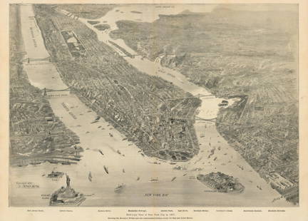
Sold2021New York Bay, 1897Bird’s-Eye View of New York City in 1897This small but intensely detailed map of the city of New York depicts a near snapshot of what could be seen from a rare objective-above. With Burroughs aSee Sold Price
Sold2019Hudson by Daylight MapTitle/Content of Map: Hudson by Daylight Map Date: 1878 © Cartographer: LINK, WILLIAM F. Size: 5.5Height - 99Width Publisher: WM. F. LINK from New York Bay to the head of tide water containing nameSee Sold Price
Sold20211861 Map of GermanyAuthor: Johnson Title: 1861 Map of Germany Medium: Ink on Paper Dimensions: 18"X13.5" Map of Germany dated 1861. Engraved by A.J. Johnson dated 1861. Published by Johnson and Ward in New York. CaptureSee Sold Price
Sold201713 1859 U.S. Coastal Survey MapsDESCRIPTION: Collection of thirteen 1859 United States coastal survey maps from a trigonometrical survey. Includes: St. Mary's River, Maryland; New York Bay and Hudson River; Port Royal Entrance of SoSee Sold Price
Sold2016Map, Hudson River, Rev. War, Sauthier, 1776At the top of the map is written: "A Topographical Map of Hudsons River, with the Channels Depth of Water, Rocks, Shoals, &c. and the Country Adjacent, from Sandy-Hook, New York and Bay to Fort EdwardSee Sold Price
Sold2020Map of New York and New Jersey, 1861Map of New York and New Jersey, 1861, 25.5" x 21.5" in frame, 22.5" x 18" without frameSee Sold Price
Sold2018Lot of 8 Civil War era newspapers with front page MAPSLot of 8 issues (7 of The New York Herald and 1 of N.Y. World), various dates in 1861, 1862 ad 1864, featuring FRONT PAGE MAPS from Civil War battle locations. Oct. 13, 1861: Two maps: Locations at ChSee Sold Price
Sold2022[CIVIL WAR-MAPS] The New York Herald War Maps and Diagrams. New York: Edward Lloyd, n.d., circa[CIVIL WAR-MAPS] The New York Herald War Maps and Diagrams. New York: Edward Lloyd, n.d., circa 1861. An unusual compilation of lithographed maps within a black border, appears to be four sheets joineSee Sold Price
Sold2023Pair of folky golden ploverPair of folky golden plover decoys, in the style of CHIEF EUGENE CUFFEE (Shinnecock, Long Island, New York, 1861-1941), in original paint, having tack eyes and crossed wing tips, the legs partially caSee Sold Price
Sold2020Nautical Map / Sea Chart, #224 Oyster & Huntington BaysUnited States East Coast, New York, Oyster & Huntington Bays, South Shore of Long Island Sound, 3rd edition feb 1/43; revised 7/21/58, note heavier bond paper and or better preserved than most; FoldedSee Sold Price
Sold20241639 Jan Jansson Antique Map of North America Virginia to New York to New EnglandThis beautifully hand coloured, important original antique map of the north east regions of the United States from Virginia, Chesapeake Bay, to New York & New England by Jan Jansson was published in tSee Sold Price
Sold20241755 Map of the Five Great Lakes French Indian WarMap of the Five Great Lakes, part of Pensylvania, New York, Canada, and Hudson's-Bay Territories & c, printed for and contained in "The London Magazine or Gentleman's Monthly Intelligencer for SeptembSee Sold Price
Sold20231778 J. Lodge Exact Map of the Five Great Lakes1778 Lodge Exact Map of the Five Great Lakes with Part of Pensilvania New York, Canada and Hudson's Bay Territories from the best Surveys. Hand colored, fine framed acid free mount example. 8 1/2 by 1See Sold Price
Sold20211778 Lodge Map of the Great Lakes -- An Exact Map ofTitle: 1778 Lodge Map of the Great Lakes -- An Exact Map of the Five Great Lakes with Part of Pensilvania, New York, Canada and Hudson's Bay Territories From the Best Surveys Cartographer: J Lodge YeaSee Sold Price
6 days LeftSwann Auction Galleries(HUDSON RIVER.) William F. Link. The Hudson by Daylight. Map from New York Bay to the Head of TideUS$225
6 days LeftSwann Auction Galleries(COLONIAL NEW YORK.) Major Samuel Holland. The Provinces of New York, and New Jersey; with part ofUS$1,100
6 days LeftSwann Auction Galleries(CIVIL WAR.) [Charles Magnus]. [One Hundred Miles Around Richmond].US$500
Featured5 days LeftJasper52A plan of the operations of the King's army… in New York… FADEN/STEDMAN 1794 mapUS$6,500
6 days LeftSwann Auction Galleries(NEW YORK BAY.) Robert Laurie & James Whittle. Chart of the Entrance of Hudson's River, from SandyUS$1,500
6 days LeftSwann Auction Galleries(NEW JERSEY.) Oakley Hoopes Bailey. Atlantic Highlands, New Jersey.US$750
6 days LeftSwann Auction Galleries(NEW YORK CITY -- BROOKLYN BRIDGE.) Currier & Ives. Grand Birds Eye View of The Great East RiverUS$3,800
6 days LeftSwann Auction Galleries(NEW YORK CITY.) H. Walter; after John Bachmann. Vue General de New-York.US$2,200
6 days LeftSwann Auction Galleries(NEW YORK CITY.) Currier & Ives; with Charles Parsons and Lyman Atwater. The Port of New York,US$3,800
6 days LeftSwann Auction Galleries(AMERICAN REVOLUTION -- NEW YORK CITY.) Major Samuel Holland. The Seat of Action Between the BritishUS$3,800
6 days LeftSwann Auction Galleries(CIVIL WAR.) John Bachmann. Panorama of the Seat of War - Bird's Eye View of Virginia, Maryland,US$600
Featured5 days LeftJasper52NEW YORK CITY antique town city map plan. Manhattan Brooklyn Jersey. SDUK 1844US$550
5 days LeftJasper52An accurate Map of New York, in North America… Universal Magazine 1780 oldUS$550
6 days LeftSwann Auction Galleries(TRI-STATE AREA.) A.R. Ohman Map Co. Map Showing 100 Miles Around New York City.US$450
6 days LeftSwann Auction Galleries(NEW YORK CITY.) G.W. Colton; and J.M. Atwood. Map of the Country Thirty Three Miles Around the CityUS$600


![[CIVIL WAR-MAPS] The New York Herald War Maps and Diagrams. New York: Edward Lloyd, n.d., circa: [CIVIL WAR-MAPS] The New York Herald War Maps and Diagrams. New York: Edward Lloyd, n.d., circa 1861. An unusual compilation of lithographed maps within a black border, appears to be four sheets joine](https://p1.liveauctioneers.com/292/250642/130213465_1_x.jpg?height=310&quality=70&version=1654271664)


![(CIVIL WAR.) [Charles Magnus]. [One Hundred Miles Around Richmond]. (1 of 1)](https://p1.liveauctioneers.com/199/332329/179231616_1_x.jpg?height=282&quality=70&version=1717450360)


