Sold2018North Atlantic Airlines Route Map Information Booklet CNorth Atlantic Airlines Route Map Information Booklet Circa 1950sSee Sold Price
Sold2021FOLK ART PAINTED SHIP DIORAMA W/ TUG BOAT, 19TH C.FOLK ART PAINTED SHIP DIORAMA W/ TUG BOAT, 19TH C., H. 13" L. 24"; US FLAG-BANNER DATED 1894. 1888-1891- FASTEST SHIP ON NORTH ATLANTIC ROUTE. BRITISH BUILT FOR US 1894. UTILIZED IN SPANISH AMERICAN WSee Sold Price
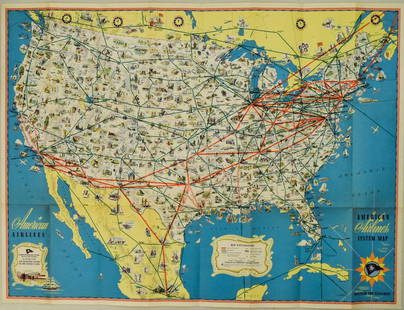
Sold20221940s American Airlines US Route Map -- American Airlines System MapTitle: 1940s American Airlines US Route Map -- American Airlines System Map Cartographer: American Airlines (General Drafting Co.) Year / Place: 1940s c. Map Dimension (in.): 24 X 32 in. Ths is an attSee Sold Price
Sold2020North Atlantic trade routes. Portolano styleTitle: North Atlantic trade routes. Portolano style Date/Period: 1744-1748 Materials: Copperplate engraved Dimensions: 19x16 1/4”. Map by Emanuel Bowen, published by John Harris in 'Navigantium AtquSee Sold Price
Sold2022Vintage Air France Airline Travel Routes World MapVintage Air France Airline Travel Routes World Map, by Lucien Boucher (French, 1889-1971) color offset, C.1948. Framed. Size: 19.5'' x 33.75'', 50 x 86 cm (sight); 24.5'' x 39'', 62 x 99 cm (frame).See Sold Price
2018Pair of 19th c. Railroad Maps, Routes, SchedulesIncluding: ** WEST SHORE ROUTE. NEW YORK, WEST SHORE, & BUFFALO…. March, 1885. On light pink paper, some panels faded, Very Good. ** THE NORTH-WESTERN LINE… DIRECT CONNECTION TO AND FROM ALL POINTSee Sold Price
Sold2018Radefeld: North America with Atlantic Shipping RoutesMap Title: Ueberfahrts-Karte Cartographer: Bibliographischen Instituts. / Radefeld Place & Date: Hildburghausen / 1849/1857 Size: 14 1/8" x 11 3/8" Condition: original outline color; light overall ageSee Sold Price
Sold2021Brockhaus (Pub) 1890's Mixed Lot of 14 Antique MapsIncl Poland, North America, Chicago, Atlantic Ocean Routes, France and Military Locations, Australia, Athens, British North America, Balkans, Bohemia, and Alexandria. Lithograph Maps Published 1892-98See Sold Price
Sold2017Map of Atlantic Ocean Communication, 1885Map: Atlantic Ocean &c. Shewing the Communication Between Europe, North America and the Pacific From Black's General Atlas of the World New and Revised Edition. Edinburgh 1885 Size: 17.25 x 12.25 inchSee Sold Price
Sold2018Bartholomew: Antique Map of Atlantic Ocean, 1879Title/Content of Map: Atlantic Ocean &C. Date Printed: 1879 Cartographer: BARTHOLOMEW, J. Size (inches): 10.5X15 Dry."shewing the communication between Europe, North America and the Pacific." Shows unSee Sold Price
Sold2022White Pass and Yukon Route Handbook [153151]Cute c.1930s tourism booklet, "A Hand Book of Vacation Trips in Alaska and the Yukon on the White Pass and Yukon Route." 55 pp. with maps of routes, black-and-white photographs and descriptions of theSee Sold Price
Sold2023Antique Map - USA - Port of Boston - North Atlantic Ocean - Marco ColtelliniTitle: Antique Map - USA - Port of Boston - North Atlantic Ocean - Marco Coltellini Date/Period: 1763 Dimensions: 24 cm x 31 cm Material: Paper Additional Information: This wonderful engraving " CartaSee Sold Price
Sold2024Pair of American Aviation Official Airline Guides - October 1957 and March 1965A pair of Official Airline Guides North American Edition published by American Aviation with airline schedules, fares and information. October 1957 guide with over 650 pages and fold out map, shows moSee Sold Price
Sold2021Rare California tourist booklet with maps 1930Heading: (California) Author: Title: Motourist Maps: Western States Tourist Information Place Published: South Gate, CA Publisher:Burt Hard & Company Date Published: c.1930 DescriptionSee Sold Price
Sold2023Fly CAT / See Taiwan. Government Information Office, Republ...Fly CAT / See Taiwan. Government Information Office, Republic of China, ca. 1960s. Pictorial airline travel poster map of Taiwan. CAT’s routes and airports are marked with pink lines and red dotSee Sold Price
Sold20241892 Black Map of North America [on Separate Sheet} Atlantic Ocean CurrentsTitle: 1892 Black Map of North America [on Separate Sheet} Atlantic Ocean Currents Cartographer: A&C Black Year / Place: 1892, Edinburgh Map Dimension (in.): 21.3 X 16.6 in. Larger This is a highly deSee Sold Price
Sold2022The Story of The Thirty-Eighth by Lueutenant C. E.Softcover : in Good Condition. Original Stiff Printed tan Cover. Included is 2 maps of the war and 2 newspaper articles consisting of information of the second battle of Marne. 214 Pages.See Sold Price
Sold2020Air France. Flying Holidays this Year! Circa 1935.Air France. Flying Holidays this Year! Circa 1935. Offset lithograph travel poster with the airline’s route map printed within the outline of a propeller plane, covering major cities of Europe aSee Sold Price
Sold20191710 SENEX MAP OF NORTH AND CENTRAL AMERICAc. 1710, Map: “NORTH AMERICA,” & “CENTRAL AMERICA,... Corrected from the Observations Communicated to the Royal Society at London And the Royal Academy at Paris,” by John SenexSee Sold Price
Sold2022De Wit, Map of North and South America, c. 1720Property of a Private Collector, Hilton Head Island, SC Description: Frederick De Wit (circa 1629-1706), Nova Orbis Tabula In Lucem Edita, A.F. De Wit, Amsterdam: Covens and Mortier, c. 1720, publSee Sold Price
Sold2015Munster. TABULA NOVARUM INSULARUM... [c. 1558-59.][Munster, Sebastian] TABULA NOVARUM INSULARUM, QUAS DIVERSIS RESPECTIBUS OCCIDENTALES & INDIANAS UOCANT. Double-page woodcut map of North and South America by Sebastian Munster. First cut in 1540, thiSee Sold Price
Sold2023Seutter - Map of North America including Great Lakes, Florida, Virginia, New England, Mexico, WestThis engraving is from a composite atlas presented by the Homann Heirs. Many of the maps in the collection were completed by J. B. Homann, Homann Erben, M. Seutter, and T. C. Lotter. The maps were oriSee Sold Price
Sold2022Mitchell's large Mexican-American War map, 1847Heading: Author: Mitchell, Samuel Augustus Title: Map of Mexico, Including Yucatan & Upper California, Exhibiting the Chief Cities and Towns, the Principal Travelling Routes &c. Place Published: PhilSee Sold Price
2022Blaeu, Johannes (Netherlands, 1596-1673) "The New World Map" Double Hemisphere World Map C. 1664Nova et Accuratissima Totius Terrarum Orbis Tabula Translated "The New World Map", Hand Colored w/ Elaborately Decorated Spandrels.   Sight View 16" x 21-1/2", Overall View 21" x 25-1/2"See Sold Price
Jun 08Early American History Auctions1853 Map, Basin of the St. Lawrence, by T. Keefer showing Natural + Artificial North American RoutesUS$220
Jun 12Dan Morphy AuctionsBRUE'S MONUMENTAL WALL MAP OF TEXAS, UPPER CALIFORNIA & MEXICO, C. 1845US$500
7 days LeftCedarburg Auction & Appraisals LLCSet of Four Maps Showing All of Spain and PortugalUS$375(2 bids)
May 31Block Auction HouseGeorge Nelson & Associates (American, 1908-1986) OMNI Four-Bay Wall Unit, c. 1956US$500


![White Pass and Yukon Route Handbook [153151]: Cute c.1930s tourism booklet, "A Hand Book of Vacation Trips in Alaska and the Yukon on the White Pass and Yukon Route." 55 pp. with maps of routes, black-and-white photographs and descriptions of the](https://p1.liveauctioneers.com/2699/258191/134291067_1_x.jpg?height=310&quality=70&version=1660870939)


![Munster. TABULA NOVARUM INSULARUM... [c. 1558-59.]: [Munster, Sebastian] TABULA NOVARUM INSULARUM, QUAS DIVERSIS RESPECTIBUS OCCIDENTALES & INDIANAS UOCANT. Double-page woodcut map of North and South America by Sebastian Munster. First cut in 1540, thi](https://p1.liveauctioneers.com/179/82189/42599755_1_x.jpg?height=310&quality=70&version=1447864785)


