Sold20201901 English Seamen Slave Trade in the 16th Century1901 FROUDE English Seamen in the 16th Century. Chapters on Sir Francis Drake and Hawkins, the expedition to the West Indies and the Spanish Armada. J.A. FROUDE. English Seamen in the sixteenth centurSee Sold Price
Sold20241844 LIFE VOYAGES & EXPLOITS of SIR FRANCIS DRAKE by JOHN BARROW antique1844 LIFE VOYAGES & EXPLOITS of SIR FRANCIS DRAKE by JOHN BARROW London; 1844 Bound with: High-ways & Dry-ways or, the BRITTANIA AND CONWAY TUBULAR BRIDGES London; 1849 Original publishing cloth withSee Sold Price
Sold20221646 Voyages West Indies South America Map PlatesHistorisch journael vande voyage ghedaen met ses schepen, uytghereed zijnde door de . Oost-Indische Compaignie . omme te varen door de Strate Magallanes naer de Molucques . Onder 't gebiedt van . JoriSee Sold Price
Sold2023(6) Royal Doulton Toby Jugs Falstaff Huntsman & More"Great variety of Royal Doulton Toby Jugs that include Falstaff The Huntsman Jolly Toby Sir Francis Drake Sherlock Holmes Happy John. All approx 6"" to 9"" tall"See Sold Price
Sold2024Sir Francis Drake Large D6660 - Royal Doulton Toby JugDimensions: 6.5"L x 4"W x 9"H Manufacturer: Royal Doulton Country of Origin: EnglandSee Sold Price
Sold2024Francis McNally - Antique Map of West IndiesThis is a fine example of McNally's System of Geography by: Francis McNally, published by A.S. Barmes & Co. in 1875. This atlas was made for schools, academies, and seminaries to teach students aboutSee Sold Price
Sold2017Jefferys: Antique Map of the West Indies, 1762Map: West Indies. Cartouche of European Traders & Slave at Work Publication Date: 1762 Authors: JEFFERYS, T. Size: Octavo – 6.80 H x 11.50 W Inches Cartouche. From Kitchin's The modern geography. PlSee Sold Price
Sold2021Royal Doulton Character Toby Pitchers / JugsLot of six Royal Doulton Toby Pitchers measuring from 6.25" to 9" tall. Includes: "Jolly Toby," "Sir John Falstaff," "Sherlock Holmes" D6661, "Happy John", "Sir Francis Drake" D6660, and "The HunstmanSee Sold Price
Sold2019West Indies from The Best Authorities.Title/Content of Map: West Indies from The Best Authorities. Date: c1790 Cartographer: LODGE, JOHN Publisher: POLITICAL MAGAZINE Size: 6.75Height - 11.75Width A general regional map with a few place nSee Sold Price
Sold2023PORT OF SPAIN. Vintage map. Trinidad. West Indies. Caribbean 1927 oldPart of Port of Spain, Trinidad' by Sifton, Praed & Co. Ltd, St. James's St. London S.W. (1927). Vintage map, 17.5 x 14.5cm, 6.75 x 5.5 inches; Please note that this is a folding map. TITLE/CONTENT OFSee Sold Price
Sold20201828 Leather Set Columbus Voyages MapsHistoire De La Vie Et Des Voyages De Christophe Colomb, by Washington Irving, printed at Paris by Charles Gosselin. Four volume set including the two large folding tinted maps of the West Indies. TreeSee Sold Price
Sold20191866 McNally's Map of the Caribbean -- West IndiesTitle/Content of Map: 1866 McNally's Map of the Caribbean -- West Indies Date: 1866 New York Cartographer: F McNally Size: 8.3 X 10.6 in. This is a charming map of the West Indies, with an elevation cSee Sold Price
Sold20201857 Colton Map of the Caribbean / West Indies -- WestTitle/Content of Map: 1857 Colton Map of the Caribbean / West Indies -- West Indies Cartographer: J Colton Year/Place: 1857, New York Size: 11.6 X 14.6 in. This is a very nice engraved map of the CariSee Sold Price
Sold2017Map Showing the 4 Voyages of Christopher ColumbusMap: Chart of the West Indies With the Adjacent Coast of South America, Showing The Tracks Of Don Christopher Columbus Size: Folio – 11.00 H x 15.90 W Inches Publisher: George P. Putnam 1849 New YorSee Sold Price
Sold2016[HAWAII & ALASKA RELATED] MISC. LOT OF PRINTScontaining various engravings from Cook's voyage and other 18th Century engravings of Hawaii and the West Indies, including several early maps of Hawaii, as well as views of Alaska and other NorthwestSee Sold Price
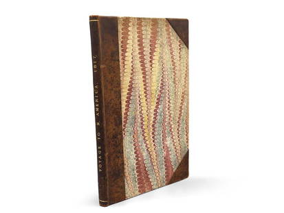
Sold2023Montule: Voyage to North America"A Voyage to North America, and the West Indies in 1817", E. Montule. First edition. London. Printed for Sir Richard Phillips and Co. 1821. 9-1/2in tall x 6in wide. | Philadelphia Metro area delivery,See Sold Price
Sold2021Mexico, Guatimala and West Indies.Title: Mexico, Guatimala and West Indies. Cartographer: BOYNTON, G. W. Publisher: S.G. GOODRICH Height: 3.25 Width: 6 Miniature school geography map. Original coloring. Reserve: $75.00 Shipping:See Sold Price
Sold2018West IndiesReserve Reduced! Title/Content of Map: West IndiesDate: 1835 Cartographer: Bradford, T.G. Material/Medium: William D. Ticknor Size: 7.6 x 9.75 inches Map showing countries separately outline colored.See Sold Price
Sold2022WEST INDIES. 1600-1660. Caribbean, Colonial Era, sketch map 1942 oldTITLE/CONTENT OF MAP: 'The Caribbean in the Colonial Era' DATE PRINTED: 1942 IMAGE SIZE: Approx 11.5 x 15.5cm, 4.5 x 6 inches (Small) TYPE: Vintage map. This map was published in 1942 but it may depicSee Sold Price
Sold2020Bartholomew, John 1922 Lot of 6 Maps of the AmericasIncl Mexico, West Indies, South America Political, South America North, South America South, and Argentina/Chile. Large Lithograph Maps Published 1922 by The Times, London for "The Times Survey AtlasSee Sold Price
Sold2018Captain McClintock THE VOYAGE OF THE FOX IN THE ARCTICCaptain McClintock THE VOYAGE OF THE FOX IN THE ARCTIC SEAS A NARRATIVE OF THE DISCOVERY OF THE FATE OF SIR JOHN FRANKLIN AND HIS COMPANIONS 1860 Double-Sided Folding Map Engraved Francis McClintock ISee Sold Price
2022Drake Hatless D6115, Green - Large - Royal Doulton Character JugRare. Style One, without hat. Variation no. 2. White ruff, green collar. Raised lettering, Sir Francis Drake, on back of coat. Royal Doulton backstamp. #royaldoulton #characterjug #sirfrancisdrake #coSee Sold Price
Sold2022Drake Hatless D6115, Green - Large - Royal Doulton Character JugRare. Style One, without hat. Variation no. 2. White ruff, green collar. Raised lettering, Sir Francis Drake, on back of coat.See Sold Price
Sold201517th/18th C. Old Master painting,explorer Sir. F. Drake17th/18th century Old Master painting. Depicting Sir Francis Drake. Oil on Canvas. Inscription upper right- "Columbus NE A GENOA AN 1447" . Housed in an ornate carved 18th century frame. Painting haviSee Sold Price
5 days LeftSwann Auction Galleries(ARCTIC.) Sir John Ross. Narrative of a Second Voyage in Search of a North-West Passage, and of aUS$450
Featured4 days LeftJasper52West Indies. Haiti/Dominican Republic borders differ. BARTHOLOMEW 1886 old mapUS$10
4 days LeftJasper52WEST INDIES. West Indies in Dioceses; USA Bishoprics Church of England 1922 mapUS$10
Featured4 days LeftJasper52Carte de l'Isle de la Grenade'. Grenada. West Indies. BELLIN 1759 old mapUS$70
4 days LeftJasper52West Indies and Central America; Inset British Guiana. Caribbean 1898 old mapUS$15
4 days LeftJasper52HAWAII HISPANIOLA. Hawaiian Isles; Haiti San Domingo Dominican Republic 1898 mapUS$20


![[HAWAII & ALASKA RELATED] MISC. LOT OF PRINTS: containing various engravings from Cook's voyage and other 18th Century engravings of Hawaii and the West Indies, including several early maps of Hawaii, as well as views of Alaska and other Northwest](https://p1.liveauctioneers.com/522/94826/48360052_1_x.jpg?height=310&quality=70&version=1476195147)