Sold2020Hubert Jaillot Map South America 1719Hubert Jaillot (1632-1712), "Amerique Meridionale divisee en ses pricipales Parties ou sont distingues les uns des autres les Estats suivant qu'ils appartiennent presentement aux Francois, Castillans,See Sold Price
Sold2023Jaillot Map of South America with Exceptional ColorJAILLOT, Alexis Hubert (1632-1712). L'Amerique Meridionale. Engraved map with exceptional original color. Paris, c. 1691. 24 3/4" x 36 1/4" sheet. Large format map of South America, based upon earlierSee Sold Price
Sold2017Jaillot Map of South America, 1690Title: 1690 Jaillot Map of South America Cartographer: AH Jaillot Published: 1690 c. Paris Measurements: 22 x 35 in. Amerique Meridionale divisee en ses Principales Parties ou sont distingues les unsSee Sold Price
Sold2022South America.- Jaillot (Alexis-Hubert) Amerique Meridionale Divisee en ses Principales Parties ouSouth America.- Jaillot (Alexis-Hubert) Amerique Meridionale Divisee en ses Principales Parties ou sont Distingues les uns des Autres les Estats Suivant Quils Appartiennent Presentement aux Francois,See Sold Price
Sold2023ANTIQUE COPPER ENGRAVING MAP SOUTH AMERICAAntique copper engraving hand colored map of South America by Jaillot, published by Ottens. Impressive large map of South America with fair amount of detail of rivers, mountains and settlements. ReasoSee Sold Price
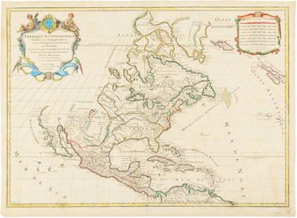
Sold2016Hubert Jaillot. Amerique Septentrionale diviséeHubert Jaillot. Amerique Septentrionale divisée en ses principales parties<See Sold Price
Sold2015Map of North America 1719Heading: (North America) Author: Sanson, Nicolas/ Hubert Jaillot Title: Amerique Septentrionale divisée en ses Principales Parties, ou sont distingués les uns des autres les Estats suivant quils appSee Sold Price
Sold2017Chatelain: Carte Paraguai Chili Detroit Magellan, 1719Map: Carte du Paraguai, du Chili, du Detroit de Magellan Cartographer: Chatelain Place & Date: Amsterdam / 1719 Size: 20 1/4" x 15 3/4" Chatelain's superbly detailed map of southern South America exteSee Sold Price
Sold2020John Senex Map of North and South America 1719-17John Senex (1678–1740), "A New Map of America from the Latest Observations," London, ca. 1719-1721. Hand colored copperplate engraved map of North and South America, from Senex's "New General ASee Sold Price
Sold20241719 Map of Colonial era North America, by Sanson - JaillotTitle: 1719 Map of Colonial era North America, by Sanson - Jaillot Date/Period: 1719 Materials: Copperplate engraved Size: 25 1/2 x 18” This map is a rare and valuable map of history, showing NoSee Sold Price
Sold2022Antique 16th Century Map South AmericaTitle: Antique 16th Century Map South America Description:Antique 16th Century Map South America Circa Date: 1598 Condition of piece: Map displays toning, some water stains, wrinkles and creases,See Sold Price
Sold2022MAP, South America, WitNorthwestern South America & Central America. Frederick de Wit, Novae Hispaniae, Chili, Peruviae, et Guatimalae Littorae, from Orbis Maritimus ofte Zee Atlas, 1680 (circa). Hand Color. This handsome sSee Sold Price
Sold2018Antique map, south America, Peruvia id est, Novi OrbisAntique map, south America, Peruvia id est, Novi Orbis pars Meridionalis a Praestantissima eius in Occidentem Regione sic Appellata. 1598, engraved in Cologne by Johann Bussemacher, framed, map size iSee Sold Price
Sold2018Antique map, south America, 1598, Johann BussemacherAntique map, south America, Peruvia id est, Novi Orbis pars Meridionalis a Praestantissima eius in Occidentem Regione sic Appellata. 1598, engraved in Cologne by Johann Bussemacher, framed, map size iSee Sold Price
Sold2022MAP, South America, SeutterSouth America. Seutter/Lotter, America Meridionalis, per sua Regna Provinc: et Ins: Juxta Observation: et Descript Recentis: Divisa et Adornata Cura et Opera, from Atlas Minor, 1744 (circa). Hand ColoSee Sold Price
Sold2023Antique French Engraving Felix Delamarche map South America 1838Charles-Francois Delamarche (1740-1817), the founder of the family firm was one of the most important French geographers and mapmakers of the second half of the eighteenth century. Successor to NicolaSee Sold Price
Sold20191694 HUBERT JAILLOT MAP OF ITALY1694 Hubert Jaillot Publishers Paris - Topographic Map of Italy. 19" x 23.50". Laid on silk. As found condition.See Sold Price
Sold20231950s PanAm Route Map of South America's East Coast -- Pan American Flight Map, South America EastTitle: 1950s PanAm Route Map of South America's East Coast -- Pan American Flight Map, South America East Coast Cartographer: PanAm Year / Place: late 1950s c. Map Dimension (in.): 23.5 X 16.8 in. folSee Sold Price
Sold20201787 Folding Map South America KitchinLarge folding map "South America Drawn from the latest and Best Authorities" incuding the Galapagos Islands by Thomas Kitchin and engraved by Terry. Published for John Harrison, 1787. Fine, a few smalSee Sold Price
Sold2021Thomas Bowen Map, South America"An Accurate Map of South America", hand colored engraving, Bankess, London. Toning, taped tear at the top left. Sight 13"h x 18.25"w, frame 17"h x 21.5"wSee Sold Price
Sold2024Antique Map - South America - D.Veremondo Rossi - Brazil - Argentina - PeruThis wonderful engraving " Carta rappresentante l'America Meridionale" (Map representing South America.) originates from "ll Gazzettiere americano contenente un distinto ragguaglio di tutte le paSee Sold Price
Sold2024Antique Map - South America - Chart of Strait of Magellan - Patagonia - ChileThis large, original copper engraved, antique map, a chart of the Straits of Magellan, South America and the Patagonian & South Chilean shoreline was engraved by Robert Benard and published in theSee Sold Price
Sold202317th- 18th C Maps, South America West Indies (5pc)Five Small 17th-18th C. Maps: (1) Map titled "DESCRIPTION DE IUCATANE", good condition, measures: 4.5" H x 7.25" W, (1) Map titled "VILLE DE PISCO", good condition, measures: 5.75" H x 8.5" W. (1) MapSee Sold Price
Sold20222 ANTIQUE MAPS SOUTH AMERICA1- 1830 Huntington Map South America Brazil Bolivia Peru Argentina Colombia Chile 11"x8 3/4". 2- Carte de la Partie Meridionale du Bresil c. 1780. 15"x9 3/4".See Sold Price
21 mins LeftJasper52South America. Commercial/Industrial Development. Agricultural products 1925 mapUS$8
21 mins LeftJasper52SOUTH AMERICA NW. Shows Colombian & Peruvian claims on Ecuador. Lima 1898 mapUS$8
Featured21 mins LeftJasper52SOUTH AMERICA. Bolivia includes Acre, now in Brazil. JOHNSTON 1900 old mapUS$10
21 mins LeftJasper52AMAZONIA & ANDEAN STATES. Colombia includes Panama. Venezuela. LETTS 1884 mapUS$20
21 mins LeftJasper52BRAZIL & THE GUIANAS. Inset Rio de Janeiro & Salvador de Bahia plans 1912 mapUS$8
21 mins LeftJasper52SOUTH AMERICA NW. Venezuela Colombia Ecuador Peru Bolivia. Inset Lima 1912 mapUS$8
21 mins LeftJasper52S AMERICA. Patagonia La Plata.Bolivia with Litoral.New Granada/Colombia 1882 mapUS$8
21 mins LeftJasper52SOUTH AMERICA NORTHERN.Brazil Peru Ecuador Colombia Venezuela.JOHNSTON 1906 mapUS$8
21 mins LeftJasper52SOUTH AMERICA. Brazil & the Guianas. Inset Rio de Janeiro. BARTHOLOMEW 1890 mapUS$8
21 mins LeftJasper52BRAZIL & THE GUIANAS.Dutch French British Guiana(Guyana).Rio de Janeiro 1901 mapUS$8
21 mins LeftJasper52SOUTH AMERICA NW. Venezuela Colombia Ecuador Peru Bolivia. Inset Lima 1901 mapUS$8
21 mins LeftJasper52SOUTH AMERICA. With United States of Colombia(Colombia & Panama).BUTLER 1888 mapUS$8
21 mins LeftJasper52ARGENTINA CHILE URUGUAY. Inset Lima Valparaiso Buenos Aires Montevideo 1909 mapUS$8
21 mins LeftJasper52SOUTH AMERICA. South. Argentina Chile Uruguay 1962 old vintage map plan chartUS$8