Sold2016The Adjustment Bureau Map Book Movie PropsScreen used, brown leather bound Map Book with multiples map pages inside. (approx. 9 1/4" x 6 1/4")See Sold Price
Sold2022China: Her Life and Her PeopleFIRST EDITION. Pictorial dust-jacket with title. Publishers buff cloth with red title. Map endpapers. Full-page plates and in-text illustrations. Full-page maps. This book is written for those who desSee Sold Price
Sold2023A Fly Fishermen's Guide to Fishing the Croton Watershed Book64-page softcover book with maps and illustrations. A guide to the streams and reservoirs of the Croton Watershed including maps of all the rivers, where the good holes and runs are, techniques and flSee Sold Price
Sold2021Collection of Promenade Hill Hudson,NY Photos & MoreCollection of 16 Historic Hudson NY and Columbia County Photographs, plus newspaper clippings, postcards, pages from books, and a map of Columbia County. Included are Promenade Hill, the Hudson-AthensSee Sold Price
Sold2021MAP OF PALESTINE & Jerusalem, Modern & Biblical NamesAntique color atlas map entitled A MAP OF PALESTINE - Double Page Book Plate with inset map of the city of Jerusalem in upper left corner | With modern and Biblical names | Published c. 1881 | Approx.See Sold Price
Sold2022History of the 90th Division : First Edition 1920Hardcover : in Good Condition. Good solid book with maps included. 257 Pages.See Sold Price
Sold2023(NORTH AMERICA.) Henricus Hondius. America Septentrionalis.(NORTH AMERICA.) Henricus Hondius. America Septentrionalis. Double-page engraved map of North America with California as an island and attractive carto-ornamentation. 19¼x23½ inches sheet siSee Sold Price
Sold2021Three Title - Sea-faring BooksBook I. 'H.M.S. Fidelity' 1957. Full-page illustrations. Book II. 'Kicking Canvas' 1957. Pictorial dust-jacket. [some wear] Name on inside. Map endpapers. Full-page illustrations. Book IISee Sold Price
Sold2021Butte 1916 Original Sanborn Insurance Map Book [139806]24" x 26" x 4." Ledger book, spine is missing, front board is loose. has 1953 additional index. 119 pages including 1942 update in the back. These books are an incredible important reference for any hSee Sold Price
Sold20181911 Philadelphia 24 34 44 Wards Atlas Map BookFirst few pages have wear, tear , and a couple are loose.See Sold Price
Sold20211973 Large De Kalb County IL Aerial Map Book1973 Large De Kalb County IL Aerial Map Book by Sidwell. Measurements in inches: 21 x 31 Condition:Pages have some toning Shipping:We offer in-house shipping. Item(s) will be packed after invoice is pSee Sold Price
Sold2016Large collection of over 75 book mapsLarge collection of over 75 book maps. Maps mostly from Rand McNally book. Pages not attached; no book cover; stains; foxing; tears. Largest measures 19 inches x 12 1/2 inches.See Sold Price
Sold202018th C. Engraved / Colored Map of Central AmericaNorthern Europe, United Kingdom or colonies, ca. 18th to early 19th century CE. An engraved page from a book showing a color map of "Mexico or New Spain" clearly labeled in English. "The Pacific or SoSee Sold Price
Sold2020Grp: 6 Maps of Europe by Braun & HogenbergGroup of six maps by Georg Braun (1541–1622) and Frans Hogenberg (1540–1590) including maps of Ghent, Odense in Denmark originally for the book "Civitates Orbis Terrarum", a map of ParisSee Sold Price
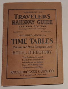
Sold20241915 Traveler's Guide Eastern US. A 344 page bookA 5 3/4" by 8" soft cover book with railroad timetables and other travel information: hotel ads, city, state maps, etc. Paper is supple and not pulpy.See Sold Price
Sold2024MAPS IN BOOKS, Atlases, Buy de MornasContains 135 Double-Page Maps in Contemporary Color. Atlases. Claude Buy de Mornas, [4 Volumes] Atlas Methodique et Elementaire de Geographie et d'Histoire, 1761-62 (published). Hand Color. A large anSee Sold Price
Sold2022The Nations At War By Willis J. AbbotIllustrated with many Plates in Full Color, Photograhps, Maps, Charts, and Diagrams. 366 pages. The book is in fair condition. Cover edge wear and a couple loose pages. The spine needs to be reglued.See Sold Price
Sold2023George Catlin Indian Gallery [170312]This is a publication put out by the U.S. National Museum and authored by Thomas Donaldson. This 939 page book has an 1887 copyright. There are also several loose maps, showing the various tribal landSee Sold Price
Sold2018Signposts of Adventure by James Willard SchultzSignposts of Adventure by James Williard Schultz. 1926, first edition. Dust jacket G/Vg. Book interior pages Ex/Ex+, covers and spine Ex. 225 pp. + folded map of Glacier National Park with Key to IndiSee Sold Price
Sold20231888 Hand Book of the Pennsylvania Lines Containing Maps of Principal Cities - First EditionA first edition Hand-Book of the Pennsylvania Lines by L.G. McPherson, of the Passenger Department, Pennsylvania Lines West of Pittsburgh dated July 1888. The 81 page book is from the Pennsylvania RaiSee Sold Price
Sold2021Background to DiscoveryPacific Exploration from Dampier to Cook' First Edition. Edited by Derek Howse, Pictorial dust-jacket with protective mylar cover. Full-page and in-text illustrations/maps. This book recounts the greaSee Sold Price
Sold2020JANSSONIUS, JOHANNES; after HONDIUS, JODOCUS. AmericaJANSSONIUS, JOHANNES; after HONDIUS, JODOCUS. America Noviter Delineata. Double-page engraved map of the Americas. 19½x22½ inches sheet size, wide margins, Latin text on verso; original handSee Sold Price
Sold2016Cody, W.F. Buffalo Bill’s Wild West Season 1899 RouteCody, W.F. Buffalo Bill’s Wild West Season 1899 Route Book.?A 67-page book detailing the entire staff of the Buffalo Wild West show, in addition to the 1899 route. A foldout map of the United StatesSee Sold Price
Sold2024Santa Fe RR Summer in Southern California Book-1895This is a Santa Fe Railroad book titled Summer in Southern California, dated 1895. This 55 page book is in excellent original condition, with a colored cover, as well as a route map inside the back coSee Sold Price
Jul 16BADO e MART AUCTIONSComposite Atlas. 63 Geographical maps on double pages, engraved in copper on laid paper.€15,000
1 day LeftRapid Estate Liquidators and Auction GalleryAntique Revolutionary War Hardcovers By William James 2 VolumesUS$2,000
1 day LeftRapid Estate Liquidators and Auction Gallery1982 Knoxville World's Fair Information And Maps LotUS$35
1 day LeftJasper52The Consolidated Slave Act of Jamaica 1792. 40 pages. Bryan Edwards 1794 printUS$120
2 days LeftA.H. Wilkens Auctions & AppraisalsPOPE. THE ODYSSEY OF HOMER, FIRST POCKET EDITIONCA$700(1 bid)
4 days LeftTrillium Antique Prints & Rare BooksFirst Printing of the US Constitution in an American Magazine, 1787 (from Columbian Magazine)US$100
2 days LeftRail & Road AuctionsSix Union Pacific Railroad Items - Wall Lamp, China Plates, Travel Guide, Menu, and FramedUS$30
Jul 14Schilb Antiquarian Rare Books1939 John Ogilby Britannia Atlas MAPS 1ed 1675 facsim England Wales COLOR RoadUS$1
2 days LeftDutch Auction SalesRare Book Sir Walter Raleigh History of the World 1614 1st EditionUS$500(1 bid)
2 days LeftNY Elizabeth 1709 SEPTUAGINT GREEK BIBLE ILLUSTRATED WITH MAPS, VINTAGE VELLUM BOUND VERSIONUS$100(1 bid)
Featured8 hrs LeftJasper521719 BIBLE DUTCH BIBLIA FOLIO w/ CLASPS & MAPS antique decorative bindingUS$800
2 days LeftNY Elizabeth FIRST US EDITION OF 1869 MALAY ARCHIPELAGO BY A.WALLACE, ANTIQUE ILLUSTRATED WITH MAPSUS$100


![Three Title - Sea-faring Books: Book I. 'H.M.S. Fidelity' 1957. Full-page illustrations. Book II. 'Kicking Canvas' 1957. Pictorial dust-jacket. [some wear] Name on inside. Map endpapers. Full-page illustrations. Book II](https://p1.liveauctioneers.com/5584/208373/106103962_1_x.jpg?height=310&quality=70&version=1624395684)
![Butte 1916 Original Sanborn Insurance Map Book [139806]: 24" x 26" x 4." Ledger book, spine is missing, front board is loose. has 1953 additional index. 119 pages including 1942 update in the back. These books are an incredible important reference for any h](https://p1.liveauctioneers.com/2699/228546/118157180_1_x.jpg?height=310&quality=70&version=1639011577)


![MAPS IN BOOKS, Atlases, Buy de Mornas: Contains 135 Double-Page Maps in Contemporary Color. Atlases. Claude Buy de Mornas, [4 Volumes] Atlas Methodique et Elementaire de Geographie et d'Histoire, 1761-62 (published). Hand Color. A large an](https://p1.liveauctioneers.com/6576/320593/172252664_1_x.jpg?height=310&quality=70&version=1708729193)

![George Catlin Indian Gallery [170312]: This is a publication put out by the U.S. National Museum and authored by Thomas Donaldson. This 939 page book has an 1887 copyright. There are also several loose maps, showing the various tribal land](https://p1.liveauctioneers.com/2699/299063/159201542_1_x.jpg?height=310&quality=70&version=1692045182)


