Sold2020Scarce 1883 map of TexasExtremely scarce early 1883 map is different from the more common later 1883 and 1884 version of Cram’s Texas. The later versions have green county borders with rose hachures for the state outline.See Sold Price
Sold2021Very scarce Southern Texas, Cram 1882Scarce double-page hand-colored map of Southern Texas from the very early and scarce 1882 Cram’s Unrivaled Family Atlas of the World. All Cram atlases prior to 1883 are extremely scarce. They arSee Sold Price
Sold2021Very scarce Indian Territory/Texas, Cram 1882Scarce two-page, hand-colored map of Indian Territory and Northern Texas from the very early and scarce 1882 Cram’s Unrivaled Family Atlas of the World. All Cram atlases prior to 1883 are extremSee Sold Price
Sold2021Scarce variant of Texas, George F. Cram 1883Title: Scarce variant of Texas, George F. Cram 1883 Description: Cerographic relief line engraving with county divisions in yellow and state boundaries outlined in rose. This double-page map is extremSee Sold Price
Sold2017Scarce Map of Texas, New Mexico and ArizonaItem: Scarce Map of Texas, New Mexico and Arizona Description: Scarce Map of Texas, New Mexico and Arizona from Wallings's 1868 State Atlas of Ohio Dimensions: 14.25 x 26.25 Please note that this lotSee Sold Price
Sold2020Scarce Cowperthwait, Desilver, Butler map of TexasScarce map of Texas by J.H. Young. “Map of the State of Texas from the Latest Authorities by J. H. Young.” 1850 map from an early 1855 edition of the Cowperthwait, Desilver & Butler New UniverSee Sold Price
Sold2020Scarce hand-colored map of Texas, 1875Attractive and scarce map of Texas with inset map "Western Part of Texas". Exquisite detail with counties painstakingly colored by hand. Interesting map of the growing state developed circa 1875 durinSee Sold Price
Sold2019Large & Scarce Bus. Map of Texas, 1892Impressive and highly detailed full color lithographed map from what is considered the best large format American atlas of the latter nineteenth century. Rand McNally’s 1892 Indexed Atlas of the WorSee Sold Price
Sold2022Scarce Texas map (eastern part) from Asher & Adams,County map of Eastern Texas extends from Louisiana west to beyond San Antonio and features the railroad system of that time. Features numerous railroads still in their infancy, along with proposed futSee Sold Price
Sold2022Scarce Texas map (western part) from Asher & AdamsLarge double-page map of Western Portion of Texas with inset of extreme western tip of the state. Shows towns, proposed railroad lines and river, including the Colorado River and the Rio Grande. The fSee Sold Price
Sold2022Clean 1883 RR map of Texas, Geo. F. CramInteresting cerographic map of Texas from Cram’s Unrivaled Family Atlas of the World. Predates subdivision of Tom Green, Pecos, Crockett and Presidio Counties. Shows rail system throughout statSee Sold Price
Sold2019Scarce Colton 1855 map of Texas, Johnson/BrowningScarce large map of Texas with 1855 date, but with Johnson & Browning imprint. The Johnson & Browning imprint was found in only the 1859 Colton atlas and 1860 and 1861 Johnson Family atlases. This mapSee Sold Price
Sold2023Scarce 1845 Mitchell map of Texas with Tanner bordersExtremely scarce 1845 C. S. Williams map of the Republic of Texas from a true first edition of Mitchell's 1846 New Universal Atlas, showing the Carey & Hart decorative borders, which are not found inSee Sold Price
Sold2020Scarce German map of independent Texas 1843Heading: (Texas) Author: Flemming, Carl Title: Texas Place Published: Glogau Publisher: Date Published: 1843 Description: Lithographed map, hand-colored in outline. 39.5x32 cm. (See Sold Price
Sold2021Scarce Colton 2-page map of Texas, c1884Breathtakingly large, fully hand-colored vintage map of Texas from the very scarce 1890 edition of Colton’s General Atlas. This is the only edition of this atlas that I’ve ever seen—See Sold Price
Sold2018Scarce 1875 hand-colored map of Texas by HardestyReserve Reduced! Attractive map of Texas and Indian Territory, colored by counties, from the very scarce Jones & Hamilton Historical Illustrated Atlas of the World published 1875 by H. H. Hardest. NicSee Sold Price
Sold2021Scarce 1853 Texas map by Roswell SmithAntique and hard to find antebellum map with full original hand coloring. Engraving on paper. Shows forts, rivers, locations of tribes, towns, counties and topographical features. Eastern Indian TerriSee Sold Price
2022Scarce 1833 Finley map of Mexico – fine exampleExtremely scarce map of Mexico depicting Texas territory just three years before it gained its independence. Shows major portion of western America still belonging to Mexico, including New Albion andSee Sold Price
Sold2023Scarce 1833 Finley map of Mexico – fine exampleExtremely scarce map of Mexico depicting Texas territory just three years before it gained its independence. Shows major portion of western America still belonging to Mexico, including New Albion andSee Sold Price
Sold2017Rand McNally: Map of Texas from Jones & Hamilton AtlasEarly Rand McNally vertical format Texas map from scarce 1876 Jones & Hamilton atlas. Large and uncommon McNally vertical format map of Texas from the scarce 1876 Jones & Hamilton Historical Atlas ofSee Sold Price
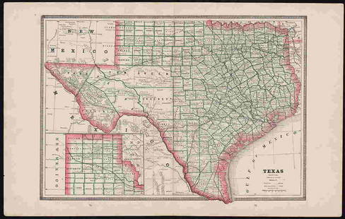
2017George Cram: Map of Texas, 1883Map: Texas Cartographer: George F. Cram Publisher: George F. Cram Co. Published: Chicago, 1883 Size: 11.75 x 17 inches Wonderful authentic antique map of Texas published in 1883 by George F. Cram. PriSee Sold Price
Sold2022Scarce 1844 U. S. map w/large Texas, western territoriesOne of the more interesting and elusive school maps of the United States at a time of great territorial expansion. This 1844 double-page Olney school geography map shows the Republic of Texas in one oSee Sold Price
Sold2022Scarce 1st ed. Northern Texas/Indian Territory, Tunison 1885Beautiful and scarce double-page chromolithographic map of Northern Texas and Indian Territory. From the 1885 edition of Tunison’s Peerless Universal Atlas of the World. WorldCat lists this atlaSee Sold Price
Sold2017Texas nach den Besten Quellen Map, 19th CMap: Texas nach den Besten Quellen Cartographer: Bibliographischen Instituts. / Radefeld Place & Date: Hildburghausen / 1849/1857 Size: 13 7/8" x 11 1/2" Condition: original outline color The scarce sSee Sold Price
4 days LeftJasper52SOUTHERN MEXICO & CENTRAL AMERICA. Lighthouses. Key West Yucatan. LETTS 1883 mapUS$15
3 days LeftJasper521723 Dampier Map of Voyages to Brazil, Australia and Eat Indies -- Voyage du Cap. Dampier a la N.US$280
Jun 23Schilb Antiquarian Rare Books1848 Emory Military Reconnaissance 1ed California MAP Indians Texas New MexicoUS$2(2 bids)
6 days LeftRichmond AuctionsScarce Drink Texas Punch Embossed SST Sign w/ Bottle Reading PAUS$650(2 bids)
Jun 12Dan Morphy AuctionsBRUE'S MONUMENTAL WALL MAP OF TEXAS, UPPER CALIFORNIA & MEXICO, C. 1845US$500
Jun 08Simpson Galleries, LLC.JULIUS BIEN (1826-1909) AN AMERICAN CIVIL WAR RECONNAISSANCE MAP, "Map of Texas and Part of NewUS$100
Jun 06Akiba GalleriesAntique Mast, Crowell, & Kirkpatrick Map Of Texas, California, & NevadaUS$25(1 bid)
Featured3 days LeftJasper521867 Beers Map of New York City Area -- Map of New York and Vicinity Accompanying "Atlas of New YorkUS$200
5 days LeftAntiques Online AuctionsVintage Texas 1845 Map Printed in 1986, Compiled by John DavisUS$60(4 bids)
7 days LeftRichmond Auctions1940 Indian Gasoline Curved SSP Pump Plate Sign w/ The Texas Co AttachmentUS$25(1 bid)
Jun 06Freeman's | HindmanSTEVENSON, Robert Louis (1850-1894). Treasure Island. London, Paris & New York: Cassell & Company,US$1,500
Jun 12Dan Morphy AuctionsGEOLOGY OF THE BLACK AND GRAND RAPIDS OF TEXAS INCLUDING THE EASTERN AND WESTERN CROSS TIMBERS,US$100