Sold2020Bowles, Carrington 1782 Road Map. Devon, CornwallShowing Dorchester, Axminster, Bridport, Falmouth, Truro etc. Copper Engraved Map Published 1782, London for "Bowles's Post-chaise Companion, Or, Travellers Directory Through England and Wales" by CarSee Sold Price
Sold2018UK Road Maps C1750-1785 Lot of 16. Paterson, BowenGood Lot of 16 Copper Engraved Road Maps. 15 by Paterson, Published 1785 by Carrington Bowles, London for "Paterson's British Itinerary" First Edition by Captain Daniel Paterson. Together with one hanSee Sold Price
Sold20231892 Adams and Bowles New Road Map of the State of New YorkThis is a large, wall-hanging 1892 Adams and Bowles New Road Map of the State of New York. It also highlights railroad lines in the state. Paper on linen, with both top and bottom dowels present. FineSee Sold Price
Sold20241892 Adams and Bowles New Road Map of the State of New YorkThis is a large, wall-hanging 1892 Adams and Bowles New Road Map of the State of New York. It also highlights railroad lines in the state. Paper on linen, with both top and bottom dowels present. FineSee Sold Price
Sold2019Philip, George C1895 Maps of Devon, Cornwall Dorset (3)Lithograph Maps Published C1895 by George Philip & Son, London for "Phillips' Atlas of the British Isles" Centre fold as issued. Paper Size: 14.5 x 10 inch (37 x 25cm) Closed centre fold split on CornSee Sold Price
Sold2020Kitchin, Thomas C1785 Hand Col Map of Staffordshire, UKHand Colored Copper Engraved Map Published C1785, London for "Bowles's Pocket Atlas of the Counties of South Britain or England and Wales" by Carrington Bowles. Maps by Thomas Kitchin. Folds as issuedSee Sold Price
Sold2019Gross, Alexander 1920 Lot of 5 Large British MapsIncl Hull/Leeds, Cornwall/Devon, Birmingham, Bristol/Cardiff, and Newcastle. Large Lithograph Maps Published 1920, London for "The Daily Telegraph Victory Atlas of the World" by Alexander Gross. CentrSee Sold Price
Sold2022Bowen, Thomas 1782 Large Map of England & Wales"A New & Most Accurate Map of the Roads of England and Wales" Copper Engraved Map Published 1779-82 by J. Cooke, London for "The Modern Universal British Traveller or, a New, Complete, and Accurate toSee Sold Price
Sold20211846 Huge Carrington Map of Scotland -- A Map ofTitle: 1846 Huge Carrington Map of Scotland -- A Map of Scotland Divided into Counties Shewing The principal Roads, Railways, Rivers, Canals, Lochs, Mountains, Islands, &c. on a Scale of Five Miles toSee Sold Price
Sold2019Map of Essex, with cartouche "Essex Actually SurveyedMap of Essex, with cartouche "Essex Actually Surveyed with The Several Roads from London", by Thomas and John Bowles 1733, housed in a gilt and ebonised frame, the map 53cm x 42cm - Stock Ref:255-43See Sold Price
Sold2017[Maps] Britannia Depicta, 1720Bowen, Emanuel. BRITANNIA DEPICTA OR OGILBY IMPROV'D; BEING A CORRECT COPPY OF MR. OGILBY'S ACTUAL SURVEY OF ALL YE DIRECT & PRINCIPAL CROSS ROADS IN ENGLAND AND WALES. London: Tho. Bowles, 1720. 8vo.See Sold Price
Sold2024Keith Haring Artwork Signed on a Shell Oil New York Road Map 18 in. x 24 in.Keith Haring Artwork Signed on a Shell Oil New York Road Map 18 in. x 24 in. size: 18 x 42 open - rippingSee Sold Price
Sold2022HUSKY GASOLINE SERVICE STATION MAP DISPLAY W/ HUSKY ROAD MAPS.SST. An excellent and complete example of this Circa 1950's Service Station Road Map Display from Husky showing a Tin Husky Sign at the face and complete with Maps. CONDITION: Display is in overall exSee Sold Price
Sold2022New road map of the city of Paris 1839 Rosselin editeur engravingNouveau plan routier de la ville de Paris, Guide exacte de cette capitale : en 12 arrondissemens avec leurs mairies et en 48 quartiers, 1839V. ROSSELIN (19th century), print editor, Paris, EstablishedSee Sold Price
Sold2022British road maps.- Ogilby (John) The Roads fromNO RESERVE British road maps.- Ogilby (John) The Roads from Chelmsford in Essex to St. Edmonds-Bury in Suffolk & Saffron-Walden in Essex, strip road map, engraving with hand-colouring, on thin laid paSee Sold Price
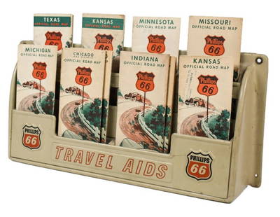
Sold2023Vintage Phillips 66 Road Map Embossed Display RackVintage Phillips 66 embossed plastic road map display rack full with original 1930s Phillips 66 maps. Rack has discoloration, some expected chips/ cracks, and wear from use and age. Displays well withSee Sold Price
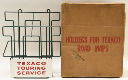
Sold2021Vintage NOS Texaco Road Map Metal Display RackVintage new old stock Texaco road map metal display rack in original box. Nice condition with light wear from age and storage. Display rack measures approximately 10-1/2" tall by 9" across.See Sold Price
Sold2020Road map of Southern California 1918Heading: (California) Author: Title: Automobile Road Map of Los Angeles, Orange, Riverside and San Bernardino Counties Place Published: Los Angeles Publisher:Security Trust & Savings Bank Date PSee Sold Price
Sold2018Auto road map of greater Los Angeles, 1916Heading: (California - Southern) Author: Parker, O.K. Title: Automobile Road Map of Los Angeles, Orange, Riverside and San Bernardino Counties Place Published: Los Angeles Publisher:Security Trust & SSee Sold Price
Sold2019Road-Map of England And WalesTitle: Road-Map of England And Wales Publication Date: 1835-03-25 Cartographer: BACON, G. W. & CO. Publisher: G.W. BACON & CO. Dimension: 33Height - 26.5Width Retailed by Forster Groom & Co. Ltd. DissSee Sold Price
Sold2024Misc. Lot including Roadmap Ephemera, Pocket Guide to Sex, Tru-Vue 3D PicturesMisc. Lot including Road map Ephemera, Pocket Guide to Sex, Tru-Vue 3D Pictures with viewerSee Sold Price
Sold2021Road Maps by Johnathan Schultz"Road Maps" by Johnathan Schultz is an original 3D sculpture created with 23kt gold leaf on Acrylic, 18kt gold plate. Frame Dimensions 13.5 x 13.5 x 4 inSee Sold Price
Sold2021Shell Tin Litho Road Maps DisplayCanadian. 1940s. Lithographed tin. Includes an assortment of seventeen (17) used road maps. Marked, "St. Thomas Metal Signs Ltd. St. Thomas Ontario" upper rear. 19 1/2 x 13". One added mounting hole tSee Sold Price
Jul 14Schilb Antiquarian Rare Books1939 John Ogilby Britannia Atlas MAPS 1ed 1675 facsim England Wales COLOR RoadUS$1
4 days LeftBid Again Auctions (American Space Museum)Apollo 10 Translunar / Transearth Trajectory Plotting Chart Signed by Tom StaffordUS$50
Jun 30Global Auctions CompanyHand Colored Engraved Map of Europe, Jean Baptiste Bourguignon Anville 1754US$450
5 days LeftClaydon Auctioneers LtdThree assorted 19thC Act of Parliament documents comprising George III 1808, Victorian 1866 & 1867.£30
Jun 27Rail & Road Auctions45 Peices of Western Railroad Paper Ephemera - Southern Pacific, Northern Pacific, Union Pacific,US$30(1 bid)
Jun 28Rail & Road AuctionsGroup of Fourteen Railroad Stock Certificates - Illinois Central, Denver & Rio Grande Western,US$30
Jun 27Rail & Road Auctions32 Pieces of Eastern and Canadian Railroad Paper - Erie, Erie Lackawanna, Canadian National,US$20
Jun 28Rail & Road AuctionsDiverse Group of Railroad Paper and Photos - Early 1900s N&W Telegrams, W&LE Photos and Yard Maps,US$30
Jun 27Rail & Road AuctionsChicago, North Shore & Milwaukee Railroad North Shore Line Playing CardsUS$50
Jun 27Rail & Road AuctionsTen Gulf, Mobile & Ohio Railroad Playing Card Decks - Alton Route Map and LogoUS$70
Jun 27Rail & Road AuctionsSix Union Pacific Railroad Items - Wall Lamp, China Plates, Travel Guide, Menu, and FramedUS$30
Jun 27Rail & Road AuctionsFour Camden & Atlantic Railroad Annual Passes - 1868, 1876, 1879, and 1889US$70
Jun 27Rail & Road AuctionsTwenty Norfolk Southern Railroad Promotional Items and Employee HandbooksUS$30


![[Maps] Britannia Depicta, 1720: Bowen, Emanuel. BRITANNIA DEPICTA OR OGILBY IMPROV'D; BEING A CORRECT COPPY OF MR. OGILBY'S ACTUAL SURVEY OF ALL YE DIRECT & PRINCIPAL CROSS ROADS IN ENGLAND AND WALES. London: Tho. Bowles, 1720. 8vo.](https://p1.liveauctioneers.com/3532/111460/57224161_1_x.jpg?height=310&quality=70&version=1509131847)