Sold2023Rare Antique OLNEY'S SCHOOL ATLAS, Maps 1844We have included quality images to show their condition. This lot is located in Boca Raton, Fl and its shipment will be made directly by Artelisted. Shipping insurance is the responsibility of the buySee Sold Price
Sold2017Perthes: Stieler's Antique School Atlas with Maps, 1865Map: Stieler's Schul-Atlas Uber Alle Theile Der Erde Cartographer: Stieler / J. Perthes Place & Date: Gotha / 1865 Size: 12" x 9 1/2" (each map) Condition: original outline color; overall age toning;See Sold Price
2017Burgess: Antique Map of the United States, 18531853 Map of the United States with large Texas. Daniel Burgess. Delightful early school atlas map of the region. Shows counties, parishes, towns, rivers, populations, Indian Tribes, Court Houses, FortSee Sold Price
Sold2024Antique Map of the World Cummings and HilliardCummings and Hilliard, The World, copper engraved hand colored map, sheet size 9.25 x 17.5 inches, framed 17 x 25.5 inches, from the 4th edition of School Atlas to Cummings' Ancient and Modern GeograpSee Sold Price
Sold2017Colton: Antique Map of Texas, 18641860 Colton’s Texas - uncommon. From an 1864 school atlas. This map is not seen very often. Delineates all counties to 1860. Shows topography, forts, railroads, battle fields, rivers, etc. �See Sold Price
Sold20211830 "A New Atlas World" Educational School Map Book1830 "A New Atlas World"Antique Educational School Maps. This is a wonderful antique atlas for early education, geography classes. It has a layout of the world and the breakdown of each continent. BecSee Sold Price
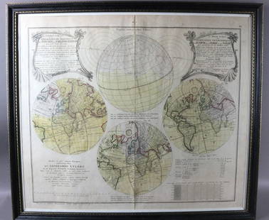
Sold20231747 Leonhard Euler Map of the World with Earth Eclipse & SolarFramed November 1747 Leonhard Euler Map of the World with earth and lunar eclipse including calculated degrees of the eclipse arriving 1748. This would be an important and timely prediction of a majorSee Sold Price
Sold2020EULER, LEONHARD. [Geographisher Atlas.]EULER, LEONHARD. [Geographisher Atlas.] Without title or text, 39 (of 44) double-page engraved maps with original hand-coloring (lacking the first two double-hemispheric maps, the XVII Provinces, andSee Sold Price
Sold2024Francis McNally - Antique Map of California & MinnesotaThis is a fine example of McNally's System of Geography by: Francis McNally, published by A.S. Barmes & Co. in 1875. This atlas was made for schools, academies, and seminaries to teach students aboutSee Sold Price
Sold2024Francis McNally - Antique Map of West IndiesThis is a fine example of McNally's System of Geography by: Francis McNally, published by A.S. Barmes & Co. in 1875. This atlas was made for schools, academies, and seminaries to teach students aboutSee Sold Price
Sold2024Francis McNally - Antique Map of Ohio, Indiana & KentuckyThis is a fine example of McNally's System of Geography by: Francis McNally, published by A.S. Barmes & Co. in 1875. This atlas was made for schools, academies, and seminaries to teach students aboutSee Sold Price
Sold2024Francis McNally - Antique Map of Washington, Oregon, Idaho, Nevada, Utah & ArizonaThis is a fine example of McNally's System of Geography by: Francis McNally, published by A.S. Barmes & Co. in 1875. This atlas was made for schools, academies, and seminaries to teach students aboutSee Sold Price
Sold2024Francis McNally - Antique Map of Nebraska, Kansas, Dakota, Colorado & MontanaThis is a fine example of McNally's System of Geography by: Francis McNally, published by A.S. Barmes & Co. in 1875. This atlas was made for schools, academies, and seminaries to teach students aboutSee Sold Price
Sold2024Francis McNally - Antique Map of Illinois, Missouri & IowaThis is a fine example of McNally's System of Geography by: Francis McNally, published by A.S. Barmes & Co. in 1875. This atlas was made for schools, academies, and seminaries to teach students aboutSee Sold Price
Sold2023Thomson, John (Pub) 1825 Antique Mountain & River Chart"View of some of the principal Rivers in the World" Copper Engraved Map Published 1825 by John Thomson, Edinburgh for "The Edinburgh School Atlas" by N. R. Hewitt. Maps Engraved by Hewitt. Original OuSee Sold Price
Sold2022Antique 1844 Hand Colored Olney's School Atlas Published by Pratt, Woodford, and Co.This is an antique Olney's School Atlas published in 1844 by Pratt, Woodford and Co of New York. The softbound volume features hand colored maps of regions of the United States and the world. CharmingSee Sold Price
Sold20211844 Mitchell's Ancient Atlas Map Book,Hand ColoredAntique Geography Book, Mitchell's Ancient Atlas 1844. A school instructional book "Containing Maps Illustrating Geography of the Ancient World". Published in Philadelphia by E.H. Butter & Co. DimensSee Sold Price
Sold2023A 19th century antique school atlas, handful of blank pages. Overall good condition.A 19th century antique school atlas, handful of blank pages. Overall good condition.See Sold Price
Sold2018Antique Buffier Map Atlas of the World, 1761Title/Content of Map: 1761 Buffier Map Atlas of the World -- Geographie Universelle Date Printed: 1761 Venice Cartographer: C. Buffier Size: 6.4 x 4 in. book; maps mostly pullout with folds This handsSee Sold Price
Sold2019Mitchell's School Atlas. Revised EditionTitle/Content of Map: Mitchell's School Atlas. Revised Edition Date: 1840 Cartographer: MITCHELL, SAMUEL AUGUSTUS Publisher: THOMAS, COWPERTHWAIT & CO Size: 12"H x 9.8"W Second issue. (contents on bacSee Sold Price
Sold2023ScotlandPublication Date: 1805 Title: Scotland Cartographer: HOOKER, SC. Height: 9.9 Width: 7.9 "From Genl. Roy's Map correct..." School atlas map. Later color. Reserve: $50.00 Shipping: Domestic: Flat-raSee Sold Price
Sold2021Lot of 4 Maps: ATLAS ANTIQUUS:12 MAPS OF ANCIENT WORLDLot of 4 Antique Maps from ATLAS ANTIQUUS: TWELVE MAPS OF THE ANCIENT WORLD by Heinrich Kiepert (1818-1899) | Published: Berlin, Dietrich Reimer, 1884-1885 | Each is a Double-Page Colored Map originatSee Sold Price
Sold2021Vintage Atlas School Map CabinetVintage Atlas School map cabinet, to include vintage world maps in wooden display case 19"h x 53.5"w x 4"d Provenance: The Estate of Barbara "Babs" Baugh (San Antonio, Texas) WeSee Sold Price
Sold2017Emigrant's Atlas: Antique Map of Michigan, 1849Map: Neueste Karte von Michigan Cartographer: Bibliographischen Instituts. Place & Date: Hildburghausen / 1849/1857 Size: 11 3/4" x 14 3/4" Condition: original color; water stain on lower part of map;See Sold Price
2 days LeftTrillium Antique Prints & Rare BooksKohler & Weigel - Map of Louisiana Territory or Eastern United States (extends from New Mexico toUS$120(4 bids)
2 days LeftTrillium Antique Prints & Rare BooksKohler & Weigel - Map of Sicily and SardiniaUS$85(2 bids)
2 days LeftTrillium Antique Prints & Rare BooksKohler & Weigel - Frontispiece with Globe and Sea Monster and GodUS$75
Jun 15Ladenburger Spielzeugauktion GmbHdoll's school utensils, satchel, 1 satchel, height: 12 cm, leather lugs are worn, tether is missing,€10
7 days LeftJasper52Cyprus. Famagusta Kerynia Larnaca Limassol Nicosia Paphos. STANFORD 1887 mapUS$340
7 days LeftJasper52Port of London. Royal Docks Tilbury Canary Wharf Surrey Quays. STANFORD 1904 mapUS$260
Featured7 days LeftJasper52World in hemispheres. Mountains & rivers. SWANSTON 1860 old antique map chartUS$260
7 days LeftJasper52Central Africa. Congo Free State Rhodesia German East Africa. STANFORD 1896 mapUS$280
7 days LeftJasper52Central Africa. Congo Free State Rhodesia German East Africa. STANFORD 1894 mapUS$280
7 days LeftJasper52The islands of Jersey & Guernsey, Sark, Herm… FADEN / DELAROCHETTE 1781 mapUS$280
7 days LeftJasper52The Falkland Islands surveyed by Captain Robert Fitzroy. STANFORD 1896 old mapUS$340
7 days LeftJasper52The Falkland Islands surveyed by Captain Robert Fitzroy. STANFORD 1894 old mapUS$340
7 days LeftJasper52Ionian Islands & Malta. Corfu Zante Kefalonia Kythira Lefkada. STANFORD 1896 mapUS$340
7 days LeftJasper52Zelanda, e parte orientale della Flandra. Flanders & Zeeland. CORONELLI 1696 mapUS$360
7 days LeftJasper52Bohemia Newly described by John Speed… 1626. Bassett/Chiswell edition 1676 mapUS$1,100
7 days LeftJasper52MILLWALL DEPTFORD Surrey & West India Docks Isle of Dogs Canary Wharf 1900 mapUS$260


![EULER, LEONHARD. [Geographisher Atlas.]: EULER, LEONHARD. [Geographisher Atlas.] Without title or text, 39 (of 44) double-page engraved maps with original hand-coloring (lacking the first two double-hemispheric maps, the XVII Provinces, and](https://p1.liveauctioneers.com/199/171650/86487384_1_x.jpg?height=310&quality=70&version=1592430092)


