Sold20241831 Woodbridge Maps of Climate, Vegetation and Animals of the World -- Isothermal Chart or View ofTitle: 1831 Woodbridge Maps of Climate, Vegetation and Animals of the World -- Isothermal Chart or View of Climates & Productions… [verso] Chart of the Principal Animals of the World CartographeSee Sold Price
Sold20231831 Woodbridge Maps of Climate, Vegetation and Animals of the World -- Isothermal Chart or View ofTitle: 1831 Woodbridge Maps of Climate, Vegetation and Animals of the World -- Isothermal Chart or View of Climates & Productions… [verso] Chart of the Principal Animals of the World CartographeSee Sold Price
Sold2022Lot of 10 Map-Sheets, 1855-56Lot of 10 map-sheets, mostly hand-colored, 5 double-page, authored by S.S. Cornell, comprising 21 loose maps (20 are hand-colored), 5 are double-page, plus full-page with 17 Principal U.S. Cities (insSee Sold Price
Sold20221831 Woodbridge Map of the United States -- Geographical & Statistical Map of the United States.Title: 1831 Woodbridge Map of the United States -- Geographical & Statistical Map of the United States. Adapted to Woodbridge's Geography Cartographer: W. Woodbridge Year / Place: 1831, Hartford Map DSee Sold Price
Sold20221831 Woodbridge Map of the United States -- Geographical & Statistical Map of the United States.Title: 1831 Woodbridge Map of the United States -- Geographical & Statistical Map of the United States. Adapted to Woodbridge's Geography Cartographer: W. Woodbridge Year / Place: 1831, Hartford Map DSee Sold Price
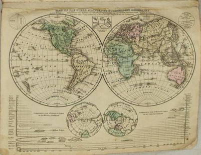
Sold20231831 Woodbridge Map of North America, Europe, Asia and on verso Map of Pacific Ocean -- PolarTitle: 1831 Woodbridge Map of North America, Europe, Asia and on verso Map of Pacific Ocean -- Polar Projection of North America and Asia [verso] Pacific Ocean with a View of Australia and Polynesia CSee Sold Price
Sold20221831 Woodbridge Map of North America, Europe, Asia andTitle: 1831 Woodbridge Map of North America, Europe, Asia and on verso Map of Pacific Ocean -- Polar Projection of North America and Asia [verso] Pacific Ocean with a View of Australia and Polynesia CSee Sold Price
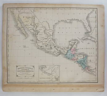
Sold20221831 Woodbridge Map of South America and Africa -- Comparative, Geographical & Statistical Map ofTitle: 1831 Woodbridge Map of South America and Africa -- Comparative, Geographical & Statistical Map of South America & Africa Cartographer: W. Woodbridge Year/Place1831, Hartford Dimensions: 10.8 XSee Sold Price
Sold2021Principal Cities of the World 1897Title/Content of Map: Principal Cities of the World 1897 Date Printed: 1897 Material/Medium: Paper Size: 14x19.5 inches Cram's Universal Atlas Reserve: $35.00 Shipping: Domestic: Flat-rate of $15.00See Sold Price
Sold20231888 Hand Book of the Pennsylvania Lines Containing Maps of Principal Cities - First EditionA first edition Hand-Book of the Pennsylvania Lines by L.G. McPherson, of the Passenger Department, Pennsylvania Lines West of Pittsburgh dated July 1888. The 81 page book is from the Pennsylvania RaiSee Sold Price
Sold20211831 Woodbridge World Map -- Map of the World AdaptedTitle: 1831 Woodbridge World Map -- Map of the World Adapted to Woodbridge's Geography Cartographer: W. Woodbridge Year / Place: 1831, Hartford Map Dimension (in.): 8.6 X 10.8 in. This is a very niceSee Sold Price
Sold20181846 Bradford Maps of Key US Cities -- Washington,Title/Content of Map: 1846 Bradford Maps of Key US Cities -- Washington, Louisville and Jeffersonville, New Orleans, Cincinnati Date: 1846 Boston Cartographer: T. Bradford Size: 11 x 13.5 in Well engrSee Sold Price
Sold2017Bradford: Antique Map of Four US Cities, 1838Title/Content of Map: Cities of Washington D.C., New Orleans, Cincinnati and Louisville Date Printed: 1838/1841 Cartographer: Thomas G. Bradford Material/Medium: Paper Size: 13" x 16 1/2" Hand coloredSee Sold Price
Sold2018Graessl: Antique Map of U.S. Southeast with city insetsDie Staaten N. & S. Carolina Georgia & Florida. A fascinating and beautifully colored map of the southeastern states of the U.S. in 1846, with inset maps of the "Gold Region of North Carolina" and theSee Sold Price
Sold2017ANTIQUE MAP of MITCHELL'S NATIONAL MAP of the AMERICANMap of 32 of Principal cities and towns. Publiched by S. Augustus Mitchell. Philadelphia. 41 1/4"h. x 53"w.See Sold Price
Sold2016Commercial Map of the US, Principal Lines of RailroadCommercial Map of the United States Showing The Principal Connecting Lines of Railroad David M Warrens 1879, Common School Geography 11.75 x 9.75 inches No Reserve: This lot starts at $1 and has no reSee Sold Price
Sold2024Group of Assorted Travel Guides and MapsIncludes famous American and British cities, museums, various U.S. maps and more, largest measures 11 x 8 1/2 inchesSee Sold Price
Sold2022SOCIETY FOR THE DIFFUSION OF USEFUL KNOWLEDGE The Complete Atlas of Modern, Classical and Celest...SOCIETY FOR THE DIFFUSION OF USEFUL KNOWLEDGE The Complete Atlas of Modern, Classical and Celestial Maps, together with Plans of the Principal Cities of the World, bound in 2 vol., 226 hand-colouredSee Sold Price
Sold2019PHILADELPHIA antique town city map plan. Inset US Bank,TITLE/CONTENT OF MAP: 'PHILADELPHIA' The top image on the right hand side shows the entire map. To view a close up of the map showing the level of printed detail, please click on the bottom image on tSee Sold Price
Sold2016U.S. Army Tokyo City Map for Stationed Soldiers, 1948Item: Map of the City of Tokyo, Japan Compiled by the U.S. Army 64th Engineer Battalion and updated in 1954 by the U.S. Army 29th Engineer BattalionDate: ca. 1948 Full Size: 28 1/2 x 37 1/4 inches FolSee Sold Price
Sold2020Grp: Maps of Western EuropeLot of seven maps of Western Europe. Includes Edward Wells (1667–1727), "A New Map of Present Germany, Shewing Its Principal Divisions, Cities, Towns, Rivers, Mountains, &c. Dedicated to His HiSee Sold Price
Sold2024BURR, David A. (1803-1875). Ohio. New York City, New York, 1831.BURR, David A. (1803-1875). Ohio. New York City, New York, 1831. Engraved map of the state of Ohio, visible area 10 1/8 x 12 1/2 inches. Showing counties, towns, and cities, with accurate road systemsSee Sold Price
Sold2017SDUK: Antique Map, City Plan of Philadelphia, 1847Title/Content of Map: 'PHILADELPHIA' Antique town city map plan. Inset US Bank, Exchange. Date Printed: 1847 Image Size: Approx 39.5 x 31.5cm, 15.5 x 12.5 inches (Large) Type: Antique steel engraved mSee Sold Price
May 12Schilb Antiquarian Rare Books1869 American Emigrants Immigration Illustrated US State MAPS Railroad AlaskaUS$1(1 bid)
May 10Rail & Road AuctionsEleven Army Corps of Engineers Port Series No. 1 Through No. 8 Books with Fold Out MapsUS$35(2 bids)
2 days LeftDoyle New YorkThomas Jefferson expresses fears of "a war of extermination" in Saint-DominigueUS$20,000
Featured2 days LeftJasper52RARE MAP, 1762, 15 Cities of the Safavid era Persian Empire by J. B. HomannUS$600
May 10Rail & Road AuctionsEleven Port Series Books with Fold Out Maps - No. 9 Through No. 23 - Army Corps of EngineersUS$20(1 bid)
2 days LeftAdam's AuctioneersH.C CAREY AND I.LEA (publishers) A Complete Historical, Chronological and Geographical AMERICAN€1,500(1 bid)
6 days LeftTremont Auctions1778 "Il Canada" original map depicting Canada and the US. Hand colored. Fold down center. Framed.US$150(1 bid)
2 days LeftDoyle New YorkThe Limited Editions Club edition of King's Letter from Birmingham City JailUS$500
2 days LeftDoyle New YorkThe top sheet of the famous Ratzer Map - with additions relating to an 1810 real estate disputeUS$7,500
May 12Schilb Antiquarian Rare Books1881 Westchester County New York Yonkers Illustrated MAPS 2v SET Bolton HistoryUS$16(2 bids)
1116 Lots AwayMynt AuctionsSARAH JESSICA PARKER SEX IN THE CITY ACTRESS BECKETT/COA SIGNED 8X10 PHOTOUS$10


![1831 Woodbridge Maps of Climate, Vegetation and Animals of the World -- Isothermal Chart or View of: Title: 1831 Woodbridge Maps of Climate, Vegetation and Animals of the World -- Isothermal Chart or View of Climates & Productions… [verso] Chart of the Principal Animals of the World Cartographe](https://p1.liveauctioneers.com/5584/319185/171438327_1_x.jpg?height=310&quality=70&version=1707858212)


![1831 Woodbridge Maps of Climate, Vegetation and Animals of the World -- Isothermal Chart or View of: Title: 1831 Woodbridge Maps of Climate, Vegetation and Animals of the World -- Isothermal Chart or View of Climates & Productions… [verso] Chart of the Principal Animals of the World Cartographe](https://p1.liveauctioneers.com/5584/285598/150695005_1_x.jpg?height=310&quality=70&version=1681855790)


![1831 Woodbridge Map of North America, Europe, Asia and on verso Map of Pacific Ocean -- Polar: Title: 1831 Woodbridge Map of North America, Europe, Asia and on verso Map of Pacific Ocean -- Polar Projection of North America and Asia [verso] Pacific Ocean with a View of Australia and Polynesia C](https://p1.liveauctioneers.com/5584/285598/150695018_1_x.jpg?height=310&quality=70&version=1681855790)
![1831 Woodbridge Map of North America, Europe, Asia and: Title: 1831 Woodbridge Map of North America, Europe, Asia and on verso Map of Pacific Ocean -- Polar Projection of North America and Asia [verso] Pacific Ocean with a View of Australia and Polynesia C](https://p1.liveauctioneers.com/5584/231769/120064716_1_x.jpg?height=310&quality=70&version=1641336545)


![[CIVIL WAR] New York Cartridge Box, DOW Chancellorsville (1 of 5)](https://p1.liveauctioneers.com/7226/325455/175169095_1_x.jpg?height=282&quality=70&version=1712370394)


