Sold2019Two Maps by Johnson & Browning, "Austria, Turkey,Two Maps by Johnson & Browning, "Austria, Turkey, Greece," 1859; together with "Northern and Southern Italy," 1860-1863, hand colored, Italy- H.- 26 1/2 in., W.- 36 in., Austria- H.- 18 in., W.- 26 1/See Sold Price
Sold2021After Hans Zatzka (B. March 8, 1859, Austria)After Hans Zatzka (B. March 8, 1859, Austria). Signed. Oil on Canvas. Measures 35 inches high x 38 inches wide in a 10 inch frame.See Sold Price
Sold2021EXCEPTIONAL 1859 MAP OF ORANGE/ROCKLAND COUNTIESEXCEPTIONAL 1859 MAP OF ORANGE/ROCKLAND COUNTIES, FF FRENCH, WE WOOD & S.N. BEERS PUB. CORY & BACHMAN, 65" X 62"See Sold Price
Sold2023United States of North America, Pacific States by Joseph Wilson Lowry 1859 mapDescriptionCAPTION PRINTED BELOW PICTURE: The United States of North America, Pacific States [including California, Oregon, Washington, Utah, and part of New Mexico, ]The map shows Washington, Oregon,See Sold Price
20231859 Map of Texas. By ColtonTitle: 1859 Map of Texas. By Colton Date/Period: 1859 Materials: Hand colored steering engraved Size: 17 1/2 x 14 1/2” br>Texas right before the civil war, inserts the northern part of the stateSee Sold Price
Sold20231859 Map of Texas. By ColtonDescriptionTitle: 1859 Map of Texas. By ColtonDate/Period: 1859Materials: Hand colored steering engravedSize: 17 1/2 x 14 1/2”br>Texas right before the civil war, inserts the northern part of thSee Sold Price
Sold20221859 MAP OF MANHATTAN (FASCIMILE OF 1664) 21 X 271859 MAP OF MANHATTAN (FASCIMILE OF 1664) 21 X 27See Sold Price
20231859 Map of Florida by ColtonTitle: 1859 Map of Florida by Colton Date/Period: 1859 Materials: Steel engraved Size: 17 1/2 x 14 1/2” Florida with Florida keys in the insert. From before the civil war. By J. H. Colton & G. WSee Sold Price
Sold2023Burmah, Siam & Anam. Indochina Shan States Thailand Vietnam. WELLER 1859 mapCAPTION PRINTED BELOW PICTURE: 'Burmah, Siam, and Anam' DATE PRINTED: 1859 IMAGE SIZE: Approx 37.0 x 27.0cm, 14.5 x 10.75 inches (Large) TYPE: Antique engraved atlas map with original hand colour/coloSee Sold Price
Sold2023New Zealand Sandwich Galapagos Islands. Papuan Archipelago. Melanesia 1859 mapNew Zealand. // Sandwich Islands, or Hawaiian Group, // Galapagos Islands // Papuan Archipelago' by John Bartholomew (1859). Antique engraved atlas map with original hand colour/color, 37.0 x 53.5cm,See Sold Price
Sold20231859 Map of Florida by ColtonTitle: 1859 Map of Florida by Colton1859 Materials: Steel engraved Size: 17 1/2 x 14 1/2” Florida with Florida keys in the insert. From before the civil war. By J. H. Colton & G. W. Colton. From "GeSee Sold Price
Sold20211859 Map of New Amsterdam, (Manhattan) AS IS. 30" X 24"1859 MAP OF New Amsterdam (Manhattan)AS IS. 30" X 24". This map is actually a rendering after a 1664 map made in 1859.See Sold Price
Sold20231859 Map of Washington and Oregon territory includes modern Idaho by ColtonTitle: 1859 Map of Washington and Oregon territory includes modern Idaho by Colton Date/Period: 1859 Materials: Steel engraved Size: 17 1/2 x 14 1/2” Washington and Oregon territories with whatSee Sold Price
Sold20231859 Map of Boston and surrounding communities by ColtonTitle: 1859 Map of Boston and surrounding communities by Colton Date/Period: 1859 Materials: Steel engraved Size: 17 1/2 x 14 1/2” br>Boston and surrounding communities. Shows, rivers, lakes, coSee Sold Price
Sold20231859 Map of Massachusetts and Rhode Island. Insert of Boston by ColtonTitle: 1859 Map of Massachusetts and Rhode Island. Insert of Boston by Colton1859 Materials: Steel engraved Size: 17 1/2 x 14 1/2” Massachusetts and Rhode Island. With insert of Boston and surroundiSee Sold Price
Sold2020Antique 1859 Map of Kendall County IllinoisBy L. J. Bennett, 45 x 51 inches some damageSee Sold Price
Sold20231859 Map of Connecticut by ColtonTitle: 1859 Map of Connecticut by Colton Date/Period: 1859 Materials: Steel engraved Size: 17 1/2 x 14 1/2” Connecticut. Shows, rivers, lakes, counties cities, towns, villages, roads, and rail lSee Sold Price
Sold20211859 Map of the USTitle: 1859 Map of the US Author: Chambers Medium: Ink on Paper Dimensions: 11.5"X9.5" Description: Map of the United States dated 1859. Part of the Modern & Ancient Geography Atlas. Engraved by J.GelSee Sold Price
Sold20211859 Map of PalestineTitle: 1859 Map of Palestine Author: Chambers Medium: Ink on Paper Dimensions: 9.5"X11.5" Description: Map of Palestine dated 1859. Part of the Modern & Ancient Geography Atlas. Engraved by J.GellatlySee Sold Price
Sold20231859 Map of Illinois, with Chicago, insert by ColtonTitle: 1859 Map of Illinois, with Chicago, insert by Colton Date/Period: 1859 Materials: Steel engraved Size: 17 1/2 x 14 1/2” Illinois with an insert of Chicago. By J. H. Colton & G. W. Colton.See Sold Price
Sold20211859 Map of CanadaTitle: 1859 Map of Canada Author: Chambers Medium: Ink on paper Dimensions: 11.5"X9.5" Description: Map of Canada dated 1859. Part of the Modern & Ancient Geography Atlas. Engraved by J.Gellatly. PublSee Sold Price
Sold20201859 Map of MexicoTitle: 1859 Map of Mexico Author: Johnson Medium: Ink on Paper Dimensions: 18"x14" Map of Mexico dated 1859. Engraved by A.J. Johnson. Published by Johnson and Ward in New York. Johnson is consideredSee Sold Price
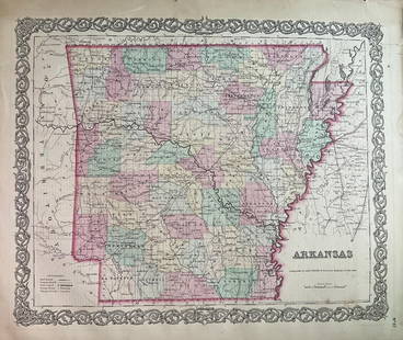
Sold20231859 Map of Arkansas by ColtonTitle: 1859 Map of Arkansas by Colton Date/Period: 1859 Materials: Steel engravedSize: 17 1/2 x 14 1/2” Arkansas. From before the civil war. By J. H. Colton & G. W. Colton. From "General Atlas".See Sold Price
Sold20201859 Map of Washington state, Oregon and IdahoAuthor: Johnson Title: 1859 Map of Washington state, Oregon and Idaho Medium: Ink on Paper Dimensions: 18"X14.5" Map of Washington state and Oregon dated 1859. Engraved by A.J. Johnson. Published by JSee Sold Price
Featured6 days LeftJasper52United States of North America. Early territorial boundaries. LOWRY 1859 mapUS$380
6 hrs LeftMerrill's Auctioneers and Appraisers1859 Walling Map of Orleans, Lamoille, Essex VTUS$175(2 bids)
5 days LeftJasper521801 Cary Map of Austria -- A New Map of the Circle of Austria from the Best AuthoritiesUS$95
5 days LeftJasper52Austria-Hungary Rand, McNally & Co.'S Indexed Atlas of the World Map of Austria-Hungary.US$70
6 days LeftJasper52AUSTRALIAN COLONIES w/ counties. Predates Queensland (Est. 1859). SDUK 1857 mapUS$380
1 day LeftTrillium Antique Prints & Rare BooksHomann - 3 Maps of Czech Republic, Austria, RussiaUS$100
6 days LeftJasper52Atlanta Karte der Besatzungs-Zonen. Map of the Occupation Areas of Germany 1946US$440
6 days LeftJasper52Germaniae Tabula. Germany, Switzerland, Austria & Czechia. MÜNSTER 1572 mapUS$400
1 day LeftArader GalleriesGiacomo Gastaldi Map of the Venetian Republic, Kingdom of Hungary and Holy Roman EmpireUS$24,000
6 days LeftJasper52United States of North America, Pacific States by Joseph Wilson Lowry 1860 mapUS$340
6 days LeftJasper52United States of North America. Early territorial boundaries. LOWRY 1860 mapUS$380
1 day LeftTrillium Antique Prints & Rare BooksNodder, Watercolor - Idomeneus or Great Occidental Butterfly. 164US$50


![United States of North America, Pacific States by Joseph Wilson Lowry 1859 map: DescriptionCAPTION PRINTED BELOW PICTURE: The United States of North America, Pacific States [including California, Oregon, Washington, Utah, and part of New Mexico, ]The map shows Washington, Oregon,](https://p1.liveauctioneers.com/5584/311630/167410815_1_x.jpg?height=310&quality=70&version=1701439692)


![[MAPPING] LOT OF 3 VOLS + 5 LOOSE MAPS TOGETHER (1 of 6)](https://p1.liveauctioneers.com/8124/343618/186530166_1_x.jpg?height=282&quality=70&version=1726178725)

![[NORTH WEST AMERICA, BIBLIOGRAPHY] LOT OF 6 VOLS (1 of 3)](https://p1.liveauctioneers.com/8124/343618/186530117_1_x.jpg?height=282&quality=70&version=1726178725)


