Sold2018Antique Government Map of Nashville Railroads, 1887Title/Content of Map: 1887 Government Map of Nashville Railroads -- Nashville, Tenn Date Printed: 1887, Washington DC Cartographer: Dept. of Interior Size: 6.5 X 9.5 in. Simple, yet eloquent map of NaSee Sold Price
Sold20241871 Cincinnati Surveyor Map of Railroad Lines, Mill CreekAmerica, 19th century. A folio containing two maps of proposed areas for railroad lines in the Spring Grove area of Cincinnati. Concerning the land of Peter Neff. 440See Sold Price
Sold20231886 Cincinnati Plumbing & Sewage Plan, Seth C. Foster EsqAmerica, 19th century. A large hand drawn map of downtown Cincinnati detailing plumbing anf sewing plans from 1886. Property of the Seth C. Foster Esq. Various colors highlight areas of wood work, wasSee Sold Price
Sold2021Ext. scarce 1910 railroad map of CincinnatiAn unusual map showing not only the railroad lines running through Cincinnati in the early part of the 1900s, but also depicting every streetcar route as well. From an extremely scarce atlas, one of tSee Sold Price
Sold2017Railroad Annual Passes (4)A group of 4 annual passes that includes" New York & New England 1880 - map on reverse P. W. Strader & Co 1871 - Cincinnati stage line, Jeffersonville with impossible to read lettering - very old locoSee Sold Price
Sold20231882 Cincinnati Planning Map, The United Railroads Stock Yard Co, Spring Grove Ave, and RailroadAmerica, 19th century. A hand drawn planning map of Cincinnati, Ohio from April 1882. Shows multiple railroad lines including C & B Railway and C H & D Railway to make the United Stock Yard CoSee Sold Price
Sold2017Mitchell: Railroad & Steamboat Map of the US, 1887Map: 1887 Mitchell Railroad and Steamboat Map of the US -- Railroad Map of the United States, Showing the through Lines of Communication from the Atlantic to the Pacific. Together with the Various SteSee Sold Price
Sold2022Hand colored Map of Pittsburgh & CincinnatiGray's Atlas Map of Pittsburgh & Allegheny County and Cincinnati, Ohio Depicts railroad lines, common roads, canals, topography, etc. A beautiful & rare map. Cartographer: <See Sold Price
Sold20241882 Cincinnati Planning Map, The United Railroads Stock Yard Co, Spring Grove Ave, and RailroadAmerica, 19th century. A hand drawn planning map of Cincinnati, Ohio from April 1882. Shows multiple railroad lines including C & B Railway and C H & D Railway to make the United Stock Yard CoSee Sold Price
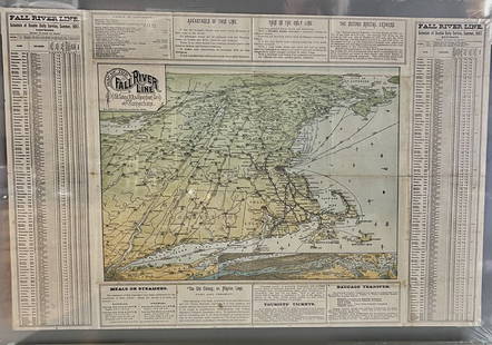
Sold2023Fall River Line, Old Colonial Railroad & Steamship Companies and CommunitiesOriginal Map. ca. 1887See Sold Price
Sold20211887 Mitchell Railroad Map of the United States --Title: 1887 Mitchell Railroad Map of the United States -- Railroad Map of the United States, Showing the through Lines of Communication from the Atlantic to the Pacific. Together with the Various SteaSee Sold Price
Sold2016Rand, McNally & Co.: West Mississippi West Coast 1887Map: Map Exhibiting the Leading Transportation Lines of the Pacific Coast. Prepared for The Report of The Chief Of The Bureau Of Statistics On The Internal Commerce Of The United States Publishing: RaSee Sold Price
Sold20191886 RR Map of U. S. also shows Steamship linesVery clean, interesting and informative railroad map of the United States from Mitchell's 1887 New General Atlas, with important information on the late 19th century United States. Titled “RailroadSee Sold Price
Sold2023Fly CAT / See Taiwan. Government Information Office, Republ...Fly CAT / See Taiwan. Government Information Office, Republic of China, ca. 1960s. Pictorial airline travel poster map of Taiwan. CAT’s routes and airports are marked with pink lines and red dotSee Sold Price
Sold2021Government map of Indian TerritoriesHeading: (Indian Territory) Author: Dinsmore, A. F., Lowe, R.P., Naylor, William, Cartographers Title: Indian Territory. Department of The Interior General Land Office. Hon. Thomas H. Carter, CommissiSee Sold Price
Sold2022GERMANTOWN PA TOWNSHIP LINE DRAWN MAPDRAFT OF THE TOWNSHIP LINE ROAD FROM THE TOP OF LIVEZEY'S HILL TO NORRIS CORNERSee Sold Price
Sold2022Heyman Tract in Noe Valley for saleHeading: -1891 Author: Munch, R. Title: Map of the Heyman Tract Place Published: San Francisco Publisher:Francis, Valentine & Co., Print. Date Published: 1891 Description: Blue-lSee Sold Price
Sold2022De Boom Tract San Francisco 1887Heading: -1887 Author: Title: Map of the De Boom Tract as Subdivided into 198 LotS Place Published: San Francisco Publisher:Bosqui Eng. Co. Date Published: 1887 Description: LiSee Sold Price
Sold2022Bancroft's large folding map of S.F. 1887Heading: -1887 Author: Title: Bancroft's Official Guide Map of City and County of San Francisco, Compiled from Official Maps in Surveyor's Office Place Published: San Francisco Publisher:The BancroftSee Sold Price
Sold2022Payne/Low, Map of Tennessee Government, 1799A MAP OF THE TENNASSEE[sic] GOVERNMENT FROM THE LATEST SURVEYS, 1799, engraved for John Payne's NEW AND COMPLETE UNIVERSAL GEOGRAPHY, published by John Low, New York, 1799. This early copperplate engrSee Sold Price
Sold2023PROEHL, Pauline. United Air Lines Mainliner Vacation Map. 1...PROEHL, Pauline. United Air Lines Mainliner Vacation Map. 1940s. Poster map of the United States, with a route of United Air Lines’ Mainliner service to “the Nation’s Greatest VacatiSee Sold Price
Sold2022London Tube Railways. 11 proposed new/extended Underground lines HMSO 1901 mapTITLE/CONTENT OF MAP: 'London tube railways 1901' This fascinating map, drafted by the Civil Engineer Sir Alexander Binnie in his capacity as Chief Engineer of London County Council, shows the developSee Sold Price
Sold2023Five Antique American MapsFive Antique American Maps, incl. "Map of Oregon and Upper California..." 1848, Charles Preuss; "map of Connecticut Showing the System of Trunk Line Highways...", 1932; "Map of the Valley of Mexico",See Sold Price
Sold2022Original Map of Atlantic City 1887Artist: Unknown Artist Title: Map of Atlantic City Year: 1877 Dimensions: 21in. by 31in. Edition: From the Rare Limited Edition Condition: ExcellentSee Sold Price
4 days LeftRail & Road AuctionsCleveland, Cincinnati, Chicago and St. Louis Railway Dietz Vesta Lantern and 1918 Rules BookletUS$30
4 days LeftRail & Road AuctionsChicago, North Shore & Milwaukee Railroad North Shore Line Playing CardsUS$50
3 days LeftJasper521857-58 Emory Map of Western United States -- Map of the United States and Their Territories BetweenUS$220
5 days LeftSwann Auction Galleries(CIVIL WAR--PRINTS.) Ethan Blodgett. Map of a Portion of Roanoke Island, Showing the Battlefield ofUS$750
6 days LeftJM Hobby Supply and Railroad Artifact AuctionsCripple Creek and Colorado Springs RY Handlan-Buck Switch LanternUS$500(1 bid)
6 days LeftJM Hobby Supply and Railroad Artifact AuctionsCripple Creek and Colorado Springs RY Handlan-Buck Caboose LanternUS$500(1 bid)
3 days LeftEldred'sCOLLECTION OF ANNUAL REPORTS OF THE BUREAU OF AMERICAN ETHNOLOGY TO THE SECRETARY OF THE SMITHSONIANUS$750(1 bid)
3 days LeftUniversity ArchivesRobert Louis Stevenson Boldly Signed Check Dating from Period When "Underwoods," Bilingual PoetryUS$300
5 days LeftSwann Auction Galleries(WEST--TEXAS.) David B. Edward. The History of Texas; or, The Emigrant's, Farmer's, and Politician'sUS$1,500
12 hrs LeftSchilb Antiquarian Rare Books1877 Geology Geography Surveys 1ed Nevada Wyoming Utah George Wheeler US West 2vUS$14(4 bids)
5 days LeftRail & Road AuctionsGroup of Fourteen Railroad Stock Certificates - Illinois Central, Denver & Rio Grande Western,US$40(2 bids)
1 day LeftActivity AuctionsLONDON UNDERGROUND tube map plan diagram. 2nd HARRY BECK edition. August 1933US$1,700
Jul 11Potter & Potter AuctionsCircus Sports. New York: McLoughlin Bros., 1887. Color lith...US$150(1 bid)


![Payne/Low, Map of Tennessee Government, 1799: A MAP OF THE TENNASSEE[sic] GOVERNMENT FROM THE LATEST SURVEYS, 1799, engraved for John Payne's NEW AND COMPLETE UNIVERSAL GEOGRAPHY, published by John Low, New York, 1799. This early copperplate engr](https://p1.liveauctioneers.com/525/230966/119655004_1_x.jpg?height=310&quality=70&version=1640205832)


![[Literature] Haggard, H. Rider: King Solomon's Mines (1 of 2)](https://p1.liveauctioneers.com/65/332523/179335141_1_x.jpg?height=282&quality=70&version=1717622830)


