Sold2023An Illustrated Catalogue and Guide Book to Barnum’s America...AN ILLUSTRATED CATALOGUE AND GUIDE BOOK TO BARNUM’S AMERICAN MUSEUM. New York: Printed and Published for the Proprietor (Wynkoop, Hallenbeck & Thomas, Steam Book and Job Printers), ca. 1850. OriSee Sold Price
Sold2023Seutter - Map of North America including Great Lakes, Florida, Virginia, New England, Mexico, WestThis engraving is from a composite atlas presented by the Homann Heirs. Many of the maps in the collection were completed by J. B. Homann, Homann Erben, M. Seutter, and T. C. Lotter. The maps were oriSee Sold Price
Sold2017Robert Morden - English Plantations in AmericaRobert Morden (d. 1703) and William Berry (fl. 1669-1708) makers A New Map of the English Plantations in America both Continent and Ilands Shewing their true Situation and distance from England or oneSee Sold Price
Sold2024Currier and Ives America Book with Colored PlatesIncludes 80 colored plates. Some discoloration to pages and binding.See Sold Price
Sold2024Stanford, Edward 1901 Large Map. British Isles - Railway MapLarge Folio Lithograph Map Published 1901, London for "Stanford's London Atlas of Universal Geography" by Edward Stanford. Centre fold as published. Paper Size: 29 x 21.5 inch (74 x 55cm) Very minor tSee Sold Price
Sold2021San Antonio Conservation Society 1926 MapVintage 1926 San Antonio Conservation Society historic guide map of San Antonio de Bexar, drawn by Emily Edwards, portrays San Antonio from 1682-1721, unframed 39 x 28"; Provenance: A Schertz, TX EsSee Sold Price
Sold2024Glasgow Geography 1825 Antique Map. North America USA CanadaCopper Engraved Map Published 1825, Glasgow for "The Glasgow Geography?" by Several Literary Gentleman. Folds as issued. .Paper Size: 11 x 8 inch (28 x 21cm) Good ConditionSee Sold Price
Sold2024Rapkin, John 1860 Antique Map. North America. USA CanadaSteel Engraved Map Published 1860 by The London Printing & Published Company, London for "The Royal Dictionary-Cyclopedia for Universal Reference" by Thomas Wright. Drawn & Engraved by John Rapkin. FoSee Sold Price
Sold2024Clarke & Russell 1814 Hand Col Map. South AmericaHand Colored Copper Engraved Map Published 1814-27, London for "A New Geographical Dictionary; Containing a Description of all the Empires, Kingdoms, States and Provinces..." by J. W. Clarke. Drawn anSee Sold Price
Sold2024Johnson & Exley 1812 Antique Map. South AmericaCopper Engraved Map Published 1812, London for "The Imperial Encyclopaedia; Or, Dictionary of the Sciences and Arts" by William Moore Johnson & Thomas Exley. Paper Size: 10.5 x 8.5 inch (27 x 22cm) WaSee Sold Price
Sold2024Blackie (Pub) 1882 Folio Map. North America USA CanadaLithograph Map Published 1882 by Blackie & Son, London for "The Comprehensive Atlas & Geography of the World" by W. G. Blackie. Centre fold as published. Paper Size: 22 x 15 inch (56 x 38cm) Good condSee Sold Price
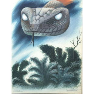
Sold2023Miguel Covarrubias, illustration from Green MansionsMIGUEL COVARRUBIAS (Mexican, 1904-1957), Illustration for the book "Green Mansions" by William Henry Hudson, watercolor, (approximate dimensions - sheet (sight): 10 1/2 x 8 inches); "for Paul" and sigSee Sold Price
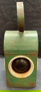
Sold2023Antique Chalwyn Railway Lantern, EnglandAntique 20th century English Chalwyn railway lantern. Green enameled Metal. Made in England. Antique English warning lantern used in early railways as warning signals. Surface wear including loss to eSee Sold Price
Sold2024John Bowles (British 1709 - 1779)John Bowles (British 1709 - 1779) "A New and Exact Map of America Laid Down from the Latest Observations and Discoveries", circa 1750 Two sheet map engraving of the "Representation of the Customs andSee Sold Price
Sold2022Book Cadillac Hotel w/Crest Porcelain SignRated 7.75, 61" x 27.5", SSP vertical lighthouse sign, has good color and gloss, has chips in the field and around the perimeter, has been put in a wood frame. The Authentication Company #037705See Sold Price
Sold20201761 MAP OF NORTH AMERICA BY ROCQUE18th century map GENERAL MAP OF NORTH AMERICA 1754-1761 by John Rocque, London by A. Drury, 2 part map, 35.5 x 36 inches, good condition.See Sold Price
Sold2016Map of North America...David H. Vance, engraved by J.H. Young. Philadelphia: Anthony Finley, 1825. Engraved map in 5 parts with original hand color in outline. 25 7/8 x 20 1/2 inches sheet, 30 5/8 x 25 1/2 inches framed.See Sold Price
Sold2024Clarke & Russell 1814 Hand Col Map. States of AmericaHand Colored Copper Engraved Map Published 1814-27, London for "A New Geographical Dictionary; Containing a Description of all the Empires, Kingdoms, States and Provinces..." by J. W. Clarke. Drawn anSee Sold Price
Sold2024Glasgow Geography 1825 Antique Map. United States of AmericaCopper Engraved Map Published 1825, Glasgow for "The Glasgow Geography?" by Several Literary Gentleman. Folds as issued. .Paper Size: 11 x 8 inch (28 x 21cm) Good ConditionSee Sold Price
Sold2024Blackie (Pub) 1882 Folio Map. Canada - British North AmericaLithograph Map Published 1882 by Blackie & Son, London for "The Comprehensive Atlas & Geography of the World" by W. G. Blackie. Centre fold as published. Paper Size: 22 x 15 inch (56 x 38cm) Good condSee Sold Price
Sold2023PRE COLUMBIAN AMERICA OLMEC MASK MADE OF DARK JADEAn ancient Olmec mask from Pre Columbian America made of dark green jade. It is a mans face with a stern, hard expression. The mask has harshly carved facial features, eyes with drilling holes in theSee Sold Price
Sold2024Glasgow Geography 1825 Antique Map. Canada - British Possessions in AmericaCopper Engraved Map Published 1825, Glasgow for "The Glasgow Geography?" by Several Literary Gentleman. Folds as issued. .Paper Size: 11 x 8 inch (28 x 21cm) Good ConditionSee Sold Price
Sold2024Map of United States of North America, 1785Map of United States of North America, 1785, The Royal Islands of Newfoundland. 26 3/4 x 32 3/4 in framed. 19 x 25 in unframed.Local Pick up call one day before to make an appointment. TO SHIP THIS ITSee Sold Price
Sold2023Antique 1805 Map of the United States of America On Silk School Girl LivingstonAntique map of the United States on silk. Made by a school girl Mary Livingston 1805. Survives in excellent condition as it was discovered in a blanket chest along the Hudson River from an estate a feSee Sold Price
4 days LeftHess Fine Auctions1885 A Popular History Of The United States JC Ridpath Gilt Green Leather Book IllustratedUS$10
Jun 01Link Auction GalleriesHandbook of the United States of America, and Guide to Emigration; Giving the Lastest and MostUS$50
20 hrs LeftTrillium Antique Prints & Rare BooksBraun & Hogenberg, pub. 1575 - View of Chios, GreeceUS$120(2 bids)
20 hrs LeftTrillium Antique Prints & Rare BooksCatherwood - Portion of a Building; Las Monjas, UxmalUS$500
5 days LeftConcept Art GalleryLeonor Fini Temps de la Mue Complete Portfolio 20 signed etchingsUS$800(1 bid)
Jun 02Schilb Antiquarian Rare Books1863 Emancipation of SLAVERY in America CIVIL WAR French Colonies Cochin RAREUS$1
Jun 02Schilb Antiquarian Rare Books1831 PIRATES in America TORTUGA Capt Morgan Buccaneers Drake Cavendish VoyagesUS$70(5 bids)
Jun 02Schilb Antiquarian Rare Books1889 Occult SECRETS 1st/1st Wise Men Chemist Physicians MAGIC Skills MedicineUS$90(4 bids)
Jun 02Schilb Antiquarian Rare Books1898 Our Country in WAR United States America Revolution Battles Mexico SpainUS$46(5 bids)
Jun 02Schilb Antiquarian Rare Books1848 RARE Halls of Montezumas MEXICO Texas America War Zachary Taylor BattlesUS$3(3 bids)
Jun 02Schilb Antiquarian Rare Books1871 Holy BIBLE & MAPS Holy Land Hitchcock Analysis Gruden Concordance TheologyUS$120(3 bids)
Jun 02Schilb Antiquarian Rare Books1855 The Republican Court 1ed Americana George Washington Portraits Social FeminismUS$1(1 bid)
Jun 02Schilb Antiquarian Rare Books1850 Colton Voyages California San Francisco Brazil Slave Trade Peru Deck & PortUS$1(1 bid)
232 Lots AwayLEAP Auctions(3) Books with Protective Case on Hunting in Northwestern AmericaUS$50(3 bids)