Sold20221937 Red Indian Pathfinder Road Map of Ontario Quebec Maritime Provincesin good condition, 9"x4", has a ink stamp of the service station's address at the top, light soiling.See Sold Price
Sold20198 Various Road MapsLot contains Parco, 1931 Sinclair, early Monamotor, 1937 Red Indian, Sinclair, General Violet Ray, early Deep Rock, early Richfield, and 1953 Hancock. Great graphics maps that show good color with somSee Sold Price
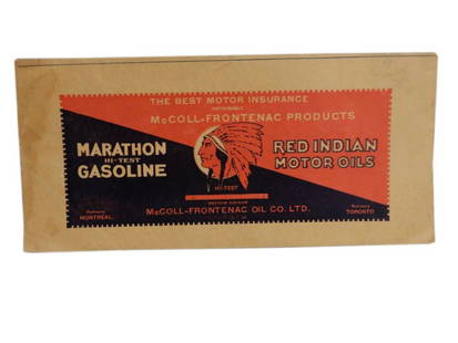
Sold20171936 McColl-Frontenac Red Indian Road Map8.75” x 3.75” folded & 35” x 21” unfolded. 1936 McColl-Frontenac Red Indian Road Map. An exceptionally graphic road map of Ontario, Quebec and Maritime Provinces. Very Good condition with miniSee Sold Price
Sold20201933 McCOLL-FRONTENAC SASKATCHEWAN ROAD MAP MAP &1933 McCOLL-FRONTENAC SASKATCHEWAN ROAD MAP MAP & ADVERTISING, SOME STAINING & WEAR, EXCELLENT COVER ADVERTISING RED INDIAN GASOLINE & MOTOR OIL, 11" X 5.25"See Sold Price
Sold20222-Shell & 2-Esso 1937 Road Mapsrated 7 to 8, 9"x4" or less in size, all have good color, one shell has more wear than the others, Detroit, California, Pennsylvania & other.See Sold Price
Sold2023Dale Chihuly glass sculptureDale Chihuly (American 1941-) Indian Red Macchia Set with Windsor Green Lip Wraps 5 piece glass sculpture, 1986, siSee Sold Price
Sold20231926-38 22 Vintage Northeast U.S. Road MapsIncludes 1936 Texaco NC & SC Road Map; 1938 Texaco PA Road Map; 1928 Standard Oil Road Map of Middle Atlantic States; 1937 Texaco NY & Long Island NJ Road Map; 1937 Texaco DE, MD, VA, WV, NC & SC RoadSee Sold Price
Sold2023(6) VINTAGE BARBIE OUTFITS(6) VINTAGE BARBIE OUTFITS (6) outfits including Open Road (sweater-needs snap fixed,pants,coat,hat,red cork shoes,road map,red glasses), Wedding Date (gown, jewelry,veil), American Airlines (bodysuitSee Sold Price
Sold2019George Cram’s "Rail Road Map, Texas and IndianGeorge Cram’s "Rail Road Map, Texas and Indian Territory," 1900, H.- 18 3/8 in., W.- 26 3/4 in.See Sold Price
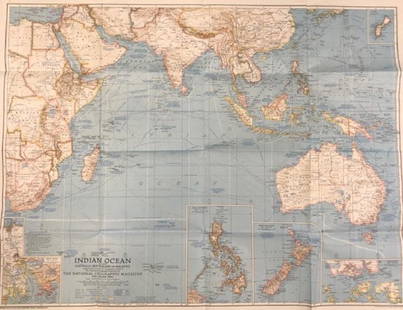
Sold2018Indian Ocean Map 1941Indian Ocean Map : Australia, New Zealand and Malaysia. National Geographic magazine. Date: 1941. Editor: Gilbert Grosvenor. Measurement approximate: 25 x 32. Shipping cost: $15.00 excluding Hawaii, ASee Sold Price
Sold2024Six Books of Shakespeare Selected PlaysVolumes 1-4 of Selected Plays of Shakespeare, published by the American Book Company in 1941, 1937, and 1936. Maps of the UK and London on End Pages. Two copies of Julius Cesar by William Shakespeare,See Sold Price
Sold20221937, 1938 & 1940 Union Oil Company Road Mapsrated 8, 9"x5", all have very good color, very light wear.See Sold Price
Sold2018Dale Chihuly (American, b. 1941) Cobalt Blue andDale Chihuly (American, b. 1941)Cobalt Blue and Indian Red Venetian Vase, 1988<See Sold Price
SoldMammoth Cave Sign & Other EphemeraMammoth Cave Sign & Other Ephemera- Johnson Wax tri-fold postcard, Road Map of Germany, 1945 Pathfinder magazines, Early 1900's Business Logo envelopes F Emmert Brewing Company of St. Paul, Minn. 2 LaSee Sold Price
Sold20223-Circa 1930's Roosevelt Highway Road Mapsrated 7 to 8, 9"x4" or less in size, red one has yellowing on front, all are folding maps.See Sold Price
Sold20221937 Montana, River Lines San Francisco & Pacific Northwest Road Mapsrated 8, 9"x4.5", all have good color.See Sold Price
Sold2020Rare road map from Bridgeport to Reno & TahoeHeading: (California) Author: Title: Mono Lake & Bridgeport to Lake Tahoe & Reno Place Published: Los Angeles Publisher:Automobile Club of Southern California Date Published: 1937 DescSee Sold Price
Sold2023Official Road Map of FloridaPublication Date: 1936 Title: Official Road Map of Florida Cartographer: Mid West Map Co. Publisher: Mid West Mao Co. Height: 20 Width: 16 Front panel imprinted in red, "Compliments of New American HoSee Sold Price
Sold2022Antique Folding Road Map of Southeast of FranceMap showing a "Grands Itineraires" possibly a road trip for an early steam driven automobile. With many distances noted from point to point. In black, blue and red inks on a heavy rag paper mounted inSee Sold Price
Sold2024Vintage 1920s Rand McNally Auto Trails MapMarked on upper corner Rand McNally Official Auto Trails Map of The United States, copyright by Rand McNally & Company. Depicts the whole of the United States with Trails and marked roads in red alongSee Sold Price
Sold2020Vintage National Geographic Magazine map of the IndianDescription: Vintage color paper map from National Geographic Magazine depicting the Indian Ocean. Copyright 1941. Material: paper. Measurement: approximate 26.5"h x 34"w (INCHES). Shipping cost: $12;See Sold Price
Sold2019Frances Cooke MacGregor Indian Portrait, Photo '37Frances Cooke MacGregor, American 1906-2001, Portrait of an Native American Woman, gelatin silver photograph, 1937, used as the cover image of the author's 1941 book "Twentieth Century Indians", inscrSee Sold Price
May 09Rail & Road AuctionsEight Canadian Pacific Railway Dining Car Menus - Spiral Tunnels, Mountie and Indian Chief, and MoreUS$30
May 09Rail & Road AuctionsChicago, North Shore & Milwaukee Railroad North Shore Line Playing Cards CompleteUS$50
May 09Rail & Road AuctionsChicago, North Shore & Milwaukee Railroad North Shore Line Playing Cards CompleteUS$50
May 09Rail & Road AuctionsFred Harvey Railroad Souvenir Playing Cards - Indians and Train Smoke and Unlisted Indians of theUS$70
May 09Rail & Road Auctions1901 Louisville and Nashville Railroad Dining Car Booklet and Childrens MenuUS$40
May 10Rail & Road AuctionsThirteen TWA Trans World Airlines Playing Card Decks Advertising Stratoliner, American Indians, andUS$20(1 bid)
May 10Rail & Road AuctionsMixed Group of Twelve Airline Timetables - Frontier, Eastern, Southern, Texas International, andUS$20
909 Lots AwayMatthew Bullock AuctioneersGroup of 20+ 1940s Sinclair Advertising Road MapsUS$25(2 bids)
May 05Tremont AuctionsW.J. Engstrom. 1937. Middle Road (?) Bermuda. Oil painting on canvas board. Signed and dated lowerUS$50(1 bid)