Sold2022Vintage 1960 National Geographic Atlas Of The Fifty United States (Corner is Taped)Vintage 1960 National Geographic Atlas Of The Fifty United States (Corner is Taped)See Sold Price
Sold20231960 National Geographic Atlas U.S.ANational Geographic atlas Of the fifty Untied States, Copyright 1960, published by the National Geographic Society, Complete with colored maps of the continental United States. Approximately 19 x 12.5See Sold Price
Sold20245 World & US Atlas Set Nat Geo, Rand McNallyNational Geographic Society Atlas Folio, 1958. National Geographic Atlas of the fifty United States, 1960. Firestone World Atlas, softcover, prepared by Rand McNally, 1942. Rand McNally's The World AfSee Sold Price
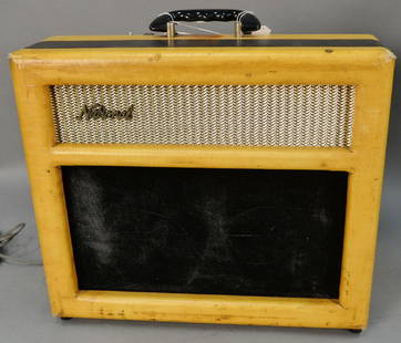
Sold20171960 National Tremo-Tone guitar amp along with original1960 National Tremo-Tone guitar amp along with original case.See Sold Price
Sold2022Excellent map of the U. S. from Gray’s National AtlasFirst time offered. Large, impressive and highly detailed map of the United States with full, original hand-coloring done at the time of publishing. This double-age map includes two inset maps of AlasSee Sold Price
Sold2024( 19th c )THE NATIONAL ATLAS OF HISTORICAL, COMMERCIAL, AND POLITICAL GEOGRAPHY. Wonderful maps,( 19th c )THE NATIONAL ATLAS OF HISTORICAL, COMMERCIAL, AND POLITICAL GEOGRAPHY. Wonderful maps, complete, EDINBURGH. Wear to covers, inside is overall nice condition.See Sold Price
Sold2023Map of N. Carolina from Gray’s National Atlas, 1875Map of North Carolina from the exceedingly scarce Gray’s National Atlas. Uncommon format highlighting North Carolina on its own (it’s usually paired with South Carolina). Topographical features arSee Sold Price
Sold2023Scarce RR map of Iowa from Gray’s National AtlasGray’s New Map of Iowa by Frank A. Gray. Copyright 1877 by O. W. Gray and found in a copy of Gray’s scarce 1884 National Atlas. Shows great detail, with railroads towns, rivers and other iSee Sold Price
Sold2023Scarce RR map of Utah from Gray’s National AtlasGray’s New Map of Utah by Frank A. Gray. From a scarce 1884 edition of Gray’s National Atlas. Shows Indian reservations, deserts, railroads, topography. Clean with a 1.5” tear at topSee Sold Price
Sold2018Strange Tales #77 (Oct 1960, Atlas) Kirby/DitkoFair/Good 1.5 Heavy spine wear with multiple tears. Heavy creasing on cover. Cover is loose. Off-white to white pages. Jack Kirby and Steve Ditko art.See Sold Price
Sold2018Strange Tales #77 Comic (Oct 1960, Atlas) Kirby/DitkoGood- 1.8 One inch spine split at bottom. Heavy spine wear including staple tears and stress lines with color break. Writing in pen on cover. Light cream to off-white pages. Jack Kirby and Steve DitkoSee Sold Price
Sold20165 Nice 1970's National Geographics with ArchaeologyNice selection from the 1970's featuring articles on the Minoans, Indians of Brazil, American Indians, Incas, and Stone Age Cultures! Great reads.See Sold Price
Sold2021Lot of 1980's & 90's National Geographics MagazinesLot of 1980's & 90's National Geographics MagazinesSee Sold Price
Sold20165 National Geographics 'Cowboys & IndiansHistorical theme covering cowboys, indians, Precolumbian cultures, and the Oregon Trail. Good reading!See Sold Price
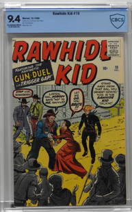
Sold2018Atlas Marvel Comics Rawhide Kid #19 CBCS 9.4United States,1960 Atlas Comics Rawhide Kid issue 19 from December, 1960. The book featured the first appearance of Susan Clark and Big Bill Corbett. When compared to the CGC census this book is the hSee Sold Price
Sold2019Johnston's Atlas 1843 with 41 double-page mapsHeading: Author: Johnston, Alexander Keith Title: The National Atlas of Historical, Commercial and Political Geography, constructed from the most Recent and Authentic Sources Place Published: EdinburSee Sold Price
Sold2021Early atlas map of Louisville, Ky. By O.W. GrayClean and fine map of Louisville, Kentucky from the first edition of Gray’s National Atlas. Maps of Louisville in early atlases were usually joined with another city on the page. This 1875 example dSee Sold Price
Sold20221875 Gray's New Map of Texas - 1st ed.Large and impressive hand-colored map of Texas from Gray’s National Atlas. Full title: “Gray’s New Map of Texas and the Indian Territory.” Created by Frank Gray, the map hasSee Sold Price
Sold2023Large Lot of 1950-60's Boy Scouts Of America Patches & MoreLot includes 17 printed bandanas, some with sewn on patches, seven bolo slides, one printed T-shirt from 1964 National Jamboree, one leather patch from 1960 National Jamboree, and BSA green short sleeSee Sold Price
Sold20231833 ATLAS MAPS Cartography Navigation Voyages Illustrated French Petit Monin1833 ATLAS MAPS Cartography Navigation Voyages Illustrated French Petit Monin This incredible printing of Petit National Atlas features 96 impressive maps of world countries and islands, as well as FrSee Sold Price
Sold2018New York City, Brooklyn, Jersey City, Hoboken Etc.Title: New York City, Brooklyn, Jersey City, Hoboken Etc. Date: 1883 Cartographer: COLTON, GEORGE WOOLWORTH Size: 24.5 X 16.3 42-43 from Gray's The National Atlas... Special edition for Pennsylvania.See Sold Price
Sold2023Authentic 1875 map of Palestine, O. W. GrayMap of Palestine or the Holy Land from an 1875 National Atlas by O. W. Gray. Full original hand coloring. Inset: Arabia Petraea. “Land of the Philistines” shown at lower left of map. VerySee Sold Price
Sold2022Excellent antique map of Vermont from scarce Gray’s Nat’l AtlasJ. H. Colton 1855 map of Vermont, republished in the very scarce 1884 edition of Gray’s National Atlas. The ornamental border was dropped when it was republished. Shows railroads, post offices,See Sold Price
4 days LeftMynt AuctionsJuan Marichal 1960 Rookie Playing Days Signed National League Baseball JSA COAUS$210
Jun 30JM Hobby Supply and Railroad Artifact AuctionsSet of Four Mixed Non-Running Diesel Locos-MILW/ATSF/AMTRAK/CNUS$20(1 bid)
4 days LeftThe Bidder AuctionsOrig. Press Photo of Josip Broz Tito PM and president of the Socialist Federal Republic ofUS$35
Jun 20The Ross Art GroupOriginal Vintage Fly TWA Jets India Pink Elephant Poster by David Klein c1960US$600(1 bid)