Sold201619thc Civil War Map, Invasion of PennsylvaniaOriginal 19th Century Map, Page from "Harper's Pictorial History Of The Civil War." Shows Pennsylvania, Maryland ,Virginia & Delaware. Gettysburg, Philadelphia & Washington. June, 1863. Approx 10" X 1See Sold Price
Sold202319thc Civil War Map of The Campaign In Virginia19th Century map of the Civil War Campaign in Virginia, from an August 1862 edition of "The Soldier In Our Civil War". Approx 5" X 8".See Sold Price
Sold2022Scarce Civil War era map of Florida with great detail,Great map of Florida showing the entire state (includes small inset of Florida Keys). Shows state shortly after the outbreak of the Civil War. Notes proposed course of a canal route from Tampa to theSee Sold Price
Sold2023Civil War era map of Florida, 1863Lovely early map of Florida, vividly hand colored by county, with a large inset of the Florida Keys. Shows towns, railroads, villages, post offices, forts, etc. Only five counties shown in the southerSee Sold Price
Sold202419th C. Johnson’s Florida Map1863 Civil War era colored map of Florida by Alvin Jewett Johnson, published by A.J Johnson New York. Unframed in protective sleeve. Measures just shy of 14 inches by 18 inches.See Sold Price
Sold2023FRAMED 19TH C. JOHNSON'S FLORIDA MAP1863 Civil War Era Colored Map of Florida, by Alvin Jewett Johnson (1827-1884), published by Johnson & Ward, New York, in a gilded and green painted wooden frame with mat, glazed, OS: 19 1/2" x 23 1/2See Sold Price
Sold2019Civil War Atlas, "General Topographic Map, Ga.,Civil War Atlas, "General Topographic Map, Ga., Florida," Plate 145, H. - 18 1/2 in., W. - 29 1/2 in.See Sold Price
Sold2022Rare Seat of War 1862 Civil War pocket mapVery desirable and scarce large map of the Civil War issued during the early part of the war. Includes Virginia, Maryland and the Chesapeake Bay along with parts of other states. Depicts the entire EaSee Sold Price
20231859 Map of Florida by ColtonTitle: 1859 Map of Florida by Colton Date/Period: 1859 Materials: Steel engraved Size: 17 1/2 x 14 1/2” Florida with Florida keys in the insert. From before the civil war. By J. H. Colton & G. WSee Sold Price
Sold2023Nice 1865 map of Florida from Johnson and WardJohnson’s Florida dated 1863 and published in the last year of the Civil War with entire lower part of the state undeveloped. Johnsons New Illustrated Family Atlas began its publishing history iSee Sold Price
Sold20231859 Map of Florida by ColtonTitle: 1859 Map of Florida by Colton1859 Materials: Steel engraved Size: 17 1/2 x 14 1/2” Florida with Florida keys in the insert. From before the civil war. By J. H. Colton & G. W. Colton. From "GeSee Sold Price
Sold2023Nice 1865 map of Florida from Johnson and WardJohnson’s Florida published in the last year of the Civil War and showing entire lower part of the state as undeveloped. Johnsons New Illustrated Family Atlas began its publishing history in 1860 anSee Sold Price
Sold2017Johnson’s 1862 map of Florida with wide marginsScarce map offers a wonderful snapshot of this secessionist state shortly following the outbreak of the American Civil War. Sharp example of the first Johnson & Ward map of Florida. The Johnson FamilySee Sold Price
Sold2017Bellin: Antique Plan of Pensacola Bay in Florida, 1764Map: Plan de la Baye de Pensacola dans la Floride Cartographer: Bellin Place & Date: Paris / 1764 Size: 6 1/2" x 8 1/8" Condition: outline color; light overall age toning; a few minor spots in marginsSee Sold Price
Sold2018Two Civil War Era Mitchell MapsMap of North America Showing Its Political Divisions and county maps of North Carolina, South Carolina, and Florida on one sheet (Philadelphia: S. Augustus Mitchell, 1860). Not framed. 15.25 x 12.25 iSee Sold Price
Sold2019U S Coast Survey 1896 LG Map. Gulf Coast. Florida, MI"Sketch Showing Progress of Surveys on the Gulf Coast Lake Pontchartrain Mobile and Pensacola Bays" Detailed map showing New Orleans to Santa Rosa Sound, with inset showing Tortugas Harbor. Large LithSee Sold Price
Sold2021(CIVIL WAR.) U.S. Coast Survey; Nicholson, Walter L.(CIVIL WAR.) U.S. Coast Survey; Nicholson, Walter L. (compiler.) Map of Eastern Virginia. Chromolithographed map of Virginia from the Chesapeake Bay to Lexington. 26x21 inches sheet size, wide marginsSee Sold Price
Sold2022Vintage RR map of Maryland & Delaware, 1850Excellent 1850 map of Maryland and Delaware with a chart of Chesapeake Bay Steamboat Routes. Published a decade before the Civil War and during an explosion in the country's railroad routes, the map aSee Sold Price
Sold2022Late 19thc United States Military Campaign MapInteresting late 19th Century fold out, miltary campaign map of The United States during The Civil War, Battle of Antietam, by Hugh Rees, Ltd. Plan No. 13. Map pinpoints - West Point, Charleston, NewSee Sold Price
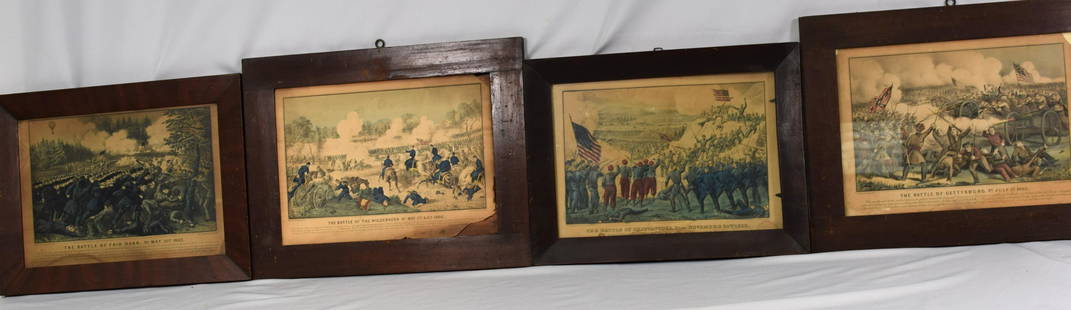
Sold202119THC CIVIL WAR HAND COLORED LITHOGRAPHSLot of 4 19thc Civil War hand colored lithographs by Currier and Ives in original frames,3 with glass.. Entitled The Battle of Chattanooga,Tn November 24th 1863,The Battle of Gettysburg PaJuly 3rd 186See Sold Price
Sold20241892 Cowles Civil War Map of Battles in Gettysburg, Virginia, W Virginia and Maryland -- Sketch ofTitle: 1892 Cowles Civil War Map of Battles in Gettysburg, Virginia, W Virginia and Maryland -- Sketch of the battle of McDowell, VA. [and] Route Map of Gettysburg Campaign Lt-Gen T.J. Jackson [and] SSee Sold Price
Sold2017Civil War Map of America June 30, 1861Framed Civil War Map of America from June 30, 1861 showing the boundaries of the Union and Confederate Geographical Divisions and Departments. It also features a gold plaque with the description. ThisSee Sold Price
Sold202419thc Civil War Engraving, Confederate Ship CSS Alabama19th Century Civil War engraving, a double page from an edition of The Soldier In Our Civil War. Hold Of The Confederate Privateer "Alabama". Captain Semmes, In Which Were Confined The Officers And CrSee Sold Price
Sold2016Civil War Map of Secessionville, James IslandTitle: Map of the Engagement At Secessionville James Island, S.C. June 16, 1862 Maker: Washington Government Printing Office Date:1892 Civil War Map showing Union and Confederate troop locations and mSee Sold Price
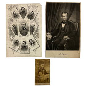
Jun 22Lakeshore Event CenterEphemera, Civil War Generals, Abraham Lincoln, Ulysses Grant, Lot of 3US$30(1 bid)
Jun 23Schilb Antiquarian Rare Books1918 Robert E Lee Civil WAR Confederate General CSA Battles MAPS IllustratedUS$9(3 bids)
Jun 28South Florida Auction & Estate Sale Services IncCivil War Abraham Lincoln Tin Type PhotographUS$6(1 bid)
Jun 23Schilb Antiquarian Rare Books1890 1ed Confederate Memoirs of Joseph Johnston & Jefferson Davis Civil War CSAUS$66(3 bids)
4 days LeftHolabird Western Americana CollectionsJefferson Davis Confederate Stamp Sheet, Scott 11 [179366]US$750
4 days LeftEarly American History Auctions1863 JOHN ARCHIBALD CAMPBELL ALS Re: a Friends Prisoner Exchange Confederate Asst. Secretary of WarUS$450
4 days LeftEarly American History Auctions1905 Civil War General OLIVER OTIS HOWARD Typed Letter Signed as President of the Lincoln MemorialUS$300
2 days LeftWeatherham Estate TreasuresAbraham Lincoln Bronze Bust Sculpture On Marble Base - Signed Original - 10lbsUS$400
Jun 13Swann Auction Galleries(CIVIL WAR.) [Charles Magnus]. [One Hundred Miles Around Richmond].US$500
4 hrs LeftJasper521854-5 Parke Profile Maps of California, Arizona and New Mexico -- Profiles from San Francisco BayUS$55
4 hrs LeftJasper521893 Civil War Map of Siege of Yorktown, Battle of Siloh and Army of Ohio Operations -- Plan ofUS$55
4 hrs LeftJasper521893 Civil War Map of Knoxville Area -- Topographical Map of the Approaches and Defences ofUS$70
4 hrs LeftJasper521893 Civil War Map Washington, Paducah, KY and Logan's Cross-Roads plus Mill Springs, KY -- DefensesUS$70
4 hrs LeftJasper521893 Civil War Map of Yorktown -- Secession Works at Yorktown [with] The Position of Yorktown withUS$55
4 days LeftSimpson Galleries, LLC.JULIUS BIEN (1826-1909) AN AMERICAN CIVIL WAR RECONNAISSANCE MAP, "Map of Texas and Part of NewUS$100
Jun 28South Florida Auction & Estate Sale Services IncABRAHAM LINCOLN Memorial Belt Buckle Approved by MRS. LINCOLNUS$6(1 bid)
4 hrs LeftJasper521853 Williamson Map of Tejon Pass, California -- Map and Profile of the Tejon Pass from explorationsUS$55


![1892 Cowles Civil War Map of Battles in Gettysburg, Virginia, W Virginia and Maryland -- Sketch of: Title: 1892 Cowles Civil War Map of Battles in Gettysburg, Virginia, W Virginia and Maryland -- Sketch of the battle of McDowell, VA. [and] Route Map of Gettysburg Campaign Lt-Gen T.J. Jackson [and] S](https://p1.liveauctioneers.com/5584/329422/177662185_1_x.jpg?height=310&quality=70&version=1715717898)


![Jefferson Davis Confederate Stamp Sheet, Scott 11 [179366] (1 of 1)](https://p1.liveauctioneers.com/2699/331499/178846702_1_x.jpg?height=282&quality=70&version=1717095214)


![(CIVIL WAR.) [Charles Magnus]. [One Hundred Miles Around Richmond]. (1 of 1)](https://p1.liveauctioneers.com/199/332329/179231616_1_x.jpg?height=282&quality=70&version=1717450360)


![1893 Civil War Map of Yorktown -- Secession Works at Yorktown [with] The Position of Yorktown with (1 of 1)](https://p1.liveauctioneers.com/5584/331064/178466378_1_x.jpg?height=282&quality=70&version=1716924723)


