Sold2019AN ANTIQUE MAP, "Poli Arctici et CircumiacentiumAN ANTIQUE MAP, "Poli Arctici et Circumiacentium Terrarum Descriptio Novissima," CIRCA 1676, hand colored engraving on paper, published by Frederick de Wit (1630-1706), a banner cartouche U/L, "GedrucSee Sold Price
Sold2019AN ANTIQUE MAP, "Accuratissima Angliæ Regni et WalliæAN ANTIQUE MAP, "Accuratissima Angliæ Regni et Walliæ Principatus," AMSTERDAM, CIRCA 1680, hand colored engraving on paper, published by Frederick de Wit (1630-1706), showing most of the British IslSee Sold Price
Sold2023De Wit Map of Zeeland, HollandDE WIT, Frederick (c. 1630-1706). Comitatus Zelandiae tabula... Engraved map with original hand color. Amsterdam, c. 1680. 21 1/2" x 24 3/8" sheet, approx. Antique Map of Zeeland, Netherlands showingSee Sold Price
Sold2020WIT, FREDERICK de. Novissima et Accuratissima TotiusWIT, FREDERICK de. Novissima et Accuratissima Totius Americae Descriptio. Double-page engraved map of the Americas showing California as an island. 20x23½ inches sheet size, ample margins; originSee Sold Price
Sold2022De Wit - Nova Orbis Tabula In Lucem Edita, MapFrederick De Wit (circa 1629-1706), Nova Orbis Tabula In Lucem Edita, A.F. De Wit, published by Covens and Mortier, Amsterdam, circa 1720, in two sheets, engraving on laid paper, double hemisphere vieSee Sold Price
Sold2022De Wit, Map of North and South America, c. 1720Property of a Private Collector, Hilton Head Island, SC Description: Frederick De Wit (circa 1629-1706), Nova Orbis Tabula In Lucem Edita, A.F. De Wit, Amsterdam: Covens and Mortier, c. 1720, publSee Sold Price
Sold2022MAP, Middle East, WitMiddle East. Frederick de Wit, Nova Persiae Armeniae Natoliae et Arabiae, 1680 (circa). Hand Color. This splendid map of the Middle East covers the region from Turkey and Egypt to Afghanistan with theSee Sold Price
Sold2022MAP, South America, WitNorthwestern South America & Central America. Frederick de Wit, Novae Hispaniae, Chili, Peruviae, et Guatimalae Littorae, from Orbis Maritimus ofte Zee Atlas, 1680 (circa). Hand Color. This handsome sSee Sold Price
Sold202017th c Map of China- F. De WitChina.- De Wit (Frederick) Magn‘ Tartari‘, Magni Mogolis Imperii Japon‘ et Chin‘, nova descriptio, China and Tartary with Japan, ornamental cartouche, engraved map with hand-coSee Sold Price
Sold2017de Wit: Antique Map of Portugal & Parts of Spain, 1690Title/Content of Map: 1690 de Wit Map of Portugal and Parts of Spain -- Tabula Portugalliae et Algarbia Date Printed: 1690, Amsterdam Cartographer: F de Wit Size: 18.5 x 22.2 in. Condition: Good. ExceSee Sold Price
Sold2022MAP- Frederick De. Wit:MAP- Frederick De. Wit: MAP- Frederick De. Wit: NOVISSIMA PRAE CETERISALIIS ACCURATISSIMA REGNORUM ANGLIAE SCOTIAE HIBERNIAE. Ca. 1690, hand coloured and laid down (560x490mm)See Sold Price
Sold2017[MAP] FREDERICK DE WIT (DUTCH, 1630-1706)Map of Frankfurt in Hesse, Germany, c. 1680See Sold Price
Sold2017[MAP] FREDERICK DE WIT (DUTCH, 1630-1706)Map of the Archbishopric Treves, Germany, c. 1680See Sold Price
Sold2017[MAP] FREDERICK DE WIT (DUTCH, 1630-1706)Map of North Rhine-Westphalia, Germany, c. 1680See Sold Price
Sold2017[MAP] FREDERICK DE WIT (DUTCH, 1630-1706)Map of Cologne and the Lower Rhine Region, Germany, c. 1690See Sold Price
Sold2023Antique Map of England - 1670F. De Wit Antique Print 1670 - Amsterdam Map of England Image Size: 23.5 x 20 in. Overall Framed Size: 33 x 28.75 in. Framed behind glass.See Sold Price
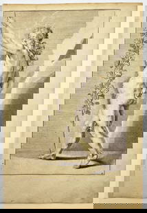
Sold2023Antique Engraving - Frederick de Wit - Female Form - Drawing of Woman FigureTitle/Artist: Antique Engraving - Frederick de Wit - Female Form - Drawing of Woman Figure Medium: Antique engraving originates from "Lumen Picturae: A Classical Drawing Manual" by Frederick de Wit. TSee Sold Price
Sold2017de l’Isle / Buache: Antique Map of the Americas, 1790Map: Carte d'Amerique, Dressee pour l'instruction Cartographer: Guillaume De l'Isle / Philippe Buache / J. A. Dezauche Place & Date: Paris / 1790 Size: 23 1/2 x 18 1/2" Condition: outline and wash colSee Sold Price
5 days LeftTrillium Antique Prints & Rare BooksPrevost - Map of the South Pacific Ocean with New Holland (Australia), New Zealand, and part of theUS$50(1 bid)
5 days LeftTrillium Antique Prints & Rare BooksPrevost - Map of Japan with part of Korea and ChinaUS$50
5 days LeftTrillium Antique Prints & Rare BooksPrevost - Map of the Philippines, Celebes, MoluccasUS$50
5 days LeftTrillium Antique Prints & Rare BooksPrevost - Pair of Engravings of Views of Acapulco, MexicoUS$50
5 days LeftTrillium Antique Prints & Rare BooksPrevost - Chart of the Bay of Bengal, Indian OceanUS$50
5 days LeftTrillium Antique Prints & Rare BooksPtolemy & Magini, pub. 1620 - Map of the British Isles (Britain, Scotland, Ireland)US$50
5 days LeftTrillium Antique Prints & Rare BooksBonne - Pair of Maps (Eastern & Northern Hemisphere)US$75
5 days LeftTrillium Antique Prints & Rare BooksPtolemy & Magini, pub. 1620 - Map of Tuscany, ItalyUS$50
5 days LeftTrillium Antique Prints & Rare BooksPtolemy & Magini, pub. 1620 - 4 Maps of Parts of AsiaUS$50
Featured2 days LeftJasper52Carte du Golfe du Mexique et des Isles de l'Amerique' Caribbean BELLIN 1754 mapUS$200
2 days LeftJasper52Carte de l'Isle de St Christophle'. St Christopher / St Kitts. BELLIN 1759 mapUS$85
2 days LeftJasper52Cartes de supplément pour les Isles Antilles. West Indies Islands BONNE 1790 mapUS$40


![[MAP] FREDERICK DE WIT (DUTCH, 1630-1706): Map of Frankfurt in Hesse, Germany, c. 1680](https://p1.liveauctioneers.com/3820/102962/52635987_1_x.jpg?height=310&quality=70&version=1492789342)
![[MAP] FREDERICK DE WIT (DUTCH, 1630-1706): Circulus Bavaricus](https://p1.liveauctioneers.com/3820/102962/52635903_1_x.jpg?height=310&quality=70&version=1492789342)
![[MAP] FREDERICK DE WIT (DUTCH, 1630-1706): Totius Flumenis Rheni Novissima](https://p1.liveauctioneers.com/3820/102962/52635922_1_x.jpg?height=310&quality=70&version=1492789342)
![[MAP] FREDERICK DE WIT (DUTCH, 1630-1706): Map Lower Saxony, Germany](https://p1.liveauctioneers.com/3820/102962/52635937_1_x.jpg?height=310&quality=70&version=1492789342)
![[MAP] FREDERICK DE WIT (DUTCH, 1630-1706): Electoratus et Palatinatus Rheni](https://p1.liveauctioneers.com/3820/102962/52635902_1_x.jpg?height=310&quality=70&version=1492789342)
![[MAP] FREDERICK DE WIT (DUTCH, 1630-1706): Map of the Alsace, Germany, c. 1680](https://p1.liveauctioneers.com/3820/102962/52635901_1_x.jpg?height=310&quality=70&version=1492789342)
![[MAP] FREDERICK DE WIT (DUTCH, 1630-1706): Map of the Archbishopric Treves, Germany, c. 1680](https://p1.liveauctioneers.com/3820/102962/52635920_1_x.jpg?height=310&quality=70&version=1492789342)
![[MAP] FREDERICK DE WIT (DUTCH, 1630-1706): Map of North Rhine-Westphalia, Germany, c. 1680](https://p1.liveauctioneers.com/3820/102962/52635921_1_x.jpg?height=310&quality=70&version=1492789342)
![[MAP] FREDERICK DE WIT (DUTCH, 1630-1706): Map of Cologne and the Lower Rhine Region, Germany, c. 1690](https://p1.liveauctioneers.com/3820/102962/52635857_1_x.jpg?height=310&quality=70&version=1492789342)
![[MAP] FREDERICK DE WIT (DUTCH, 1630-1706): Circulus Franconicus](https://p1.liveauctioneers.com/3820/102962/52635856_1_x.jpg?height=310&quality=70&version=1492789342)