Sold20211628 Munster Map of Africa -- Africae Tabula NovaTitle: 1628 Munster Map of Africa -- Africae Tabula Nova Cartographer: S Munster Year/Place: 1628, Petri Map Dimensions (in.): 12.1 X 14.2 in. Description: This is a superb double-page woodblock map oSee Sold Price
Sold20221598 Munster Map of Africa -- [Africa]Title: 1598 Munster Map of Africa -- [Africa] Cartographer: S Munster Year/Place1598 c., Basel Dimensions: 5 X 6.1 in. Description: This is an excellent woodblock map of most of Africa. It shows the NSee Sold Price
Sold2016Greek terracotta head of a woman, North AfricaA Greek terracotta head of a woman, North Africa, Libya, c. 4th - 1st Century BC, with detailed features, her hair styled into a coiled plait behind a diadem. 2 1/8 in x 1 1/2 in (5.4 x 3.8 cm). LightSee Sold Price
Sold2024NORTH EAST AFRICA. Libya Egypt Sudan Ethiopia Ubangi-Shari Chad 1952 old mapCAPTION PRINTED BELOW PICTURE: 'Africa, North-East' DATE PRINTED: 1952 IMAGE SIZE: Approx 34.0 x 44.0cm, 13.5 x 17.25 inches (Large); Please note that this is a folding map. TYPE: Vintage colour map;See Sold Price
Sold2023NORTH EAST AFRICA. Libya Egypt Sudan Ethiopia Ubangi-Shari Chad 1952 old mapTITLE/CONTENT OF MAP: 'Africa, North-East' DATE PRINTED: 1952 IMAGE SIZE: Approx 34.0 x 44.0cm, 13.5 x 17.25 inches (Large); Please note that this is a folding map. TYPE: Vintage colour map; Scale 1:1See Sold Price
Sold2019Maps 19th Cent. Mixed Lot of 9Incl France, British Isles, Holland/Belgium, North Pole, Chile, Buckinghamshire, India, Africa/Libya, and Switzerland. Paper Size: Up to 23 x 18.5 inch (59 x 47cm) Most with small faultsSee Sold Price
Sold2022Jewish Terracotta Shabbat Candlestick, North AfricaTerracotta Shabbat candlestick, North Africa, probably Libya, 19th century. Decorated with geometric patterns in black on a yellow and red background. Height: 35 cm, width: 20 cm.See similar item: SotSee Sold Price
Sold20161796 Map Africa PropriaANTIQUE MAP “AFRICA PROPRIA” CARTGAHE LIBYA, TRIPOLI, MALTA, BY CELLARIUS 1796. From: Geographia Antiqua London. Very Good, measures 15 x 10”, central fold. No Reserve Free shipping for this iteSee Sold Price
Sold2023NORTH AFRICA BARBARY. Tripoli Libya Egypt coast Alexandria Tobruk. SDUK 1874 mapTITLE/CONTENT OF MAP: 'NORTH AFRICA OR BARBARY, V., PARTS OF TRIPOLI AND EGYPT' DATE PRINTED: 1874 IMAGE SIZE: Approx 34.0 x 42.5cm, 13.25 x 16.75 inches (Large) TYPE: Antique steel engraved map withSee Sold Price
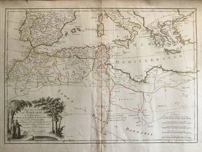
Sold20241837. Map of Barbary Coast. Northwest Africa. Morocco, Algeria, Libya and Tunisia. By A. PerrotTitle: 1837. Map of Barbary Coast. Northwest Africa. Morocco, Algeria, Libya and Tunisia. By A. Perrot Date/Period: 1837 Materials: Hand-colored steel engraving Size: 7 x 10 3/4” This is a map oSee Sold Price
Sold2020Lot of 10 Coins Libya Tunisia South Africa 1914-1952Whether you are a seasoned collector or new to numismatics, there is something here for you! This auction includes over 1000 lots that have been in storage and untouched for 40 years. All coins are soSee Sold Price
Sold2020Barbary coat. North west Africa. Morocco, Tunisia,Title: Barbary coat. North west Africa. Morocco, Tunisia, Algeria and Libya.. Date/Period: 1762 - 1771 Materials: Copperplate engraved Size: 20”x 14 1/2”. Barbary coast, shows North African countrSee Sold Price
Sold2018Memorial head of an "oba" - Nigeria, Beninwood, collection number "14", base H: 34,5 cm, H: 13,6 inch Provenance: Emil Storrer, Zurich, Switzerland Zemanek-Münster, Würzburg, 30 November 2013, lot 319 Continent: AfricaSee Sold Price
Sold2022(LIBYA / TUNISIA.) Gerard Mercator. Africae Tabula Secunda.(LIBYA / TUNISIA.) Gerard Mercator. Africae Tabula Secunda. Double-page engraved Ptolemaic map of the eastern Maghreb region of Africa and the central Mediterranean Sea. 16½x20½ inches sheetSee Sold Price
Sold2018Sanson: North Africa / Patriarchate of Alexandria, 1730Partriarchatus Alexandrini Geographica descriptio The later Covens & Mortier edition of Sanson's map of the Patriarchate of Alexandria encompassing Libya and Egypt, with great detail and many place naSee Sold Price
Sold20186Pcs Africa Indonesia Collectibles GIFTS TO AMERICANDetails: 6Pcs Africa Indonesia Collectibles GIFTS TO AMERICAN GOVERNMENT OFFICIAL & SOUVENIRS Kenyan Military Statue Indonesian Military Plaque African Rungu Libya Sabratha These six pieces were eithSee Sold Price
Sold20181817 Mavor Travels Egypt North Africa“A Selection from Dr. Wm. Mavor’s Celebrated Voyages, Travels…”, printed at Philadelphia by Morgan and Yeagar (c1817). Travels to Egypt and Libya by Browne and Sonnini, 237 pages. Binding withSee Sold Price
Sold2022MUNSTER, SEBASTIAN Tabula Britanniae. [Basel: circa 1571]. Woodcut map on laid paper set with aMUNSTER, SEBASTIAN Tabula Britanniae. [Basel: circa 1571]. Woodcut map on laid paper set with a trapezoidal border, paginated 120/121, with signature mark k5 to lower corner, Latin text on verso. SheeSee Sold Price
Sold2016Toscana - [Munster, Sebastian]Florenz. Figur und gelegenheit der edlen und Hochberuehmbten Statt FlorentzSee Sold Price
Sold2020Munster, Sebastian C1580 Early Woodcut. HistoricalWoodcut Published 1544-1628 for the "Cosmographia" by Sebastian Munster. Printed both sides. Paper Size: Up to 14 x 9 inch (37 x 23cm) Some toning. Bottom margin tear.See Sold Price
Sold20241598 COSMOGRAPHY by Sebastian Munster antique RARE ILLUSTRATED w/ MAPS PIGSKINMUNSTER, Sebastian (1489-1552). Cosmographey, das ist, Beschreibung aller Länder, Herrschafften und fürnemesten Stetten des gantzen Erdbodens Cosmography: that is, description of all countries... BaSee Sold Price
Sold2024MÜNSTER. Cosmographey.MÜNSTER, Sebastian. Cosmographey. Oder beschreibung aller Länder... des gantzen Erdbodens. Basel, S. Henricpetri, 1592Folio. 355x255 mm. Legatura del XVII secolo in vitello, fregi in oro alSee Sold Price
Sold2015Munster. TABULA NOVARUM INSULARUM... [c. 1558-59.][Munster, Sebastian] TABULA NOVARUM INSULARUM, QUAS DIVERSIS RESPECTIBUS OCCIDENTALES & INDIANAS UOCANT. Double-page woodcut map of North and South America by Sebastian Munster. First cut in 1540, thiSee Sold Price
Sold2020MÜNSTER, SEBASTIAN. Die Erst General Tafel / DieMÜNSTER, SEBASTIAN. Die Erst General Tafel / Die Beschreibung und den Circkel des Gantzen Erdtrichs und Deers Innhaltende. Double-page woodcut map of the world within a foliate border design. 14xSee Sold Price
1 day LeftL'Autographe LtdMUSIC - Opera singers/1 - Lot of concert programs and signed photographs£150
May 16Potter & Potter AuctionsLANGENECKERT. It’s A Dog’s World. 1968. St. Louis: Ralston ...US$100
1 day LeftMynt Auctions2004 South Africa Natura Series - Wild Cats of Africa: Caracal 3 Coin Gold SetUS$2,300
1 day LeftMynt Auctions1964 Johannesburg South Africa First Flight Airmail Cover FFC To MadagascarUS$400
May 06Art Legacy AuctionsRare and unique marble sculpture heads, Ruins of Carthage. 1st century after Christ OutstandingUS$1,600
May 11Art Legacy AuctionsRare and unique marble sculpture heads, Ruins of Carthage. 1st century after Christ OutstandingUS$1,600
May 12Schilb Antiquarian Rare Books1869 ATLAS 42 MAPS America Africa Australia GERMANY Switzerland Sydow RAREUS$130(3 bids)
May 12Schilb Antiquarian Rare Books1859 AFRICA VOYAGES Barth Timbuktu Tripoli SLAVES Illustrated Slavery MAP AfricanUS$62(4 bids)
6 days LeftTremont AuctionsShelagh Price. South Africa. Large African village landscape painting with figures. Oil on canvas.US$150


![1598 Munster Map of Africa -- [Africa]: Title: 1598 Munster Map of Africa -- [Africa] Cartographer: S Munster Year/Place1598 c., Basel Dimensions: 5 X 6.1 in. Description: This is an excellent woodblock map of most of Africa. It shows the N](https://p1.liveauctioneers.com/5584/247177/128172960_1_x.jpg?height=310&quality=70&version=1652216088)


![MUNSTER, SEBASTIAN Tabula Britanniae. [Basel: circa 1571]. Woodcut map on laid paper set with a: MUNSTER, SEBASTIAN Tabula Britanniae. [Basel: circa 1571]. Woodcut map on laid paper set with a trapezoidal border, paginated 120/121, with signature mark k5 to lower corner, Latin text on verso. Shee](https://p1.liveauctioneers.com/292/250642/130213678_1_x.jpg?height=310&quality=70&version=1654271664)
![Toscana - [Munster, Sebastian]: Florenz. Figur und gelegenheit der edlen und Hochberuehmbten Statt Florentz](https://p1.liveauctioneers.com/676/90372/46156023_1_x.jpg?height=310&quality=70&version=1466610731)


![Munster. TABULA NOVARUM INSULARUM... [c. 1558-59.]: [Munster, Sebastian] TABULA NOVARUM INSULARUM, QUAS DIVERSIS RESPECTIBUS OCCIDENTALES & INDIANAS UOCANT. Double-page woodcut map of North and South America by Sebastian Munster. First cut in 1540, thi](https://p1.liveauctioneers.com/179/82189/42599755_1_x.jpg?height=310&quality=70&version=1447864785)


![[MAP - TOURS] (1 of 1)](https://p1.liveauctioneers.com/292/326828/175962850_1_x.jpg?height=282&quality=70&version=1713473479)


