Sold2019AFRICA. Shows Mountains of Kong/the Moon. CaravanTITLE/CONTENT OF MAP: 'Africa' The map shows a number of tribal and early colonial territories, mostly delineated inland from the coast but with unresolved borders. The Maghreb is described evocativelSee Sold Price
Sold2019AFRICA. Shows Mountains of Kong/the Moon. CaravanTITLE/CONTENT OF MAP: 'Africa' The map shows a number of tribal and early colonial territories, mostly delineated inland from the coast but with unresolved borders. The Maghreb is described evocativelSee Sold Price
Sold2024Pre-colonial Africa. Mountains of Kong/Moon. Caravan routes. THOMSON 1817 mapTITLE/CONTENT OF MAP: 'Africa' This wonderful large map shows Africa at the start of the colonial era, when it was still substantially unexplored by Europeans. The substantial blank area in the centreSee Sold Price
Sold2024Pre-colonial Africa. Mountains of Kong/Moon. Caravan routes. THOMSON 1817 mapTITLE/CONTENT OF MAP: 'Africa' This wonderful large map shows Africa at the start of the colonial era, when it was still substantially unexplored by Europeans. The substantial blank area in the centreSee Sold Price
Sold2020Ortelius Map of Africa 1570Abraham Ortelius (1527-1598), "Africae Tabula Nova," Antwerp, 1570. This hand colored map of Africa originates from Ortelius' "Theatrum Orbis Terrarum." The map shows political divisions within AfricaSee Sold Price
Sold2023Original Vintage Indochine Francaise Map by Lucien Boucher 1935 Vietnam Laos CambodiaAs one can only imagine, travel in the Far East in the 1920's must have been a challenging adventure. This well illustrated map poster by master artist, Lucien Boucher shows the various routes once coSee Sold Price
Sold2024Antique TC Lotter Magni Turcarum Dominatoris Map19.5 X 22.5 Antique map by famous German cartographer Tobias Conrad Lotter of the Turkish empire, Magni Turcus Dominatoris Imperium. Shows regions of Europe, Asia, and Africa. Original publication donSee Sold Price
Sold2022Rare 1836 Col. Dodge Expedition map - 1st printing, SteenLarge and important early copper engraved map of the western U. S. showing the route of Col. Henry Dodge’s 1835 Expedition from Fort Leavenworth to the Rocky Mountains. Rare first printing withSee Sold Price
Sold20219 Adirondack Mountain Maps & Pamphlets,1870-90'sCollection 1870s Adirondack Mountain Maps & Pamphlets. Includes the historic Preliminary Survey of the Adirondacks made by Verplanck Colvin in 1893, two "Birch Bark from the Adirondacks" books from 18See Sold Price
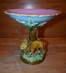
Sold2019Rare GEORGE JONES Majolica Centerpiece "Africa"Very Rare Majolica GEORGE JONES Centerpiece/Compote from the Continents Series, "Africa". It shows a Lion and Lioness under a tree with a Lizard hiding under a burrow. c. 1874 this is one of the fourSee Sold Price
Sold2019WorldTitle/Content of Map: World Date: 1493 Cartographer: Schedel Material/Medium: Woodblock engraving Size: 18x25” The oldest decorative world map that’s obtainable. Map shows 12 wind heads, shows theSee Sold Price
Sold2020Gastaldi Map of Africa*** START PRICE IS THE RESERVE *** [Africa]. GASTALDI, Giacomo (1500-1566) & FORLANI, Paolo (fl. 1560-1571). La Descrittione dell'Africa. Engraved Map. Venice: Paolo Forlani, 1562. 19 x 25 1/4 inchesSee Sold Price
Sold2022Météorite lunaire, spécimen complet Lunar Meteorite--Complete IndividualMétéorite lunaire, spécimen complet Lunar Meteorite--Complete Individual Moon rock – Lunar Achondrite (ALUN), Lunar feldspathic breccia Northwest Africa, Sahara Desert The Moon isSee Sold Price
Sold2021Large Fossilized Starfish & Sea Lily CrinoidsNorth Africa, Anti Atlas Mountains, Ktaoua formation, Ordovician, ca. 488 to 443 million years ago. A rare and concentrated natural stone matrix of starfish and crinoids (sea lilies) that died and fosSee Sold Price
Sold2015De Bry (Theodore) - Descriptio Hydrographicathe 2-sheet map of Africa and Asia, from the east coast of Brazil to Japan, charting the first Dutch voyage to the East Indies by Houtman, large titlecartouche upper centre of right sheet, ships, compSee Sold Price
Sold2020CHINESE QING RED DRAGON AND BLUE MOUNTAIN VASEMeasurements: 17-3/8" H x 8-7/8" Dia. Chinese Qing Dynasty Red Dragon and Blue Rocky Mountain motif porcelain moon vase, With Kangxi Reign Mark on underbase. PROVENANCE: Property of private collectionSee Sold Price
Sold2020Laurie & Whittle Map of AmericaLAURIE & WHITTLE (Late 18th Century)The United States of America...Engraved map with original hand color in full.London: Laurie & Whittle, 1794.20 1/4" x 22 1/2" sheet.The first British map to show thSee Sold Price
Sold2021Barney Bellinger Award Winning Adirondack Cabinet"Sunset Cabin" won Best of Show at The Blue Mountain Museum's Artisan Show in the early 2000's. It has been featured in Ralph Kylloes Book "Adirondack Home" on page 198 and 199. This two piece unit waSee Sold Price
Sold2017LOUIS XVI STYLE CLOCKC.1850, By Tiffany, Young Ellis N.Y., Ormolu With Porcelain Cupid Painted Decoration, Time & Strike, Shows Date, Month, Day And Moon Dial, 17"H. 12"W. 7"D.See Sold Price
Sold2015A FINE CHINESE CARVED WHITE JADE A MOUNTAIN LANDSCAPEChinese Carved White Jade a Mountain Landscape. The jade shows figures in a mountainous landscape in reliefs. The face depicting a rocky outcrop among scattered pavilions with pine trees and shrubs grSee Sold Price
Sold2016CARVED JADE MOUNTAIN BOULDER IN ORG BOXChinese Carved White Jade a Mountain Landscape. The jade shows group of elderly scholars in a mountainous landscape in reliefs. The face depicting a rocky outcrop among boulders in the mountain scene.See Sold Price
Sold2017CHINESE JADE A MOUNTAIN LANDSCAPE ON STANDChinese Carved Jade a mountain landscape. The jade shows an elderly sage seeking for Tao beneath a shading trees within mountainous landscape in reliefs. The face depicting a rocky outcrop among bouldSee Sold Price
Featured4 days LeftJasper52Northern Hemisphere / Projected on the Plane of the Horizon of LondonUS$120
Jun 27Rail & Road Auctions45 Peices of Western Railroad Paper Ephemera - Southern Pacific, Northern Pacific, Union Pacific,US$30(1 bid)
Featured4 days LeftJasper521863 Johnson's Chart of Comparative Heights of Mountains and Lengths of Rivers of Africa, Asia,US$110
Jul 06Case Antiques, Inc. Auctions & AppraisalsColton's Atlas of the World, 1856, in Two Volumes; plus Africa / Mahdist War MapUS$500
Jun 23Schilb Antiquarian Rare Books1890 Livingstone 1ed In Darkest Africa Henry Stanley Emin Pasha Expedition MAPUS$115(8 bids)
17 hrs LeftSimpson Galleries, LLC.JULIUS BIEN (1826-1909) AN AMERICAN CIVIL WAR RECONNAISSANCE MAP, "Map of Texas and Part of NewUS$100
17 hrs LeftSimpson Galleries, LLC.J.H. Young (1792-1870) AN AMERICAN FEDERAL PERIOD MAP, "Mitchell's Travellers Guide Through theUS$500
Jul 06Case Antiques, Inc. Auctions & Appraisals5 TVA Map Books incl. Tennessee & New York c. 1935-1950US$250
Jun 15Riverfront Auctions"Arx Carolina" hand-colored engraving by Arnold Montanus c. 1671US$100(1 bid)
368 Lots AwayFreeman's | Hindman[MORMONS]. MILLROY & HAYES (fl. 1899). Route of the Mormon Pioneers from Nauvoo to Great Salt Lake,US$300
Jun 23Schilb Antiquarian Rare Books1831 Northern Traveller Voyages to NIAGARA Falls Quebec Canada Illustrated MAPSUS$2(2 bids)
593 Lots AwayDan Morphy AuctionsTURNBULL'S GREEN MOUNTAIN ICE CREAM DOUBLE-SIDED PORCELAIN SIGN W/ MOUNTAIN GRAPHICUS$300
6 days LeftWestern Trading PostApproximately 300+ Carats Of Natural Blue Moon And Fox Turquoise CabochonsUS$100(1 bid)


![Gastaldi Map of Africa: *** START PRICE IS THE RESERVE *** [Africa]. GASTALDI, Giacomo (1500-1566) & FORLANI, Paolo (fl. 1560-1571). La Descrittione dell'Africa. Engraved Map. Venice: Paolo Forlani, 1562. 19 x 25 1/4 inches](https://p1.liveauctioneers.com/1968/163248/82424552_1_x.jpg?height=310&quality=70&version=1583340284)


![[MORMONS]. MILLROY & HAYES (fl. 1899). Route of the Mormon Pioneers from Nauvoo to Great Salt Lake, (1 of 2)](https://p1.liveauctioneers.com/197/329395/177650560_1_x.jpg?height=282&quality=70&version=1715364962)


