Sold20231853 FRENCH ANTIQUE MAP OF PARIS Fatout Vuillemin on linen backing1853 LARGE FRENCH ANTIQUE MAP OF PARIS Vuillemin on linen backing large French map of Paris circa 1853 edited by “Fatout éditeur Boulevard Poissoniere 17 ”, Alexandre Vuillemin (1812-See Sold Price
Sold20231860 LARGE FRENCH ANTIQUE MAP OF PARIS Fatout Vuillemin on linen backing1860 LARGE FRENCH ANTIQUE MAP OF PARIS Vuillemin on linen backing large French map of Paris circa 1860 edited by “Fatout éditeur Boulevard Poissoniere 17 ”, Alexandre Vuillemin (1812-See Sold Price
Sold2024Map of Paris - Engraving by Ambroise Tardieu & A. Vuillemin.Map of Paris. Engraved by Auguste Ambroise Tardieu (Paris, 1818 - Paris, 1879), reviewed and corrected by Alexandre Vuillemin (1812-1880). Published by Furne in 1858. Size: 53x43 cms.; Ambroise TardieSee Sold Price
Sold2024La France Bouches Du RhonePublication Date: 1847 Title: La France Bouches Du Rhone Cartographer: VUILLEMIN, ALEXANDRE A. (b.1812) Height: 7 Width: 8.8 From his Atlas Universel. One of a series of finely engraved, decorative maSee Sold Price
Sold2019Chile Paraguay Uruguay La Plata Patagonia 1870CHILI PLATA ET PATAGONIE Beautiful big hand coloured map of 1870 circa featuring Chile, Paraguay, Uruguay and Patagonia. Date: 1870 circa Author: Alexandre Vuillemin, P. Bellier Technique: Copper etchSee Sold Price
Sold2024Guthrie, William 1812 Antique Astronomy Print. Armillary SphereCopper Engraved Map Published 1812, London for "A New Geographical, Historical and Commercial Grammar..." by William Guthrie. The maps are by John Senex, Thomas Kitchin and others. Folds as issued. PaSee Sold Price
Sold20231886 J.B. Beers & Co. Map of ConnecticutUnited States,1885 Antique folding map of Connecticut created by J. B. Beers & Co. copyrighted 1885. Print on paper laid on textile,Approx. 52" x 46". From the collection of a Seekonk, Massachusetts eSee Sold Price
Sold2024Arrowsmith & Lewis - Map of LouisianaThis engraved map is from Aaron Arrowsmith & Samuel Lewis's A New and Elegant General Atlas. Comprising all the new discoveries, to the present time... The work was published in Boston in 1812 by ThomSee Sold Price
Sold2024Arrowsmith & Lewis - Map of the United StatesThis engraved map is from Aaron Arrowsmith & Samuel Lewis's A New and Elegant General Atlas. Comprising all the new discoveries, to the present time... The work was published in Boston in 1812 by ThomSee Sold Price
Sold2016Hawaiian & Pacific Polynesian Islands, Australia, 1850Original engraving by Samuel Augustus Mitchell from Mitchell’s Universal Atlas, 1850. Map highlights the Pacific ocean & surrounding islands; Hawaii, Polynesian, Australia & New Zealand. Dimensions:See Sold Price
Sold2024Arrowsmith & Lewis - Map of North AmericaThis engraved map is from Aaron Arrowsmith & Samuel Lewis's A New and Elegant General Atlas. Comprising all the new discoveries, to the present time... The work was published in Boston in 1812 by ThomSee Sold Price
Sold2023Wright, Thomas 1852 Antique Print. Melbourne, AustraliaSteel Engraved Map Published 1852-56, London for "The Universal Pronouncing Dictionary" by Thomas Wright. Paper Size: 10.5 x 7 inch (27 x 18cm) Some toning and water staining, mostly to marginSee Sold Price
Sold2022Antique Map Print - Map of Ireland - Europe - Alexander Keith JohnstonMap of Ireland by Keith Johnston, F.R.S.E. Engraved & printed by W. & A.K. Johnston, Edinburgh. William Blackwood & Sons, Edinburgh & London, (1861). Technique: Engraving. Date: 1861. Artist: AlexandeSee Sold Price
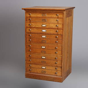
Sold2020Eight Drawer Oak Map, Art or Print File Cabinet, C 1910An antique map, art or print fining cabinet offers oak construction with eight drawers, brass pulls throughout, c1910. Measures- 45.5" H x 28" W x 22.75" D. ***IN-HOUSE SHIPPING & DELIVERY QUICK QUOTESee Sold Price
Sold2021Findlay, Alex C1835 Antique Map. Tasmania Australia"Van Diemens Land" Steel Engraved Map Published C1835 by Thomas Kelly, London for "A New and Universal English Dictionary" by the Rev. James Barclay. Maps Drawn & Engraved by Alexander Findlay. PaperSee Sold Price
Sold2024Matthaus Merian 1627 Antique Map Engraving "Virginia" from Theodore de Bry's "Grand Voyages" #1Antique 1627 map of Virginia by Matthaus Merian after John Smith's 1612 map, from Theodore de Bry's "Grand Voyages". Please see "The Philidelphia Print Shop" sheet shown in final photo. Good conditionSee Sold Price
Sold2023Collection of Antique Prints "Cities of the World"Antique prints and etchings depicting "Cities of the World" - including Harper's Weekly illustrations, landscapes, antique maps, depictions of notable landmarks and famous cities such as Paris, New YoSee Sold Price
Sold20192 Mid Century Artist Exhibition Posters. CALDER.2 Mid Century Artist Exhibition Posters. CALDER. JOHNS. Alexander Calder graphic print Hokin Gallery Inc. Chicago. Jasper Johns "Map" Museum of Modern Art NY. Both in chrome frames.-- Dimensions: ImagSee Sold Price
Sold2024De Jode, Rare, pub. 1593 - Map of the Holy Land (Descriptio Et Situs Terrae Sanctae Alio NomineThis map of the Holy Land is entitled Descriptio Et Situs Terrae Sanctae Alio Nomine Palestina Multis Preclaris Historys Et Miraculis Utriusque Testamenti A Christo Salvatore nobilitata. The map is beSee Sold Price
Sold2023Seutter - Map of North America including Great Lakes, Florida, Virginia, New England, Mexico, WestThis engraving is from a composite atlas presented by the Homann Heirs. Many of the maps in the collection were completed by J. B. Homann, Homann Erben, M. Seutter, and T. C. Lotter. The maps were oriSee Sold Price
Sold2016Map of Bermuda, by Hondius 1633Map of Bermuda, by Hondius 1633. Original hand colored copper engraving. Showing the "tribes" that were granted by the gentleman onboard the shipwreck that force the European settlement of the island.See Sold Price
Sold2024De Jode, Rare, pub. 1593 - Map of Kingdom of Napoli, Italy (Neapolitani Regni exacta ac diligensThis truly significant map is from one of the rarest atlases ever published, Gerard and Cornelis de Jode's Speculum orbis Terrae. The work was published in Antwerp in 1593 by Arnold Coninx for the widSee Sold Price
Sold2024Blaeu's Tooneel des Aerdrycx - Fifth Volume with 55 Engraved MapsThis remarkable fifth volume of 55 maps with original hand-coloring is is Jan & Willem Blaeu's Tooneel des Aerdrycx, oft Nieuwe Atlas ? Vyfde Deel or Theatrum Orbis Terrarum, Dutch edition. This was pSee Sold Price
Sold2023Barclay, James 1834 Antique Print. Naples, Italy. ShipsSteel Engraving Published 1834 by Thomas Kelly, London for "A New and Universal English Dictionary" by the Rev. James Barclay. Maps Drawn & Engraved by Alexander Findlay. Paper Size: 10.5 x 8 inch (27See Sold Price
Featured1 day LeftJasper52COLONIAL CARIBBEAN. West Indies. Danish Virgin Islands.Telegraph cables 1886 mapUS$40
Featured1 day LeftJasper52West Indies. Haiti/Dominican Republic borders differ. BARTHOLOMEW 1886 old mapUS$10
4 days LeftTrillium Antique Prints & Rare BooksOxley - Map of the New South Wales, Australia (New Holland)US$100
1 day LeftJasper52GUADELOUPE & MARIE-GALANTE. Soufrière. Dugommier. Antilles. VUILLEMIN 1879 mapUS$25
1 day LeftJasper52West Indies from the best authorities by Richard Brookes 1812 old antique mapUS$100
1 day LeftJasper52Grand Bahama & Great Abaco Islands. Bahamas. ADMIRALTY sea chart 1886 (1968) mapUS$140
1 day LeftJasper52Bahamas. San Salvador Crooked Rum Cay Mariguana ADMIRALTY chart 1892 (1919) mapUS$140
4 days LeftRbfineartsHelmut Newton (German/Australian, 1920-2004) Elizabeth Taylor Print, Los Angeles, 1985US$50(1 bid)
4 days LeftTrillium Antique Prints & Rare BooksKollner, Rare - Baltimore, Maryland (North West View)US$200
4 days LeftTrillium Antique Prints & Rare BooksThornton - The Queen Flower (Bird of Paradise Flower)US$150(1 bid)
4 days LeftTrillium Antique Prints & Rare BooksDresser & Keulemans's A Monograph of the Meropidae, or Family of the Bee-Eaters - Volume with 34US$2,000
4 days LeftTrillium Antique Prints & Rare BooksKollner, Rare - New York (The Narrows and Part of Staten Island)US$200
7 hrs LeftJasper52Lady Charlotte Harley, Ianthe in Childe Harold's Pilgrimage - Antique engraving.US$40
4 days LeftTrillium Antique Prints & Rare BooksPrevost - Chart of the South Pacific Ocean with part of New Holland (Australia), New Zealand, andUS$75