Sold2023Seutter - Map of North America including Great Lakes, Florida, Virginia, New England, Mexico, WestThis engraving is from a composite atlas presented by the Homann Heirs. Many of the maps in the collection were completed by J. B. Homann, Homann Erben, M. Seutter, and T. C. Lotter. The maps were oriSee Sold Price
Sold2022Antique Map Print - America - Map Of Virginia - Canals, Roads & Distances - USATitle: Antique Map Print - America - Map Of Virginia - Canals, Roads & Distances - USA Date/Period: 1846 Dimension: 44 cm x 34 cm Material: Paper Additional Information: A New Map Of Virginia With ItsSee Sold Price
Sold2016Antique Middle States Map - 1872Antique Middle States Map - 1872, featuring Maryland, Virginia, West Virginia, Pennsylvania, New York & New Jersey. Size : 9" x 10.75"See Sold Price
Sold2023Antique Map Print - Five West Indies - North America - South America - 1701Title: Antique Map Print - Five West Indies - North America - South America - 1701 Date/Period: 1701 Dimensions: 15 cm x 13 cm Material: Paper Additional Information: A detailed small map from ”See Sold Price
Sold2016Antique Map : New York, New Jersey - 1870Antique Map : New York, New Jersey, Pennsylvania, Ohio, Delaware, Maryland , Virginia & West Virginia - 1870 Size : 15.5" x 18.5"See Sold Price
Sold2017Beers: Antique Map of Mid Atlantic Midwest US, 1875Title: 1875 Warner Beers Map of Mid Atlantic and Midwest United States -- County Map of New York, New Jersey, Pennsylvinia, Ohio, Deleware, Maryland, Virginia, West Virginia Cartographer: Warner BeersSee Sold Price
Sold2020c 1852 OLD MAP of WESTERN UNITED STATES by MITCHELL IAc 1852 OLD MAP of WESTERN UNITED STATES by MITCHELL IA MI MO IL IN KY OH VA WI Description: Circa 1852 Antique Map ??No. 14 - MAP OF THE CHIEF PART OF THE WESTERN SSTATES INCLUDING WEST VIRGINIA. By SSee Sold Price
Sold20241639 Jan Jansson Antique Map of North America Virginia to New York to New EnglandThis beautifully hand coloured, important original antique map of the north east regions of the United States from Virginia, Chesapeake Bay, to New York & New England by Jan Jansson was published in tSee Sold Price
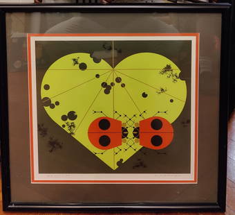
Sold2024Paul Spener Johst - Animated map of West VirginiaNeat animated West Virginia picture map which features sketches of people, agriculture, industry, and more. This is an original, not a reprint, antique picture map which was carefully removed from a rSee Sold Price
Sold20191848 Mitchell map of VirginiaFully hand-colored original, antique and scarce map that encompasses the future state of West Virginia. “A New Map of Virginia with its Canals, Roads & Distances from Place to Place Along the StageSee Sold Price
Sold2017Map of West Virginia coal field 1867Heading: Author: Swann, John S. Title: Title Map of the Coal Field of the Great Kanawha Valley, West Virginia, United States of America Place Published: New York Publisher:G.W. Colton & C.B. Colton &See Sold Price
Sold2023Old Steel Engraving Print - Moonlight over Harper's Ferry - West Virginia - USATitle/Artist: Old Steel Engraving Print - Moonlight over Harper's Ferry - West Virginia - USADate: 1874Material: PaperDimensions: 32 cm x 24 cmAdditional Information: Antique steel engraving originateSee Sold Price
Sold2024Charley Harper L/E Ladybug Lovers Serigraph PrintCharley Harper (Ohio, West Virginia, 1922 - 2007) serigraph titled "Ladybug Lovers" pencil signed and numbered 994/1500. Very good condition under glass. 13" x 11.5" sight.See Sold Price
Sold2021Museum of American Glass Monograph PrintsDESCRIPTION: (2 Pc) A Pair of monograph prints from the "In the glass study series of The West Virginia Museum of American Glass". This set includes: (1) A "Dorothy Thorpe, Designer" monograph print nSee Sold Price
Sold20212 Charley Harper Bird Serigraphs, incl. Seeing Red,Two (2) Charley Harper (Ohio/West Virginia, 1922-2007) bird serigraphs on paper prints, including "Seeing Red" and "Baffling Belly (Red Bellied Woodpecker)". Both published by the Frame House Gallery,See Sold Price
Sold20223 Charley Harper Bird Serigraphs, incl. The Last SunflowerThree (3) Charley Harper (Ohio/West Virginia, 1922-2007) bird serigraph on paper prints, including "The Last Sunflower", "Yellow-Bellied Sapsucker", and "Hexit". All published by Frame House Gallery,See Sold Price
Sold20223 Charley Harper Animal Serigraphs, incl. Bear in Birches & Cool CarnivoreThree (3) Charley Harper (Ohio/West Virginia, 1922-2007) animal serigraph on paper prints, including "Bear in the Birches", "Cool Carnivore", and framed "Watermelon Moon". All published by the Frame HSee Sold Price
Sold2021Laurie and Whittle Antique MapLaurie and Whittle Antique Map , "A New and General Map of the Middle Dominions Belonging to the United States of America, viz. Virginia, Maryland, the Delaware-Counties, Pennsylvania, New Jersey...",See Sold Price
Sold2019Civil War N. America with odd DakotaThis uncommon Civil War era engraved map shows a very unusual configuration for Dakota. West Virginia hasn’t separated from Virginia, which puts the map sometime before 1863. In this map the bordersSee Sold Price
Sold2018Bonne: Antique Map of Louisiana and Florida, 1780Carte de la Louisiane et de la Floride Bonne's detailed map of the Mississippi basin and southeastern North America, from Florida to Virginia. Features good topographical detail, many place names andSee Sold Price
Sold202311 Engraved Scenic Views and Maps inc. UVA, GA Female College, plus Postcard AlbumGroup of eleven (11) antique prints and lithographic maps. Includes University of Virginia, Charlottesville by W. Goodacre, published London, 1831 by I.T. Hinton, Simpkin & Marshall; Georgia Female CoSee Sold Price
Sold2024Matthaus Merian 1627 Antique Map Engraving "Virginia" from Theodore de Bry's "Grand Voyages" #1Antique 1627 map of Virginia by Matthaus Merian after John Smith's 1612 map, from Theodore de Bry's "Grand Voyages". Please see "The Philidelphia Print Shop" sheet shown in final photo. Good conditionSee Sold Price
Sold20231755 Robert De Vaugondy Map of North America Large1755 Robert De Vaugondy Map of America. Mid-Atlantic, New York, New Jersey, Pennsylvania Virginia, Maryland, New England, Carolina and Ohio. Partie De L'Amerique Septentrionale. Map in matte is aboutSee Sold Price
Sold2023Assorted Antique Prints of VirginiaAssorted antique prints, engravings, etchings, and other medias of VIRGINIA, including scenic landscapes, vintage maps, notable cities/towns and landmarks, assorted Harper's Weekly illustrations and oSee Sold Price
4 days LeftJasper52SOUTHERN MEXICO & CENTRAL AMERICA. Lighthouses. Key West Yucatan. LETTS 1889 mapUS$10
4 days LeftJasper52SOUTHERN MEXICO & CENTRAL AMERICA. Lighthouses. Key West Yucatan. LETTS 1884 mapUS$15
4 days LeftJasper52CARIBBEAN.C. America West Indies;Panama canal;Jamaica;Leeward Windward 1909 mapUS$10
4 days LeftJasper52CENTRAL AMERICA/WEST INDIES COMMERCIAL. Agricultural products. Havana 1920 mapUS$8
4 days LeftJasper52SOUTHERN MEXICO & CENTRAL AMERICA. Lighthouses. Key West Yucatan. LETTS 1883 mapUS$15
Featured4 days LeftJasper52South America by George Heriot SWANSTON 1860 old antique map plan chartUS$20
4 days LeftJasper52Spanish North America, southern part by John Thomson. Central America 1817 mapUS$85
4 days LeftJasper52SOUTH AMERICA SOUTH SHEET. Shows Bolivia claim on Gran Chaco. JOHNSTON 1912 mapUS$8
4 days LeftJasper52S AMERICA. Patagonia La Plata.Bolivia with Litoral.New Granada/Colombia 1886 mapUS$8
Featured4 days LeftJasper52SOUTH AMERICA SOUTH SHEET. Shows Bolivia claim on Gran Chaco. JOHNSTON 1913 mapUS$8
Featured4 days LeftJasper52South America by Joseph Wilson Lowry. Banda Oriental. Patagonia 1860 old mapUS$35
Featured4 days LeftJasper52South America. New Granada & Venezuela. Colombia Panama. SWANSTON 1860 old mapUS$50