Sold2017Ancient World Maps, Mela Posidonius & Ptolemy 1683 MapAncient World. Maps by Mela, Posidonius & Ptolemy. Mallet 1683 Old Antique. Title of the Map: 'globe De Mella; Globe De Posidonius; Globe De Ptolomee' date Printed: 1683 image Size: Approx Overall PagSee Sold Price
Sold20211830 "A New Atlas World" Educational School Map Book1830 "A New Atlas World"Antique Educational School Maps. This is a wonderful antique atlas for early education, geography classes. It has a layout of the world and the breakdown of each continent. BecSee Sold Price
Sold2022ANTIQUE WORLD MAPS AND AMERICAN HISTORY BOOKSA lot of eight antique and vintage historical books and maps. Arbuckles Illustrated Atlas of Fifty Principal Nations of the World, 1890. Lois Marie Hunter, The Shinnecock Indians, 1960. Replogle WorldSee Sold Price
Sold2020LOT WORLDS FAIR ITEMS INCL. MAPS, BOOKS, BROCHURESLOT ASST. WORLDS FAIR ITEMS INCL. MAPS, BOOKS, BROCHURES, C. 1939/40See Sold Price
Sold2021Stielers Hand-Atlas: German World Maps 1933Handy atlas of all parts of the world and of the universe, original bound books of world maps in German, dating to 1933. Appears complete with lots of mono and color maps. Binding tight but spine coveSee Sold Price
Sold2021Hardcover "Nelson's Map Book of the World Wide War"Hardcover "Nelson's Map Book of the World Wide War" 1914-1916 By Thomas Nelson & Sons Limited Condition: Poor. The front and back cover are no longer attached, bottom edges by binder are frayed. PleasSee Sold Price
Sold2017VARIOUS ATLAS AND MAP BOOKSVARIOUS ATLAS AND MAP BOOKS- RAND McNALLY FAMILY WORLD ATLAS- SIXTH PRINTING 1987- HARD COVER- THE MAP BOOK EDITED BY PETER BARBER- FIRST PUBLISHED IN THE U.S. IN 2005- HARD COVER- THE MAP CATALOG- 3RSee Sold Price
Sold201519th C. Belgian Oil Genre Scene, "The Governess"Belgian School, 19th century. "The Governess", oil on canvas, unsigned. Genre painting depicting three women sitting in a decorated library among books and maps of the world, the governess sitting inSee Sold Price
Sold20211939 New York World's Fair Guide Book, foldout map and1939 New York World's Fair Guide Book, foldout map and souvenirSee Sold Price
Sold2023ATLASES AND POCKET MAPS. 3 PIECES TOGETHERATLASES AND POCKET MAPS. A lot of 3 pieces sold together. Generally good condition, various imperfections. Including: Wyld, James. WORLD MAP. London: James Wyld, n.d. 12mo. Folding map, mounted to cloSee Sold Price
Sold20191800 Geography ATLAS MAPS John Walker India Asia World1800 Geography ATLAS MAPS John Walker India Asia World Map John Walker’s ‘Elements of Geography’ is an incredibly late 18th-century English atlas known for its impressive folding maps. This atlaSee Sold Price
Sold20211790 Geography Dictionary World MAPS Europe History1790 Geography Dictionary World MAPS Europe History French Laurence Echard Laurence Echards Geographic Dictionary is a rare, late 18th-century history of world. This book is organized much like a modeSee Sold Price
Sold20231810 Modern Geography America MAP + World Map Massachusetts Elijah Parish1810 Modern Geography America MAP + World Map Massachusetts Elijah Parish Elijah Parishs “New System of Modern Geography” is an early 19th-century American geography textbook. Published inSee Sold Price
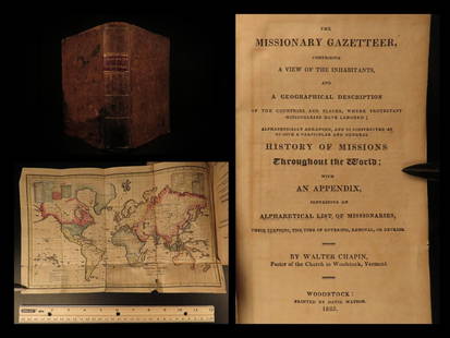
Sold20211825 1ed Missionary Gazetteer Chapin Slavery Indians1825 1ed Missionary Gazetteer Chapin Slavery Indians Illustrated Color World MAP ‘Missionary Gazetteer’ is a general history of missions throughout the world arranged alphabetically with an appendSee Sold Price
Sold20201761 George Anson Voyage Round the World MAPS Spain1761 George Anson Voyage Round the World MAPS Spain South America Brazil Peru George Anson was an 18th-century British Navy admiral who is noted for his important world voyage in which he circumnavigaSee Sold Price
Sold20201762 George Anson VOYAGE Round the World MAPS Spain1762 George Anson VOYAGE Round the World MAPS Spain South America Brazil Peru George Anson was an 18th-century British Navy admiral who is noted for his important world voyage in which he circumnavigaSee Sold Price
Sold20191764 George Anson Voyage Round the World MAPS South1764 George Anson Voyage Round the World MAPS South America Brazil Peru Chile George Anson was an 18th-century British Navy admiral who is noted for his important world voyage in which he circumnavigaSee Sold Price
Sold20191843 Folding Color German World Maps Europe Americas1843 Folding Color German World Maps Europe Americas Geography Austria RARE Three 19th-century world maps published in Vienna in 1843! Published for use in Austrian high schools, this atlas includes fSee Sold Price
Sold2020FRAMED WORLD MAPCondition: with crease mark from book, spotting, and foxing throughout 11 x 16 1/2 inches sightSee Sold Price
Sold201519TH & 20TH CENTURY MAPS AND BOOKS1.) 1887: With several fold out maps of the countries and a World Map: Ed. Robinson, Nugent, History of the World with all its Great Sensations Together with its Mighty and Decisive Battles and the RiSee Sold Price
Sold20167 Vols: Plate/map books, 1700s.[18th Century Plate/Map Books] 6 Titles (7 Vols). ++ A NEW GEOGRAPHICAL DICTONARY, CONTAINING A FULL AND ACCURATE ACCOUNT OF THE SEVERAL PARTS OF THE KNOWN WORLD… 2 Vols. Lon: J. Coote, 1759-60. FolSee Sold Price
Sold2022(18) NATIONAL GEOGRAPHIC MAPS, c.1930s-1940s(lot of 18) National Geographic Maps, world maps dated late 1930s to 1940s, with many notes, mileage, and more, housed in book-form album, approx 10.75"h, 7.5"w, 2.25"d, 3.25lbs Start Price: $40.00See Sold Price
Sold2022MAPS IN BOOK, Atlases, CareyCarey's Famous 1814 General Atlas. Atlases. Mathew Carey, Carey's General Atlas, Improved and Enlarged: Being a Collection of Maps of the World and Quarters, Their Principal Empires, Kingdoms, &c., 18See Sold Price
Sold20201883 1st Esoteric Occult Rivers of Life Forlong1883 1st Esoteric Occult Rivers of Life Forlong World Religions MAP Illustrated Major-General Forlong was a military engineer and scholar of world religions. Forlong’s ‘Rivers of Life’ is a two-See Sold Price
May 12Schilb Antiquarian Rare Books1977 JRR Tolkien 1st ed 1st Printing Silmarillion Lord of the Rings + MAP + DJUS$200(5 bids)
May 04Trillium Antique Prints & Rare BooksMitchell's A New Universal Atlas.. - Volume with 73 MapsUS$1,000(1 bid)
Featured3 days LeftJasper521771 ASTRONOMY by Joseph M. de La Lande 2 VOLUMES ILLUSTRATED antique in FRENCHUS$480
5 mins LeftTrillium Antique Prints & Rare BooksPtolemy & Magini, pub. 1620 - Map of the World with Six WindheadsUS$160(4 bids)
5 mins LeftTrillium Antique Prints & Rare BooksPtolemy & Magini, pub. 1620 - Double Hemisphere Map of the WorldUS$400(5 bids)
5 mins LeftTrillium Antique Prints & Rare BooksCarey, pub. 1814 - Map of the State of TennesseeUS$85(2 bids)
5 mins LeftTrillium Antique Prints & Rare BooksCarey, pub. 1814 - Map of the Mississippi TerritoryUS$85(2 bids)
May 04Trillium Antique Prints & Rare BooksCarey, pub. 1814 - Map of the East Indies with India, China, & New Holland (Australia)US$50(1 bid)
5 mins LeftTrillium Antique Prints & Rare BooksCarey, pub. 1814 - Map of Scotland with the Principal RoadsUS$50
May 04Trillium Antique Prints & Rare BooksPtolemy & Magini, pub. 1620 - Map of the Ancient World with Africa, Europe, AsiaUS$50
May 04Trillium Antique Prints & Rare BooksQuin - Map of AD 1783 Independence of the United StatesUS$50


![7 Vols: Plate/map books, 1700s.: [18th Century Plate/Map Books] 6 Titles (7 Vols). ++ A NEW GEOGRAPHICAL DICTONARY, CONTAINING A FULL AND ACCURATE ACCOUNT OF THE SEVERAL PARTS OF THE KNOWN WORLD… 2 Vols. Lon: J. Coote, 1759-60. Fol](https://p1.liveauctioneers.com/179/93063/47518669_1_x.jpg?height=310&quality=70&version=1473187115)


