Sold2017Kobayashi: Map of Japan, 1906Map: Map of Japan. Publication Date: 1906-11-01 Size: Folio – 22.75 H x 33.75 W Inches Authors: THE WELCOME SOCIETY, KOBAYASHI, H. Publisher: THE WELCOME SOCIETY Sixth edition, revised. Cover title:See Sold Price
Sold2019Japan 1906 LG Rare Folding Map. Welcome Society"Map of Japan by the Welcome Society" Large Folding Lithograph Published 1905, Tokyo. Engraved by H. Kobayashi, Lithographed by The Tokio Printing Co. Fith Edition. Paper Size: 33 x 23 inch (84 x 59cmSee Sold Price
Sold2018Cram: Antique Map of Japan, 1906Title/Content of Map: Japan Cartographer: CRAM, GEORGE F. Size: 13X16.5 "Published by Geo. F. Cram, Chicago, Ill." From Grant's Bankers' and Brokers' railway system atlas, cover dated 1906. On polar pSee Sold Price
Sold2022Japan.- Taiwan.- Mitchell (Charles Archibald) Camphor in Japan and in Formosa, first edition,Japan.- Taiwan.- Mitchell (Charles Archibald) Camphor in Japan and in Formosa, first edition, printed on crepe paper, some light creasing, folding map of Taiwan at rear, floral endpapers, original roaSee Sold Price
Sold2022Corea and Japan by John Thomson. East Asia. Korea 1817 old antique map chartTITLE/CONTENT OF MAP: 'Corea and Japan' DATE PRINTED: Published in 1817. Engraved on 16th August 1815; this date is marked on the map IMAGE SIZE: Approx 52.5 x 67.0cm, 20.75 x 26.5 inches (Large); PleSee Sold Price
Sold2022Corea and Japan by John Thomson. East Asia. Korea 1830 old antique map chartTITLE/CONTENT OF MAP: 'Corea and Japan' DATE PRINTED: 1830 IMAGE SIZE: Approx 52.0 x 66.5cm, 20.5 x 26.25 inches (Large); Please note that this is a folding map. TYPE: Antique early 19th century atlasSee Sold Price
Sold2023Corea and Japan by John Thomson. East Asia. Korea 1817 old antique map chartTitle: "Corea and Japan" by John Thomson. East Asia. Korea 1817 old antique map chart Description: Corea and Japan' by Drawn & engraved by John & George Menzies for John Thomson's "New General Atlas"See Sold Price
Sold2022Antique Japanese MapAntique Japanese Map, Marked Ishi-Kawa-Ryugi, Genroku Yonen-Ban-Nippon-zu, Tokyo, Sagamiya, 1691, Maps Of Japan. Folded Approximately 10.375L x 7.0625W in. Unfolded Approximately 66L x 40.25W in.See Sold Price
Sold2022Large Antique Japanese Map, SignedLarge Antique Japanese Map, Signed with Japanese characters in upper portion of the image as well as lower left. Multiple punctures in map. Provenance: important North Carolina estate. Overall framedSee Sold Price
Sold2023Japanese Map of Ancient China, Apparently 12th - 16th CenturyAn exceptional and rare early Japanese map, hand painted, depicting China from the Zhou or Qin Dynasty. The map depicts the Chinese Nine Zhou, or provinces, utilizing nomenclature used in Japan circaSee Sold Price
Sold2022[WORLD WAR II]. Collection of photographs, Japanese maps, and a diary collected by USN Lt. Cmdr. J.[WORLD WAR II]. Collection of photographs, Japanese maps, and a diary collected by USN Lt. Cmdr. J. John Fox while stationed in the Pacific, including: 53 reconnaissance photos from the Battle of OkinSee Sold Price
Sold2016Mixed media, Paul HoriuchiPaul Horiuchi (American/Japanese, 1906-1999), "Maple in the Snow," 1967, mixed media on board, signed lower right, titled and dated verso, sight: 17.5"h x 23.75"w, overall (with frame): 22.5"h x 28.5"See Sold Price
Sold2022MAP, Japan & Korea, MercatorHondius' Richly Ornamented Map of Japan. Japan & Korea. Mercator/Hondius, Iaponia, from Gerardi Mercatoris - Atlas sive Cosmographicae, 1634 (published). Hand Color. Superb map of Japan based on the OSee Sold Price
Sold2019Japanese Woodblock MapTitle/Content of Map: Japanese Woodblock Map Date Printed: Unknown. Prob. 19th c. Cartographer: Unknown Material/Medium: Woodblock Engraving. Size: 17.25 x 12.75 inches Of unknown place or origin, butSee Sold Price
Sold2022Pair of Signed Japanese Porcelain Map Vases.Marked on underside of each vase, "Made in Tainpou Years" (Edo period, 1830-1843). From an Oakland Gardens, NY estate. Dimensions: vases measure approx. 14.5" high.See Sold Price
Sold2022MAP, Japan & Korea, JanssonJapan & Korea. Jan Jansson, Nova et Accurata Iaponiae, Terrae Esonis, ac Insularum Adjacentium. Ex Novissima Detectione Descriptio, from Atlas Contractus, 1666 (circa). Hand Color. This superb folio mSee Sold Price
Sold2021Lot Japanese woodblocks & 1906 calendar, "MonthlyLot Japanese woodblocks & 1906 calendar, "Monthly Changes of Japanese Street-ScenesSee Sold Price
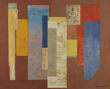
Sold2023Paul Horiuchi "Poetry of the Past" Collage 1976Paul Horiuchi (Japanese/American, 1906-1999). Collage and oil on canvas titled "Poetry of the Past," in his signature style typical of his time spent in the American Pacific Northwest, 1976.See Sold Price
Sold2021Paul Horiuchi - RitualLot 21 Paul Horiuchi Japanese/American (1906-1999) Ritual (1975) oil and collage on canvas signed lower right 49 1/2 x 58 1/2 inches Provenance: Collection of Josie Natori, NYSee Sold Price
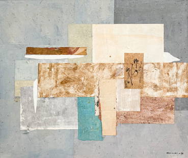
Sold2021Amazing Paul Horiuchi (1906-1999) Collage BoardPaul Horiuchi collage board, 37 x 28 inches. Provenance: private owner from Atlanta. Biography: Horiuchi was born on the shores of Lake Kawaguchi in Japan in 1906 and as a young man studied calligraphSee Sold Price
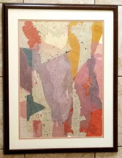
Sold2022Amazing Paul Horiuchi Watercolor PaperNice Paul Horiuchi watercolor paper. 28.5 x 23 inches. Provenance: private owner. Biography: 1906 - 1999. Horiuchi was born on the shores of Lake Kawaguchi in Japan in 1906 and as a young man studiedSee Sold Price
Sold2020Japanese 6-Panel Screen Map, c. 19th CenturyA Japanese hand painted screen possibly depicting a map of bay regions in Japan. The piece is presented predominantly in shades of blue and brown with vibrant gilt detailing. The screen features six pSee Sold Price
Sold2017Ortelius: First Map of Japan in European Atlas, 1595Title: Iaponiae Insulae Descriptio. Ludoico Teisera Auctore. [first map of Japan published in European atlas] Map maker: Abraham Ortelius, Theatrum Orbis Terrarum Place and Year: Antwerp, 1595 DimensiSee Sold Price
Sold20181740 Seutter Map of Japan -- Imperium Japonicum perTitle/Content of Map: 1740 Seutter Map of Japan -- Imperium Japonicum per Sexaginta et Sex Regiones Digestum atque ex Ipsorum Japonensium Mappis Descriptum … Date: 1740 c., Augsburg Cartographer: MSee Sold Price
20 hrs LeftJeschke Jadi Auctions Berlin GmbHMoser, Carl In Erwartung. 1906/1914. Farbholzschnitt auf feinem Japan. 33,4 x 21,6 cm (35,3 x 25,5€800
Jun 30GOLDEN SUN AUCTIONS, Inc. (formerly Appraisal & Estate Sale Specialists, Inc.)1906 Robert Browning Last Ride Together-Signed-NumberedUS$50(3 bids)
1 day LeftTrillium Antique Prints & Rare BooksValentijn - Early Views and Map of Tasmania, Australia; Anthony van Diemen's LandUS$100
1 day LeftTrillium Antique Prints & Rare BooksSanson - Map of the Antilles Islands or West Indies with part of FloridaUS$75
6 days LeftA.H. Wilkens Auctions & AppraisalsBARRIE & RACKHAM. PETER PAN IN KENSINGTON GARDENSCA$2,000
1 day LeftTrillium Antique Prints & Rare BooksValentijn - First Published View of Swan River, Perth, Western Australia with Black Swans (lowestUS$100
6 days LeftA.H. Wilkens Auctions & AppraisalsLEVINE & MICHENER. FACING EAST, LTD EDITION (1970)CA$250
Jun 29Trillium Antique Prints & Rare BooksKollner, Rare - New York (The Narrows and Part of Staten Island)US$200
Jun 29Trillium Antique Prints & Rare BooksKollner, Rare - Baltimore, Maryland (North West View)US$200
Jul 01Japan-Miyako-Collection-Art Auction-Co-LtdIn the Qing Dynasty, bamboo carved bangs and golden toad ornamentsUS$200


![[WORLD WAR II]. Collection of photographs, Japanese maps, and a diary collected by USN Lt. Cmdr. J.: [WORLD WAR II]. Collection of photographs, Japanese maps, and a diary collected by USN Lt. Cmdr. J. John Fox while stationed in the Pacific, including: 53 reconnaissance photos from the Battle of Okin](https://p1.liveauctioneers.com/197/250551/130130063_1_x.jpg?height=310&quality=70&version=1654185975)


![Ortelius: First Map of Japan in European Atlas, 1595: Title: Iaponiae Insulae Descriptio. Ludoico Teisera Auctore. [first map of Japan published in European atlas] Map maker: Abraham Ortelius, Theatrum Orbis Terrarum Place and Year: Antwerp, 1595 Dimensi](https://p1.liveauctioneers.com/5584/108292/55552479_1_x.jpg?height=310&quality=70&version=1503667951)


![[EAST] LOT OF 3 VOLUMES SOLD TOGETHER (1 of 5)](https://p1.liveauctioneers.com/8124/333020/179782281_1_x.jpg?height=282&quality=70&version=1718304262)


