Sold2021Ɵ CARY, JOHN. NEW AND CORRECT ENGLISH ATLAS. 1825Ɵ CARY, John. New and Correct English Atlas. single volume, engraved title and 47 maps, coloured in outline, modern half calf over original boards, 4to, 1825. (Qty. 1).See Sold Price
Sold2018Britain.- Cary (John) Cary's New and Correct EnglishBritain.- Cary (John) Cary's New and Correct English Atlas, engraved title, dedication and 47 maps hand-coloured in outline, occasional foxing or offsetting, bookplate, contemporary morocco-backed boaSee Sold Price
Sold2023Cary, John 1823 Hand Col Map. RutlandshireHand Colored Copper Engraved Map Published 1823, London for "Cary's New and Correct English Atlas..." by John Cary. Paper Size: 12.5 x 9 inch (32 x 23cm) Good ConditionSee Sold Price
Sold2023Cary, John 1823 Hand Col Map. NorthamptonshireHand Colored Copper Engraved Map Published 1823, London for "Cary's New and Correct English Atlas..." by John Cary. Paper Size: 12.5 x 9 inch (32 x 23cm) Good ConditionSee Sold Price
Sold2020Cary, John 1787-90 Pair of Maps of Staffrodshire, UKHand Colored Copper Engraved Maps Published 1787, Lond for "Cary's New & Correct English Atlas" Together with a smaller Map of Staffordshire Published 1790, London for "Cary's Traveller's Companion" bSee Sold Price
Sold20201798 1ed Cary ROADS New Itinerary England Wales1798 1ed Cary ROADS New Itinerary England Wales Topography Atlas Travel Guide John Cary was a famous English cartographer from the 18th-century. Cary gained his reputation as a map maker from his workSee Sold Price
Sold2016John Cary: Portugal 1819Map: Portugal Maker: John Cary Publishing: John Cary, London Date: 1819 Size: 11 x 8.9 inches (280 x 225mm) Medium: Hand colored engraving From Cary's New Universal Atlas John Cary (1754-1835) was anSee Sold Price
Sold20201808 CARY JOHN (1754 - 1835) INCISIONE in bianco e nero1808 CARY JOHN (1754 - 1835) INCISIONE in bianco e nero con i confini colorati "Sicily" (cm 23 x 28,5) tratta da New universal atlas. Misure: cm 33,2 x 26See Sold Price
Sold2017Cary: Map of the United States, 1811An original 1811 framed hand colored engraved map titled "A New Map of the United States of America from the Latest Authorities" created by John Cary for the 2nd edition of his New Universal Atlas oriSee Sold Price
Sold2022John Senex Map of Louisiana & Mississippi River 1721John Senex (English, 1678-1740). "Map of Louisiana and the River Mississippi," from "A New General Atlas," London, 1721. Dedicated to William Law of Lanreston. This map is an EngliSee Sold Price
Sold2016Antique Map, A New Map of the County of CornwallC. Smith (British, 19th century), "A New Map of the County of Cornwall Divided into Hundreds," 1804, hand-colored copper engraved map, published in Smith's New English Atlas, with the Jones & Smith scSee Sold Price
Sold2015Ellis (John) - Ellis's English Atlas, or, A Compleatcomplete with 50 maps, numbered 1, 3, then 5 to 52, corresponding in quantity to the published index numbered 1, 2, then 5 to 52, engraved maps, the first two folding out to 485 x 420mm. and 530 x 430See Sold Price
Sold2016Atlantic Islands. The New General Atlas. John Thomson.Maker: Thomson, John. Origin: Edinburgh, Thomson, 1817. Medium: Original engraving hand-colored at publication. Sheet size: 21 x 26 in. No Reserve: This lot starts at $1 and has no reserve as a courteSee Sold Price
Sold2016Holland. The New General Atlas. John Thomson.Maker: Thomson, John. Origin: Edinburgh, Thomson, 1817. Medium: Original engraving hand-colored at publication. Sheet size: 26 x 21 in. No Reserve: This lot starts at $1 and has no reserve as a courteSee Sold Price
Sold2016Germany. The New General Atlas. John Thomson.From The New General Atlas Maker: Thomson, John. Origin: Edinburgh, Thomson, 1817. Medium: Original engraving hand-colored at publication. Sheet size: 21 x 26 in. No Reserve: This lot starts at $1 andSee Sold Price
Sold2016European Russia. The New General Atlas. John Thomson.Maker: Thomson, John. Origin: Edinburgh, Thomson, 1817. Medium: Original engraving hand-colored at publication. Sheet size: 26 x 21 in. No Reserve: This lot starts at $1 and has no reserve as a courteSee Sold Price
Sold2016Attica. The New General Atlas. John Thomson.Maker: Thomson, John. Origin: Edinburgh, Thomson, 1817. Medium: Original engraving hand-colored at publication. Sheet size: 21 x 13 1/4 in. No Reserve: This lot starts at $1 and has no reserve as a coSee Sold Price
Sold2016The Netherlands. The New General Atlas. John ThomsonFrom The New General Atlas Maker: Thomson, John. Origin: Edinburgh, Thomson, 1817. Medium: Original engraving hand-colored at publication. Sheet size: 21 x 26 in. No Reserve: This lot starts at $1 andSee Sold Price
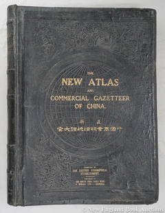
Sold2023Dingle, Edwin John51. Dingle, Edwin John. The New Atlas and Commercial Gazetteer of China. 28 color-printed maps and 18 color-printed statistical tables. Large folio, publisher's black cloth decorated in gilt and blindSee Sold Price
Sold2017A New Map of the West India Isles, Carey, 1687A New Map of the West India Isles. The beautifully colored, highly detailed West Indies map from Cary's New Universal Atlas encompasses Florida and southeastern North America, part of Mexico, all of CSee Sold Price
Sold20181814 ATLAS Maps of England & Wales Scotland Color Nav1814 ATLAS Maps of England & Wales Scotland Color Navigation Travel John Cary An incredible atlas consisting of 42 color maps of Great Britain by John Cary. The atlas covers cities in England, Wales,See Sold Price
Sold2019Two Maps from John Thomson's New General Atlas, "NorthTwo Maps from John Thomson's New General Atlas, "North America," 1814, and "Poland," America- H. - 21 1/2 in., W. - 28 1/2 in., Poland- H.- 21 in., W.- 27 1/2 in.See Sold Price
Sold2024Spanish North America. THOMSON. Texas, Mexico & Southwestern USA 1817 mapTitle: "Spanish North America". THOMSON. Texas, Mexico & Southwestern USA 1817 map Description: Spanish North America [northern part] by Drawn & engraved for John Thomson's "New General Atlas" (PublisSee Sold Price
Sold2023North America by John Thomson. Forts, Missions & Indian settlements 1817 mapTitle: "North America" by John Thomson. Forts, Missions & Indian settlements 1817 map Description: North America' by Drawn & engraved by Nathaniel Robert Hewitt for John Thomson's "New General Atlas"See Sold Price
7 days LeftForum AuctionsLondon.- Cary (John) Cary’s New and Accurate Plan of London and Westminster, the Borough of£1,000
7 days LeftForum AuctionsLondon.- Cary (John) Cary's New Pocket Plan of London, Westminster and Southwark, 1790£100
Jun 07Freeman's | Hindman[HARDY, Thomas, Sr., and HARDY, Thomas, Jr., their copy]. ASH, John. The New and Complete DictionaryUS$200
May 27Luther AuctionsEarly English sterling silver tankard - hallmarks for New Castle (1757-58) & John Langland - 26 troyUS$750
Jun 06Freeman's | HindmanSTEINBECK, John. The Moon is Down. FIRST EDITION IN CLOTH, second issue, SIGNED. With another copyUS$200
6 days LeftDoyle New YorkGeorge III Mahogany Settee Circa 1780, in the manner of John LinnellUS$1,500
5 days LeftDoyle New YorkGroup of Four George III Sterling Silver Marrow Spoons, Including a PairUS$150(1 bid)


![(ATLAS) CARY, JOHN. [New and Correct English Atlas.] First Image](https://p1.liveauctioneers.com/197/46511/21177409_1_x.jpg?height=300&quality=1&version=1382028574&width=300)
![(ATLAS) CARY, JOHN. [New and Correct English Atlas.] First Image](https://p1.liveauctioneers.com/197/46511/21177409_1_x.jpg?height=300&quality=95&version=1382028574&width=300)


![Spanish North America. THOMSON. Texas, Mexico & Southwestern USA 1817 map: Title: "Spanish North America". THOMSON. Texas, Mexico & Southwestern USA 1817 map Description: Spanish North America [northern part] by Drawn & engraved for John Thomson's "New General Atlas" (Publis](https://p1.liveauctioneers.com/5584/314775/168780323_1_x.jpg?height=310&quality=70&version=1704837726)


![[HARDY, Thomas, Sr., and HARDY, Thomas, Jr., their copy]. ASH, John. The New and Complete Dictionary (1 of 2)](https://p1.liveauctioneers.com/197/329395/177650382_1_x.jpg?height=282&quality=70&version=1715364962)

![[MAP]. SPEED, John. A New Mappe of the Romane Empire. 1676. (1 of 2)](https://p1.liveauctioneers.com/197/329395/177650541_1_x.jpg?height=282&quality=70&version=1715364962)


