Sold20191961 General Drafting Co./Esso Civil War Pictorial MapTitle: 1961 General Drafting Co./Esso Civil War Pictorial Map of Battles -- A Pictorial Map Showing Historical Shrines and Battlefields of the Civil War 1861-1865 Date: 1961, Convert Station, NJ CartoSee Sold Price
Sold2019The Battle of ChancellorsvilleThe Battle of Chancellorsville Maps & engraved portraits of Joseph Hooker and Stonewall Jackson. Author: Samuel P. Bates Illustrations Gravures MSee Sold Price
Sold20171876 U.S. War Department Map of Belmont, MO Civil WarTitle/Content of Map: 1876 U.S. War Department Map of Belmont, MO Civil War Battle -- Map of the Battlefield near Belmont, Missouri ... Commanded by Brig. Gen. U.S. Grant, Nov. 7th 1861 Date Printed:See Sold Price
Sold2018German Historic War Maps, Towns, and Sieges17th and 18th Century German Cartography School, Various Maps showing Battles, Settlements, Wars at German, Swedish, and Dutch Cities, copperplate engravings, approximately 12 x 14.5 inches, approximaSee Sold Price
Sold2022Rare 1818 Map Showing the Battle of Bunker Hill Sketched by Witness Henry de BerniereRare 1818 Map Showing the Battle of Bunker Hill Sketched by Witness Henry de Berniere Engraved map, Ca. 1818, Charlestown, MA. Entitled "Sketch of the Action on the Heights of Charlestown 17 June 1775See Sold Price
Sold2020Civil War Kentucky Battle Field Antique MapMap of the Battle-field of Perryville, Ky., October 8th 1862. J.B. Work, Chicago, c. 1900. Antique print. 11 1/2" x 9".See Sold Price
Sold2022TWO MAPS OF CIVIL WAR INTEREST Late 19th Century Colored lithographs on paper, 17" x 28" sight.TWO MAPS OF CIVIL WAR INTERESTLate 19th Century"Plate XXXII Plan of the Battle on Stone River before Murfreesborough" and "Plate XLVI Map of the Battle-Field of Chickamauga", bothSee Sold Price
Sold2018Map of Chickamuga Civil War Battle Field ??Map of Chickamuga Battle Field l Dated: 19th Century Demensions: 5 x 7 1/2" Condition Report Water stained corners. Small chip top rigSee Sold Price
Sold2022Rare Rev. War map of Hudson River campaign, pre-Vermont, 1832Rare Revolutionary War battle map of the important Hudson River corridor showing northern New England and Quebec. This map is from the rare atlas from John Marshall’s “Life of Washington” publisSee Sold Price
Sold2022Scarce Amer. Rev. War map showing Manhattan, Marshall/Yeager 1832Scarce Revolutionary War battle plan of the New York Campaign of 1776, from Marshall's Life of Washington. Shows the American positions on Manhattan Island. Covers the strategically important ManhattaSee Sold Price
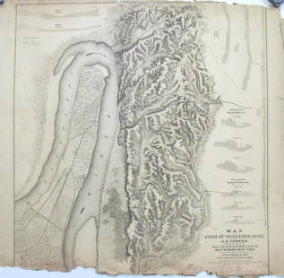
Sold2017Map of the Siege of Vicksburg, MississippiMap: Map of the Siege of Vicksburg, Mississippi Description: This large battle map identifies Union and Confederate entrenchments. It is very detailed, showing the roads, streets, houses, railroads, vSee Sold Price
Sold2023Civil War era 2-pg. map of Georgia & Alabama - 1863Map showing an area visited repeatedly by the Civil War (550 battles and skirmishes were fought in Georgia alone). Created at the height of the conflict, this actual cartographic document is what citiSee Sold Price
Sold2023Map, Battle of Cerro Gordo, 1847, Mex-American WarHand colored map by Captain John McClellan showing Mexican and U.S. troop positions for this decisive battle of the Mexican American War, April 17 & 18, 1847. Map includes artillery, topography, casuaSee Sold Price
Sold20221700's Dutch Map of Battle of YorktownA 1700s Dutch map outlining the Revolutionary War Battle of Yorktown Virginia showing encampments and rivers. Map measures 9" tall X 9" across.See Sold Price
Sold2024CHINA & JAPAN showing Opium Wars battlefields & dates. JOHNSTON 1913 old mapCAPTION PRINTED BELOW PICTURE: 'China and Japan // Islands of Japan' DATE PRINTED: 1913 IMAGE SIZE: Approx 34.5 x 43.5cm, 13.5 x 17.25 inches (Large); Please note that this is a folding map. TYPE: AntSee Sold Price
Sold20201892 Cowles Civil War Map of Battles in SoutheasternTitle: 1892 Cowles Civil War Map of Battles in Southeastern Virginia -- Military Department of Southeastern Virginia and Fort Monroe Showing the Approaches to Richmond and Petersburg, 1861 [Plate XVIISee Sold Price
Sold20231893 Civil War Map of the Battles of Bull Run and Manassas -- Plan of the Battle Field at Bull RunTitle: 1893 Civil War Map of the Battles of Bull Run and Manassas -- Plan of the Battle Field at Bull Run [with] Map of the Battle-Fields of Manassas… [Plate III] Cartographer: US War DepartmentSee Sold Price
Sold2021WILL HADDON (American. 20th Century)Bonhomme vs. Serapis. Signed l/l, reverse with a map of The British Isles, showing the battle site and date, Sept. 23, 1779, with title plaque. Oil on Masonite. 18.5 by 24 in., in a painted frame 26 bSee Sold Price
Sold2022Huge 1876 Historical Map of the U.S. by BlanchardHistoric Maps 1876 "Historical Map of the United States Showing Early Spanish, French & English Discoveries and Explorations, also Forts, Towns & Battlefields of Historic Interest" by Rufus BlanchardSee Sold Price
Sold2018Early Rhode Island Map:A French military map prepared for the Marquis de Lafayette showing American troop positions on August 30, 1778, after the Battle of Rhode Island. M'r Michel Capitaine du Chesnoy, A.d.C. du GénéralSee Sold Price
Sold2016Nashville Battlefields and TN MapTwo Tennessee related maps. 1st item: A NEW MAP OF TENNESSEE WITH ITS ROADS AND DISTANCES FROM PLACE TO PLACE ALONG THE STAGE AND STEAM BOAT ROUTES by H.P. Tanner, dated 1841, showing counties, canalsSee Sold Price
Sold2023Wood Shoes Found on the Battle Field During WW1 by Arthur Eddington along the Meuse River in BelgiumWood Shoes Found on the Battle Field During WW1 by Arthur Eddington along the Meuse River in Belgium near the Arogone Forrest in France. Map drawn on the bottom of the shoes with location of find.See Sold Price
Sold2016Civil War Map of Winchester, VATitle: Battle-Field of Winchester, VA September 19, 1864 and Battle-Fields of Fisher's Hill and Cedar Creek 22 Sept 1864, 19 Oct 1864 Maker: Washington Government Printing Office Date: 1892 Civil WarSee Sold Price
Sold2022Rare First American Revolutionary War Battle MapAmerican Revolution First American Printing Of A Revolutionary War Battle Map "A View of the Present Seat of War, at and near New-York." 1777-Dated (Printed 1776) Revolutionary War Period, Printed MapSee Sold Price
May 29Cedarburg Auction & Appraisals LLCSet of Four Maps Showing All of Spain and PortugalUS$25(1 bid)
7 days LeftJasper521892 Cowles Civil War Map of Battles in Gettysburg, Virginia, W Virginia and Maryland -- Sketch ofUS$55
May 31Freeman's | Hindman[CIVIL WAR]. Archive of items related to Elisha Hunt RHODES (1842-1917), 2nd Rhode Island VolunteerUS$750
Jun 02Schilb Antiquarian Rare Books1899 STONEWALL JACKSON Civil War Confederate Military + Wolseley PROVENANCEUS$2(2 bids)
7 days LeftJasper52Quarry Map Showing the Situation and Size of the More Important Slate Quarries in The "UnfadingUS$20
1 day LeftPotter & Potter AuctionsLISTER, James Wren (1897 – 1952). Avalon Town / Santa Catal...US$100(1 bid)
1 day LeftPotter & Potter AuctionsMcCARTY, Lea (1905 – 1960). Sonoma County / Its Highlights ...US$100(1 bid)
1 day LeftPotter & Potter AuctionsPan American Airways World System Map. 1956. Art by John Br...US$200
Jun 08Connoisseur AuctionsEarly 1900's Railway Service Map, Illinois, Ohio, Indiana, Kentucky, TennesseeUS$20
7 days LeftJasper521866 McNally Map of Huge Idaho, Dakota, Colorado, Nebraska, etc -- Nebraska, Kansas, Dakota,US$70
20 hrs LeftOriental Art AuctionsAL-IDRISI AND ROGER II, A MAP OF ASIA IN NUZHAT AL-MUSHTAQ, 17TH CENTURY€4,000
7 days LeftJasper52Sketch Showing the Progress of the Survey On The Atlantic, Gulf of Mexico and Pacific Coasts Of TheUS$25


![1893 Civil War Map of the Battles of Bull Run and Manassas -- Plan of the Battle Field at Bull Run: Title: 1893 Civil War Map of the Battles of Bull Run and Manassas -- Plan of the Battle Field at Bull Run [with] Map of the Battle-Fields of Manassas… [Plate III] Cartographer: US War Department](https://p1.liveauctioneers.com/5584/307299/164242651_1_x.jpg?height=310&quality=70&version=1698786194)


![[CIVIL WAR]. Archive of items related to Elisha Hunt RHODES (1842-1917), 2nd Rhode Island Volunteer (1 of 6)](https://p1.liveauctioneers.com/197/329785/177758366_1_x.jpg?height=282&quality=70&version=1715625218)


