Sold2023Topographic Maps of the Appalachian RegionPublication Date: 1/1/1904 Title: Topographic Maps of the Appalachian Region Cartographer: U.S. G S Publisher: UNITED STATES GEOLOGICAL SURVEY Height: 15 Width: 18.5 In Alabama, Georgia, Kentucky, MarSee Sold Price
Sold2023Joseph R. Bien - Maps of Westchester County N.Y., Group of 3Lot 50 Joseph R. Bien American (fl. 1870-1894) Maps of Westchester County N.Y., Group of 3 (1893) lithograph includes maps of New Rochelle, White Plaines, and Yonkers from Atlas of Westchester CountySee Sold Price
Sold20223-1920"s Road Maps Appalachian, Lake Erie & New Englandrated 8, 9"x4.5", all have good color, light wear, one has staining spots.See Sold Price
Sold2023Wood & Mother-Of-Pearl Inlaid Dulcimer String Musical InstrumentDESCRIPTION: A wooden dulcimer. A fretted string musical instrument of the zither family, with four strings, originally played in the Appalachian region of the United States. The body extends the lengSee Sold Price
Sold20161 3/4" Historic Steatite PipeNice small classic black steatite example from the Appalachian region.See Sold Price
Sold2016Antique Southern Folk Art Carved Ladlelate 19th century. probably Appalachian Region North Carolina or Tennessee.See Sold Price
Sold2018Antique John Smith Atlantic Region Map Virginia OrigState 10: Page 41, numbers changed to 1690 and 1691. A true piece of American history, not a reproduction!Fine example of John Smith's map of the newly formed Virginia colony, one of the true milestonSee Sold Price
Sold2017Cary: US Western Territory/Great Lakes Region Map, 1805Map: A New Map of Part of the United States of North America, exhibiting the Western Territory, Kentucky, Pennsylvania, Maryland, Virginia &c., also the lakes Superior, Michigan, Huron, Ontario & ErieSee Sold Price
Sold2022Mexico, shows a independent Republic of Texas. Important S.W region map. 1846 by A and C BlackMexico with a independent Republic of Texas, shown at its largest territorial expanse. Although Texas would join the Union in 1845, this map was published in 1846 but was not updated in time making itSee Sold Price
Sold2023The Netherlands Map. The region Around the city of Utrecht. 1660?s by W. BlaeuTitle: The Netherlands Map. The region Around the city of Utrecht. 1660?s by W. Blaeu Date/Period: 1660?s Materials: Hand colored copper plate engraved Size: 22 x 19 1/2'' Netherlands regional map cenSee Sold Price
Sold2018Julius Bien Litho Map Civil War Battle of ChickamaugaPrinted 1895. From the Atlas to Union and Confederate Armies published under direction of the honorable Daniel S Lamont. The map having good color and well-detailed features throughout. Some tears toSee Sold Price
Sold2023Early Hand Colored Map French Region, approx. 26" X 33"Early Hand Colored Map French Region, approx. 26" X 33"See Sold Price
Sold2017Bien: Antique Map of California as Island, 1889Wheeler, George M[ontague]. . Washington: Julius Bien, Photo-lithograph, 1889. Quarto, one leaf. Fine. This is the map showing California as an island, and the northern part of present day Mexico andSee Sold Price
Sold2017Bien: Antique Map of the US, Union & Confederate, 1895Item: Map of the United States of America showing the boundaries of the Union and Confederate geographical divisions and departments, Dec. 31, 1860 Maker: Julius Bien & Co Size: 28 x 17 inches Date: 1See Sold Price
Sold2021Himalaya Region Map Pair16th century AD. A group comprising two printed copper-engraved maps of the Himalayas region; based on work by Claudius Ptolemaeus; the uncoloured version with Latin text to verso, copied from GeograpSee Sold Price
Sold20172 Books Russia, Persia, Sweden, Baltic Region MapTwo books: Russia, Persia, Sweden and a Baltic Region Map. 1 - Gulzar; or, the Rose-Bower: A Tale of Persia, 212pp, John S. Reid, Published by Samuel Turner, Charles B. Davis, and G.A. & J.P. Chapman,See Sold Price
Sold20171865 GOLD REGION MAP OF CANADABy Burlend, Lafricain and Co. Montreal with smaller side map. Condition folded & loss to right side over all discolouration. 60 x 83 cm ( 23.5 x 32.5 in )See Sold Price
Sold2022Buffon & Tardieu 1853 Pair of Maps. Polar Regions"Carte de la Region Polaire Antarctique" and "Carte de la Region Polaire Arctique" Steel Engraved Map with outline hand color Published 1853-55, Paris for "Oeuvres Completes de Buffon" by the Comte deSee Sold Price
Sold2021Uncommon version of Colton Northern Regions mapRarely seen variant state of Colton’s map of the North Pole. Covers from Lake Baikal, the Hudson Bay, the British Isles and Kamchatka north to the Pole. Excellent overview of the state of ArcticSee Sold Price
Sold2024TWO ANTIQUE HAND COLORED MAPS OF REGIONS OF ITALYTwo antique hand colored maps of different regions of Italy. The first map is of Perugia / Perusini Italy, frame 17" x 21.5" wide, published by Abraham Ortelius after a map by Egnatio Dante. The seconSee Sold Price
Sold2021Uncommon version of Colton Southern Regions mapRarely seen variant state of Colton's map of the South Pole, Antarctica, or the Southern Polar Regions. Shows the great southern continent with both solid and tentatively sketched in borders. Notes thSee Sold Price
Sold2022Rare J.H. Colton Map, Southern Regions, Antarctica, South PoleRare mid 19th Century map of Southern Regions, Antarctica, South Pole, The Southern Polar Regions by J. H. Colton, from an 1855 first edition, Colton's Atlas of The World. A rare look at Antarctic expSee Sold Price
Sold2023Thomson, John (Pub) 1825 Map. Polar Regions. Canada GreenlandCopper Engraved Map Published 1825 by John Thomson, Edinburgh for "The Edinburgh School Atlas" by N. R. Hewitt. Maps Engraved by Hewitt. Original Outline Hand Colour. Rare. Paper Size: 10.5 x 8 inch (See Sold Price
Sold2019Colton's 1855 Southern Regions Map of AntarcticaFrom Colton's 1856 Atlas of the World, published at Colton's 172 William St. office in New York. Nibbled edges and slight fading. Measures approximately 17-1/2" in height by 14-1/2" in width.See Sold Price
Jun 12Dan Morphy AuctionsPHELPS’S TRAVELERS GUIDE THROUGH THE UNITED STATES; CONTAINING UPWARDS OF SEVEN HUNDREDUS$1,000
1 day LeftJasper521719 Chatelain Map of the Adriatic and Venice Republic -- Carte de Geographie des Differents EtatsUS$190
1 day LeftJasper521640 Gerritsz/De Laet Map of Brazil -- Provincia de Brasil cum Adiacentibus ProvinciisUS$320
Jun 07Freeman's | HindmanHOMANN, Johann Baptist. Amplissimae Regionis Mississipi Seu Provinciae Ludovicianae. Nuremburg, [caUS$400(1 bid)
Jun 07Freeman's | Hindman[MAP]. ORTELIUS, Abraham. Peregrinationis Divi Pauli Typus Corographicus. 1592.US$150(1 bid)
1 day LeftJasper521890 IN DARKEST AFRICA by HENRY M. STANLEY antique 2 VOLUMES illustrated w/ mapsUS$85(2 bids)
1 day LeftJasper521720 Homann Map of the Caspian Sea Region -- Provinciarum Persicarum Kilaniae nempe ChirvaniaeUS$220
Jun 07Freeman's | HindmanMURCHISON, Roderick Impey, Sir. The Silurian System. 1839. COMPLETE WITH VERY RARE HAND-COLOREDUS$1,500
Jun 08Simpson Galleries, LLC.JULIUS BIEN (1826-1909) AN AMERICAN CIVIL WAR RECONNAISSANCE MAP, "Map of Texas and Part of NewUS$100
1 day LeftJasper521587 Ortelius Map of Holland -- Hollandiae Antiquorum Catthorum sedis Nova Descriptio, AuctoreUS$440
Jun 12Dan Morphy AuctionsMAP OF THE CHOCTAW NATION, INDIAN TERRITORY - COAL AND ASPHALT SEGREGATION 1903US$150
Jun 12Dan Morphy AuctionsPLATE CXIII. MAP OF INDIAN TERRITORY SHOWING DISTRIBUTION OF WOODLAND” FROM THE TWENTY-FIRSTUS$100
1 day LeftJasper521696 SYRIA Asia Minor & Syrian-Arabic region HISTORY antique ILLUSTRATED vellumUS$360
1 day LeftJasper521693 Jaillot Map of the Adriatic Sea and Much of Italy -- Le Golfe de Venise, Avec ses PrincipauxUS$500
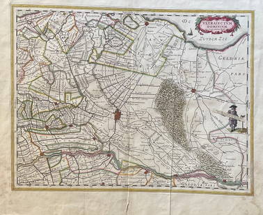
1 day LeftJasper521690 de Wit Map of Central Holland with Amsterdam -- Ultraiectini Dominii TabulaUS$190


![Bien: Antique Map of California as Island, 1889: Wheeler, George M[ontague]. . Washington: Julius Bien, Photo-lithograph, 1889. Quarto, one leaf. Fine. This is the map showing California as an island, and the northern part of present day Mexico and](https://p1.liveauctioneers.com/5584/107399/55057770_1_x.jpg?height=310&quality=70&version=1501794677)


![[MAP]. ORTELIUS, Abraham. Peregrinationis Divi Pauli Typus Corographicus. 1592. (1 of 2)](https://p1.liveauctioneers.com/197/329395/177650535_1_x.jpg?height=282&quality=70&version=1715364962)


