Sold2017Map of California & Nevada Borax Fields 1883Heading: (California & Nevada) Author: Title: Map of California and Nevada showing the locality of the principal borax fields to accompany the third annual report of the State Mineralogist of CaliforSee Sold Price
Sold20231894 ALASKA California 18 MAPS United States Geodetic Surveys State Boundaries1894 ALASKA California 18 MAPS United States Geodetic Surveys State Boundaries Throughout the 19th-century, the United States government published countless reports and surveys on natural history of ASee Sold Price
Sold20191850 California Convention Report State Constitution1850 California Convention Report State Constitution GOLD Rush Slavery MEXICO An interesting record of the formation of the state of California in its constitution and historical law. The "ConstitutioSee Sold Price
Sold20241854 California 1ed LAWS Congress Gold Rush American West 3v Sacramento RARE1854 California 1ed LAWS Congress Gold Rush American West 3v Sacramento RARE A collection of legislature reports from the State of California in the 1850s. Following the goldrush of the late 1840s, anSee Sold Price
Sold2021Hayden 12th Annual Report 1883 [Yellowstone]Twelfth Annual Report of the United States Geological and Geographical Survey of The Territories: A Report of Progress of the Exploration in Wyoming and Idaho (Yellowstone National Park) for the yearsSee Sold Price
Sold2021Report on California with maps 1850Heading: (California & New Mexico) Author: [Taylor, Zachary] Title: California and New Mexico: Message of the President of the United States, Transmitting information... on the Subject of California aSee Sold Price
Sold2024Annual Report of "Western States" by Wheeler, 1875 [178528]1875 Annual Report upon the Geographical Surveys of the Territory of the United States West of the 100th Meridian, in the States and Territories of California, Colorado, Kansas, Nebraska,Nebraska, NevSee Sold Price
Sold2020Maps and Seismograms San Francisco 1906 QuakeHeading: (California - San Francisco) Author: Lawson, Andrew C., et al. Title: Atlas of Maps and Seismograms Accompanying the Report of the State Earthquake Investigation Commission Upon the CaliforniSee Sold Price
Sold2017Mission And Plain Of San Fernando.Print: Mission And Plain Of San Fernando., 1860 Lithograph Size: 9.25 x 6.3 inches Sarony, Plate VI from Geology report, the United States Pacific Rail Road Exploration & Surveys - California. PleaseSee Sold Price
Sold2018California 1857 Lot of 12 Sheets of Etchings24 Etched Landscapes on 12 Sheets, disbound. San Bernardino etc. Published 1857, Washington for "Report on the United States and Mexican Boundary Survey" by Spencer Fullerton Baird. Paper Size: 11.5 xSee Sold Price
Sold20231857 Pacific Exploration RAILROAD Indians San Francisco California Fossils RARE1857 Pacific Exploration RAILROAD Indians San Francisco California Fossils RARE Beginning in 1855, the United States Congress published reports and surveys of certain railroad routes from the MississiSee Sold Price
Sold2023Report on Formation of the State of CaliforniaHeading: Author: Browne, J. Ross Title: Relacion de Los Debates de la Convencion de California, Sobre la Formacion de la Constitucion de Estado, en Setiembre Y Octubre de 1849 Place Published: NuevaSee Sold Price
Sold2021Report on Formation of the State of CaliforniaHeading: (Zamorano 80) Author: Browne, J. Ross Title: Relacion de Los Debates de la Convencion de California, Sobre la Formacion de la Constitucion de Estado, en Setiembre Y Octubre de 1849 Place PublSee Sold Price
Sold20221856 Messages of US President 35 Atlas MAPS Florida1856 Messages of US President 35 Atlas MAPS Florida New York California Pierce Throughout the 19th-century, printed examples of Congress reports and messages of the United States Presidents were regulSee Sold Price
Sold2020Monterey Under Three Flags 1894Heading: (California) Author: Title: Under Three Flags: A Collection of Views of Monterey, The Early Capital of California Under Spain, Mexico and the United States Place Published: San Francisco PubSee Sold Price
Sold2021Report before Congress on CA war on IndiansHeading: (California) Author: Title: California—Refund Money to State of, for Suppressing Indian Aggressions Place Published: [Washington, DC] Publisher:Committee on Military Affairs Date PublisSee Sold Price
Sold2022Map of the State California and NevadaMap of the State California and Nevada Dimensions: 10 x 13" Condition Report Good. Center fold as issued. Text on verso. Subject References: BL1830See Sold Price
Sold2023Williamson, Lieut. R. S. 1856 LG HC Map. California - First Geological Map"Geological Map of a Part of the State of California" Explored in 1855 by Lieut R. S. Williamson. Prepared to accompany the Report of William P. Blake. THE FIRST GEOLOGY MAP OF CALIFORNIA. Hand ColoreSee Sold Price
Sold2023Kingsburg, California Pocket Sharpening StoneKingsburg, California Antique Advertising Celluloid Pocket Hone. Measures 2.25 inches. Excellent condition. Provenance: Private collection Washington state. If lot is absent of a condition report oneSee Sold Price
Sold2018EIGHTH ANNUAL REPORT OF THE BOARD OF RAILROADEIGHTH ANNUAL REPORT OF THE BOARD OF RAILROAD COMMISSIONERS OF THE STATE OF CALIFORNIA FOR THE YEAR ENDING DECEMBER 31 1887 1888 Gilt Lettering Finance Tables Regulations Rules Investigations CompanieSee Sold Price
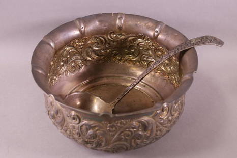
Sold20231894 STERLING PUNCH BOWL & LADLEENGRAVED TO UNITED STATES SENATOR STEPHEN WHITE. FIRST NATIVE CALIFORNIAN TO BE SENATOR OF CALIFORNIA. DENT TO RIM. 11 1/2" DIAM. APPROX 1058 GRAMS.See Sold Price
Sold2021California Stage Co. asks for govt. money, 1860Heading: (California Stage Company) Author: Hale, John P. Title: In the Senate of the United States. June 14, 1860... Mr. Hale made the following report. (To accompany Bill S. 507.) The Committee on PSee Sold Price
Sold2018U.S Coast Survey 1853 Map. Cortez Bank, California"Cortez Bank on the Western Coast of the United States" Electrotype Map Published 1843-65, Washington for "Report of the Superintendent of the U.S. Coast Survey..." Published under the supervision andSee Sold Price
Sold2023Williamson, Lieut. R. S. 1856 Map. California, New Mexico, Texas, Mexico"United States & Mexican Boundary Survery" Lithograph Map Published 1853-61, Washington for "Reports of explorations and surveys, to ascertain the most practicable and economical route for a railroadSee Sold Price
Jul 06Case Antiques, Inc. Auctions & AppraisalsEtching attrib. Paul Gauguin, La Femme aux FiguesUS$200


![Hayden 12th Annual Report 1883 [Yellowstone]: Twelfth Annual Report of the United States Geological and Geographical Survey of The Territories: A Report of Progress of the Exploration in Wyoming and Idaho (Yellowstone National Park) for the years](https://p1.liveauctioneers.com/5755/206309/104801833_1_x.jpg?height=310&quality=70&version=1622662726)
![Report on California with maps 1850: Heading: (California & New Mexico) Author: [Taylor, Zachary] Title: California and New Mexico: Message of the President of the United States, Transmitting information... on the Subject of California a](https://p1.liveauctioneers.com/642/197268/99581926_1_x.jpg?height=310&quality=70&version=1615593525)
![Annual Report of "Western States" by Wheeler, 1875 [178528]: 1875 Annual Report upon the Geographical Surveys of the Territory of the United States West of the 100th Meridian, in the States and Territories of California, Colorado, Kansas, Nebraska,Nebraska, Nev](https://p1.liveauctioneers.com/2699/324084/174414762_1_x.jpg?height=310&quality=70&version=1711485923)


![Report before Congress on CA war on Indians: Heading: (California) Author: Title: California—Refund Money to State of, for Suppressing Indian Aggressions Place Published: [Washington, DC] Publisher:Committee on Military Affairs Date Publis](https://p1.liveauctioneers.com/642/213263/108963644_1_x.jpg?height=310&quality=70&version=1627941972)