Sold20221893 Government Map of Civil War Era United States -- Map of the United States of America ShowingTitle: 1893 Government Map of Civil War Era United States -- Map of the United States of America Showing the Boundaries of the Union and Confederate Geographical Divisions and Departments CartographerSee Sold Price
Sold20221893 Government Map of Civil War Era United States -- Map of the United States of America ShowingTitle: 1893 Government Map of Civil War Era United States -- Map of the United States of America Showing the Boundaries of the Union and Confederate Geographical Divisions and Departments; Plate CLXIVSee Sold Price
Sold20221893 Government Map of Civil War Era United States -- Map of the United States of America ShowingTitle: 1893 Government Map of Civil War Era United States -- Map of the United States of America Showing the Boundaries of the Union and Confederate Geographical Divisions and Departments; Plate CLXIISee Sold Price
Sold2022AN AMERICAN CIVIL WAR ERA MAP, "United States of North America (Eastern & Central)," LONDON,AN AMERICAN CIVIL WAR ERA MAP, "United States of North America (Eastern & Central)," LONDON, 1861-1873, THEODORE ETTLING (b. 1823), hand colored lithograph on paper, by T. Ettling, published by CasselSee Sold Price
Sold2019United States. Civil war era military map. ShowingTitle/Content of Map: United States. Civil war era military map. Showing southern ports Date: 1863 Cartographer: By Johnson & Ward. From, Johnson’s New Illustrated Family Atlas Size: 18x 26 1/4”.See Sold Price
Sold2021CIVIL WAR-ERA JOHNSON'S MILITARY MAP UNITED STATESFramed engraving with color on paper, "Johnson's New Military Map of the United States, Showing the Forts, Military Posts & c., with Enlarged Plans of Southern Harbors from Authentic Data Obtained atSee Sold Price
Sold2015History Of The Civil War In The United StatesWood, W. Birkbeck. History of The Civil War In The United States... NY: Putnam's Sons. Includes Thirteen maps and Eleven (11) plans. Inv. 72See Sold Price
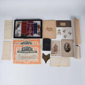
Sold2017CIVIL WAR ERA BUTTONS AND BADGESIncludes a Union Staff Officer Eagle Rank emblem, Confederate Major shoulder boards, Union Ordinance Dept buttons, Confederate buttons, Union Army Hat Badge, NY State button, and more.See Sold Price
Sold2017Civil War Era Map of the United StatesUnited States. Taliaferro Preston Shaffner (1811 – 1881). Lithographed Map. London: Schaffner, 1862. 12 1/4 x 18 1/2 inchesSee Sold Price
Sold2021Civil War era map of deep southern states, 1860/62Title: Civil War era map of deep southern states, 1860/62 Description: "Authentic vintage map of three deep south states whose partial borders are defined by the mighty Mississippi River, one of the gSee Sold Price
Sold2017Civil War Era Map of the United StatesMap of the United States and Territories. Henry F. Walling (1825 - 1889) & Ormando W. Gray (fl. 1860 – 1880). Lithographed Map. Boston, 1871. 17 x 25 1/2 inches sheetSee Sold Price
Sold2023US Civil War-Era Georgia State Button23mm coat size button. Convex two-piece construction. Reverse marked "*HORSTMANN*ALLIEN*N.Y.*. **Good condition overall. Some moderate wear to obverse with some fine details obscured. Shank is solid.*See Sold Price
Sold20182 Colton Civil War Maps, Military Stations & Forts, 3Two (2) Colton Civil War maps, 3 items total. 1st item: J.H. Colton, Civil War era map of the United States showing Military Stations and Forts, prepared for The Rebellion Record, New York: G.P. PutnaSee Sold Price
Sold20221864 Civil War MAP United States Statistics Commerce1864 Civil War MAP United States Statistics Commerce American Trade Gold Silver The United States Department of Treasury published this Civil War-era report analyzing the commerce of the US GovernmentSee Sold Price
Sold2022Civil War-era Fife by R. S. MeachamCivil War-era wooden fife, measuring 24″ long, manufactured by R. S. Meacham in Albany, New York. R.S. Meacham maintained a military and music store at 84 State Street in Albany, NY in the earlySee Sold Price
Sold2017Ettling: Map of United States of North America, 1860United States of North America (Eastern & Central) T. J. Ettling, c1860 17 x 25. This great Civil War era map covers the country from the Rocky Mountains to the Atlantic seaboard. The map is engravedSee Sold Price
Sold2022Pair of American Civil War Iron CannonballsNorth America, United States, Civil War era, ca. 1861 to 1865 CE. A fine pair of cast-iron cannonballs made to be fired out of the barrel of a cannon at opposing soldiers. Each spherical projectile feSee Sold Price
Sold2022Significant United States map, 1864 Johnson & WardVery interesting hand-colored map created at a pivotal time in the settlement of the American West. In this lovely Civil War era map many of the western states have still not settled their borders. ArSee Sold Price
Sold202319th C. American Civil War PowderhornOriginally listed at $400 North America, United States, Civil War era, ca. 1861 to 1865 CE. A curved powderhorn or powder flask shaped from a carved bull horn bearing smooth surfaces. Both the bottomSee Sold Price
202319th C. US Civil War Era Iron Grapeshots (3)**Originally Listed At $300** North America, United States, Civil War Era, ca. 1861 to 1865 CE. A collection of 3 large solid iron shot munitions for smoothbore guns, used during the American Civil WaSee Sold Price
Sold2023Civil War Era Itemsitems to include: Epaulette, Solider tin type, brass bleeder in case, pewter snuff box, powder horn with dog, early 1800's fork in leather case, Burr's map of New York State 1835 in poor condition, 18See Sold Price
Sold20181864 Johnson Map of the United States -- Johnson'sTitle/Content of Map: 1864 Johnson Map of the United States -- Johnson's United States Date: 1864, New York Cartographer: A Johnson Size: 16.9 x 23.1 in. This is a large, highly detailed Civil War eraSee Sold Price
Sold20211864 US Civil War Promotion & Pardon Letters, Deshazo**First Time At Auction** North America, United States, Alabama, Civil War era, ca. 1864 & 1865 CE. A pair of documents from the American Civil War both pertaining to the Confederate soldier, Rufus MoSee Sold Price
Sold2024Civil War era map of N. America with unsettled state bordersOne of the key maps in the 1860s Johnson series of North America. In this map Idaho Territory encompasses what would eventually become Idaho, Montana and Wyoming. Dakota Territory has yet to split intSee Sold Price
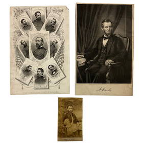
5 days LeftLakeshore Event CenterEphemera, Civil War Generals, Abraham Lincoln, Ulysses Grant, Lot of 3US$62(2 bids)
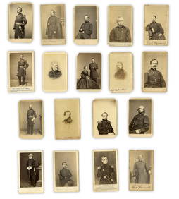
Jul 07Case Antiques, Inc. Auctions & Appraisals3 Civil War Era Photos, incl. Rose O'Neal Greenhow, poss. Jeff DavisUS$150
6 days LeftSchilb Antiquarian Rare Books1890 1ed Confederate Memoirs of Joseph Johnston & Jefferson Davis Civil War CSAUS$66(3 bids)
6 days LeftSchilb Antiquarian Rare Books1918 Robert E Lee Civil WAR Confederate General CSA Battles MAPS IllustratedUS$48(5 bids)
Jul 14Schilb Antiquarian Rare Books1928 Life of Abraham Lincoln 1ed SLAVERY Civil War Albert Beveridge 2v SETUS$1
Jul 04Weatherham Estate TreasuresAbraham Lincoln Bronze Bust Sculpture On Marble Base - Signed Original - 10lbsUS$400
Jun 26University ArchivesAbraham Lincoln PSA GEM MT 10 CDV, Signed 3 Weeks Before His Death.US$30,000
Jun 26University ArchivesCapture of Jefferson Davis: “Mr. Davis tried to escape…with a ladies waterproofUS$1,600
Jul 14Schilb Antiquarian Rare Books1885 Civil War 1ed Memoirs of Union General Ulysses S. Grant Illustrated MAPS 2vUS$120(5 bids)
6 days LeftSchilb Antiquarian Rare Books1860 Political Textbook 1ed SLAVERY Abe Lincoln Douglass Civil War GovernmentUS$74(4 bids)
Jul 06Case Antiques, Inc. Auctions & Appraisals7 Stephens and Davis CSA Items inc. ALS, Bust, CDVs and SealsUS$150(1 bid)
Jun 26University Archives18 pc. CDV Archive of Civil War Generals Incl. Many Brady & E. Anthony ExamplesUS$260(1 bid)
Jul 06Case Antiques, Inc. Auctions & AppraisalsCivil War Veteran GAR Uniform, PVT Stephen F. OliverUS$200(1 bid)
Jun 26University ArchivesIconic U.S. Grant Battlefield Albumen by Mathew Brady at City Point During Siege of PetersburgUS$400