Sold2016Early Map of The Michigan Territory by CareyThe Upper Territories of the United States, 1814. Matthew Carey (1760-1839). Engraved map with original hand color in outline. Philadelphia, 1814. 22 x 17 1/4 inches sheet. The map reflects a very earSee Sold Price
Sold20241839 Map of North America with the Republic of Texas. By MoninTitle: 1839 Map of North America with the Republic of Texas. By Monin Date/Period: 1839 Materials: Hand colored, engraved Size: 17 1/2 x 12 1/2" This map is a stunning representation of North AmericaSee Sold Price
Sold2016Geographical Statistical Historical Michigan Map, 1822Map: Geographical, Statistical and Historical Map of Michigan Territory Cartographer: Carey & Lea Publishing: Philadelphia, 1822 Size: 17 x 21.8 inches This is the first map only focused on Michigan TSee Sold Price
Sold20221868 1ed Dakota Land History INDIANS Minnesota Wisconsin Michigan MAP Hankins1868 1ed Dakota Land History INDIANS Minnesota Wisconsin Michigan MAP Hankins Colonel Hankins Dakota Land is a fascinating post-Civil War survey of the geography and history of Minnesota, Wisconsin, aSee Sold Price
Sold2017Heirs: Contemporary Map of the 18th Century World, 1744Map: Asia, Secundum Legitimas Projectionis Stereogtraphicae Regulas Et Juxta Recentissimas Observationes Et Relationes Maker: Homann Heirs Size: Folio - 18.30 H x 21.20 W Inches Published: Nuremburg,See Sold Price
Sold20211839 MAP OF ULSTER COUNTY, NEW YORK, BY DAVID H. BURR,1839 MAP OF ULSTER COUNTY, NEW YORK, BY DAVID H. BURR, STONE & CLARK PUBLISHERS, ITHICA, N.Y. NICELY FRAMED, FROM PROMINENT ELLENVILLE, N.Y. ATTORNEYS OFFICE. MAP MEASURES 22" X 23", NICELY FRAMED, ANSee Sold Price
Sold2022Contemporary Michigan Wolverines Pedal CarContemporary Michigan Wolverines pedal car. Good condition with some scuffs and wear from storage and display. Measures approximately 33" long.See Sold Price
Sold2022Contemporary Map Pig Whiskey FlaskSgraffito with brown glaze stoneware, male pig, marked Time of Trains 1915 by WA Pottery Works Kansas City U.S.A. 2000, with map on left side, opening at rear, 7 1/2" long x 2 3/4" wide x 3 1/4" high.See Sold Price
Sold2017Jeremiah Greenleaf: Michigan MapMap: Michigan Description: This is a map of the young Michigan with Greenleaf's keyboard-style border, detailing the topography, color-coded counties, roads, towns and villages, and more. The countiesSee Sold Price
Sold2021A Contemporary Map of North America. Matted and framed.A Contemporary Map of North America. Matted and framed. Color lithograph 41 1/4 x 41 1/4 inches (sight). Property from a Corporate Art CollectionSee Sold Price
Sold20201839 Maps, Middle States, Burgess, MitchellTwo hand colored maps, both dated 1839: "Map of the Middle States and part of the Southern, Engraved to Illustrate Mitchells School and family Geography" by S. Augustus Mitchell, engraved by J. H. YouSee Sold Price
Sold20241839. Map of Australia and Pacific by MoninTitle: 1839. Map of Australia and Pacific by Monin Date/Period: 1839 Materials: Hand colored, engraved Size: 17 1/2 x 12 1/2" This is a map of Australia and the Pacific in 1839 when the continent wasSee Sold Price
Sold20211839 Map of the Southern States, SmithHandsome map drawn and engraved by Stiles, Sherman & Smith to accompany Smith’s Geography for Schools. Shows the entire deep south except for the lower half of Florida. Shows the navigable distanceSee Sold Price
Sold20241839 Map of Norway and Sweden with insert of Iceland by MoninTitle: 1839 Map of Norway and Sweden with insert of Iceland by Monin Date/Period: 1839 Materials: Hand colored, engraved Size: 17 1/2” x 12 1/2” 1839. By V. Monin. Paris. Hand-colored, engSee Sold Price
Sold2019CONTEMPORARY MAP OF NORTH AMERICADimensions: (Frame) H 21" x W 18" Condition: Creasing.See Sold Price
Sold20231839 Map of United Kingdom and Ireland by MoninTitle: 1839 Map of United Kingdom and Ireland by Monin Date/Period: 1839 Materials: Hand colored, engraved Size: 17 1/2” x 12 1/2” 1839. By V. Monin. Paris. Hand-colored, engraved. Good coSee Sold Price
Sold20211883 Michigan MapAuthor: Cram Title: 1883 Michigan Map Medium: Ink on Paper Dimensions: 10.5"X13.5" Map of Michigan dated 1883. Printed and published by George Cram in Chicago. Part of his Family Atlas. Key upper righSee Sold Price
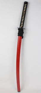
Sold2018CONTEMPORARY REPLICA JAPANESE KATANA SWORDCONTEMPORARY REPLICA JAPANESE KATANA SWORD Contemporary replica of a Japanese katana sword. The sword blade is intentionally dulled. Size: 39" in total, 27" blade Shipping / Pickup: We Can Ship This ISee Sold Price
Sold20241839 Map of Netherlands and Belgium by MoninTitle: 1839 Map of Netherlands and Belgium by Monin Date/Period: 1839 Materials: Hand colored, engraved Size: 17 1/2” x 12 1/2” Netherlands and Belgium with Luxembourg. 1839. By V. Monin.See Sold Price
Sold2021(MICHIGAN.) Maps and Report . . . for Ascertaining the(MICHIGAN.) Maps and Report . . . for Ascertaining the Northern and Northwestern Boundary between the United States and Great Britain. 8 maps with hand-colored border in blue and red. 2 text leaves. FSee Sold Price
Sold201910 Flint Points, Contemporary Replicas of Mid West10 Flint Points, Contemporary Replicas of Mid West "Dove Tail" StyleSee Sold Price
Sold20192 Contemporary Replicas of Banner Stones2 Contemporary Replicas of Banner StonesSee Sold Price
Sold2019Group of Stone Items - Contemporary Replicas of MostlyGroup of Stone Items - Contemporary Replicas of Mostly Midwest StylesSee Sold Price
Jun 14DuMouchellesWilliam H. Gamble (American, B. 1863) Hand Colored Engraving, Ca. 1863, "County Map of Michigan AndUS$50(1 bid)
1 day LeftFreeman's | HindmanDICKENS, Charles (1812-1870). A group of 6 novels, many FIRST EDITIONS, comprising:US$250
2 days LeftFreeman's | HindmanMURCHISON, Roderick Impey, Sir. The Silurian System. 1839. COMPLETE WITH VERY RARE HAND-COLOREDUS$1,500
2 days LeftFreeman's | HindmanHARDY, Thomas. The Works of Thomas Hardy in Prose and Verse With Prefaces and Notes. 1912-1913.US$300
16 hrs LeftJasper52WEST AFRICA showing early explorers' routes & Mountains of Kong. SDUK 1844 mapUS$40
16 hrs LeftJasper52NIGERIA early explorers' routes. Lake Chad. Yariba Houssa Borgou SDUK 1844 mapUS$45
16 hrs LeftJasper52NIGERIA w/ early explorers' routes. Lake Chad Yariba Houssa Borgou.SDUK 1844 mapUS$60
Jun 22Contemporary CollectiblesF. Murray Abraham Autographed Signed Oscar Replica Hollywood Award JSA CertifiedUS$50
Jun 22Contemporary CollectiblesBoba Fett replica blaster autographed by Jeremy Bulloch. This item is 24 inches long. Item is JSAUS$150
Jun 22Contemporary CollectiblesRetro Microphone Autographed by Tracey Morgan. Mic does not work as it is a replica. Item is JSAUS$200